Cliffside Trail: Difference between revisions
(Adding unused image) |
(update map and IB) |
||
| Line 1: | Line 1: | ||
<!-- The following few lines create the "Infobox" table template. Please scroll down to edit the main content of the article. --> | <!-- The following few lines create the "Infobox" table template. Please scroll down to edit the main content of the article. --> | ||
{{Infobox Trail | {{Infobox Trail | ||
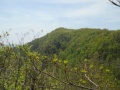
| Image Name = BMP Cliffside Trail view from obs tower towards firetower.JPG | |||
| Park = Bays Mountain Park | |||
| City = Kingsport | |||
| State = Tennessee | |||
| Marking = Signs | |||
| Trail Use = {{Hike}} {{Dogs}} | |||
| Difficulty Rating = Medium | |||
| Hike Time = 30 Min | |||
| Round Trip Distance = 1.0 Mi | |||
| Trail Distance = 0.78 Mi | |||
| Trail Type = Loop | |||
| Elevation Gain = 373 Ft | |||
| Elevation Loss = -373 Ft | |||
| High Point = 2,197 Ft | |||
| Parking coords = 36.508821,-82.609545 | |||
| Trailhead coords = 36.508124,-82.610851 | |||
| Medical = Kingsport, TN | |||
}} | }} | ||
<!-- End Infobox template table--> | <!-- End Infobox template table--> | ||
<!-- Start of Main Page --> | <!-- Start of Main Page --> | ||
== Trail Overview == | == Trail Overview == | ||
<!-- Enter a overview of the trail. What attracts you to this trail, points of interest, types of flowers, lakes, and peaks that you see along the way. --> | <!-- Enter a overview of the trail. What attracts you to this trail, points of interest, types of flowers, lakes, and peaks that you see along the way. --> | ||
| Line 71: | Line 73: | ||
== Maps == | == Maps == | ||
<!-- You can place pictures, PDF's, links, or even create a Google map with your waypoints and place it here. --> | <!-- You can place pictures, PDF's, links, or even create a Google map with your waypoints and place it here. --> | ||
< | <display_map center="36.50818,-82.61083" type="terrain" zoom="15" width="auto" height="550" gkml="http://tehcc.org/clubwiki/kml/BMP_Cliffside_Trail.kml, | ||
http://tehcc.org/clubwiki/kml/BMP_Cliffside_Trail.kml | http://tehcc.org/clubwiki/kml/BMP_bays_mountain_road.kml"> | ||
http://tehcc.org/clubwiki/kml/BMP_bays_mountain_road.kml | |||
36.50816,-82.61087~Trailhead near observatory at "Sun"~[[Image:BMP Cliffside Trail sun.jpg|150px]]~MarkerT.png | |||
Trailhead near observatory at "Sun" | 36.50856,-82.60453~Trailhead at Bays Mountain Road~ ~MarkerT.png | ||
[[Image:BMP Cliffside Trail sun.jpg|150px]] | 36.50657,-82.60898~Trail splits for old steps and alternative route~ ~MarkerG.png | ||
36.50845,-82.60445~Observation tower~[[Image:BMP_Cliffside_Trail_lookout.JPG|150px]]~MarkerE.png | |||
Trailhead at Bays Mountain Road | 36.50788,-82.61073~View from lower overlook by observatory~[[Image:BMP Cliffside Trail lower overlook.JPG|150px]]~MarkerE.png | ||
36.50673,-82.60985~View from higher overlook along trail~[[Image:BMP Cliffside Trail higher overlook.JPG|150px]]~MarkerE.png | |||
Trail splits for old steps and alternative route | </display_map> | ||
Observation tower | |||
[[Image:BMP_Cliffside_Trail_lookout.JPG|150px]] | |||
View from lower overlook by observatory | |||
[[Image:BMP Cliffside Trail lower overlook.JPG|150px]] | |||
View from higher overlook along trail | |||
[[Image:BMP Cliffside Trail higher overlook.JPG|150px]] | |||
</ | |||
Revision as of 19:59, 30 September 2015
| |||||||||||||||||||||||||||||||||||||||||||||

Trail Overview
Located in Bays Mountain Park. Up and along the ridgeline to a lookout tower.
How to get there
From the main parking lot, head over to the observatory. The unmarked trail heads uphill from here. Alternatively, head up Bays Mountain Road to observation tower and take the trail back down.
Route Description
Short steep hike along the ridgeline with couple of lookout points and up to the observation tower.
| Miles | Cliffside Trail | Miles |
|---|---|---|
| 0.0 | Trailhead at Astronomical Observatory (by "Sun" on solar model"). Also first overlook nearby. | 0.5 |
| 0.1 | Overlook near gate on Bays Mountain Road | 0.4 |
| 0.2 | Trail split. Up stairs is older route. Ahead is newer sidetrail alternative shown on park map. | 0.3 |
| 0.4 | Trail split on ridgeline. Down is newer sidetrail alternative shown on park map, while follow ridge to older route. | 0.1 |
| 0.5 | Observation Tower/Junction with Bays Mountain Road | 0.0 |
Typical Conditions
The older trail route is very worn and washed out on steep ascent with stone steps built long ago. Pine needle covered path once up on ridgeline. Alternate route is newer sidehill trail in excellent condition.
Regulations
NO BIKES!
Misc. Information
Selective removal of some trees around the lookout tower would greatly improve viewing year around.
Maps
- The following elevation profile travels from by the observatory up the main trail on the stairs and back down the alternate path.

Photos
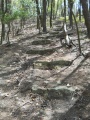
Older steps up Cliffside Trail
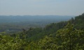
View from higher overlook along trail
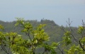
View from observation tower towards firetower
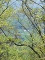
View from obs tower towards valley
View from the lower overlook along trail


