Chestnut Trail: Difference between revisions
(→Photos: Added a photo) |
m (→Photos: fixed typo) |
||
| Line 63: | Line 63: | ||
<!-- Place any pictures from this trail below. Ideally we would have a picture of the trailhead to help people know when they found it --> | <!-- Place any pictures from this trail below. Ideally we would have a picture of the trailhead to help people know when they found it --> | ||
<!-- Add a picture by typing Image:imagename.extension --> | <!-- Add a picture by typing Image:imagename.extension --> | ||
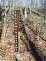
Image:BMP_Chestnut_Trail2.JPG|Intersection with | Image:BMP_Chestnut_Trail2.JPG|Intersection with Azalea and Big Oak | ||
<!-- Do not remove the end gallery code.--> | <!-- Do not remove the end gallery code.--> | ||
Revision as of 22:08, 27 December 2013
| |||||||||||||||||||||||||||||||||||||
Trail Overview
Located in Bays Mountain Park. Beginner single track mountain biking trail constructed by the Northeast Tennessee Mountain Bike Association. Good for an easy ride or hike through hardwood forest.
How to get there
From the main parking lot, head up Bays Mountain Road to the locked service gate near the maintenance parking area. To the west is the marked trail heading into the forest. Or take Lake Road around to Azalea Trail and head uphill to the other end.
Route Description
Straight level (< 1% grade) 1.6 mile single track biking path through the forest. (Trailhead sign says 1.7 mi., but measured 1.6 mi. twice.)
For a 70 minute loop hike, take Chestnut Trail from the gate to Big Oak Trail, and back on Lake Road.
For a 5 mile loop hike/ride, start with the same route, but from Big Oak Trail take the Chinquapin Trail around to Lake Road.
Typical Conditions
Hard packed trail with groove down the middle from the mountain bikes. No designed passing zones, so be careful of riders coming both ways!
Misc. Information
Maps
Green line is the Chestnut Trail. Yellow is Azalea Trail. Red line on the left (NW) is the Big Oak Trail. Red trace on the right (SE) is Bays Mountain Road.
<googlemap version="0.9" lat="36.516" lon="-82.612" type="terrain" zoom="14" width="625" icons="http://tehcc.org/clubwiki/kml/marker{label}.png"> http://tehcc.org/clubwiki/kml/BMP_Chestnut_Trail.kml http://tehcc.org/clubwiki/kml/BMP_lake_road.kml http://tehcc.org/clubwiki/kml/BMP_bays_mountain_road.kml http://tehcc.org/clubwiki/kml/BMP_Azalea_Trail.kml http://tehcc.org/clubwiki/kml/BMP_Big_Oak_Trail.kml
(G) 36.50724,-82.60955
Trailhead at Bays Mountain Road
 (G) 36.52238,-82.59285
Trailhead at Azalea/Big Oak trails
</googlemap>
(G) 36.52238,-82.59285
Trailhead at Azalea/Big Oak trails
</googlemap>
Photos
Intersection with Azalea and Big Oak
