Chinquapin Trail
| Chinquapin Trail (log in to submit report) | |
|---|---|

| |
| Park | Bays Mountain Park |
| Land Owner | City of Kingsport |
| Located | Kingsport, TennesseeLocation inherited from associated park |
| Trail Marking | Signs |
| Trail UseThings allowed to do on or near the trail |
|
| FeaturesThings to see on or near the trail |
|
| Difficulty Rating | Medium |
| Hiking TimeTime from car and back. Includes any time hiking to access this trail. | 60 min1 Hours <br />0.0625 Days <br /> round trip |
| Distance: | 1.556 mi2.504 km <br /> trailStrict non-repeating trail length / 3.5 mi5.633 km <br /> round tripTypical or shortest length from the car, hike the trail, and return to car |
| Trail Type | Segment |
| Low / High Point | 1,854 ft618 Yards <br />565.099 Meters <br /> / 1,998 Ft666 Yards <br />608.99 Meters <br /> |
| Elev. Gain/LossSee link for details of calculation. Gain/Loss is direction dependent. | 145 Ft44.196 Meters <br /> / (182 Ft55.474 Meters <br />) – East-to-West |
| Trip ReportsFrom user "hiked it" submissions<br />Recent is within last 90 days | No hikes logged yet |
| NearbyWithin 5 mi<br />Click link to view list | 30 trails / 36.9 mi of trail |
| Parking | 36° 30' 31.75" N, 82° 36' 34.38" W Map |
| Trailhead | 36° 30' 52.20" N, 82° 36' 21.85" W Map |
|
| |
| Show In Google Maps | |
Download KML / Upload new version / KML File Page / Create Profile Chart / gpsvisualizer Map
Trail Overview
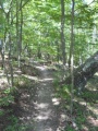
Located in Bays Mountain Park. New mountain biking trail constructed by the local club. Good for an easier ride or hike through hardwood forest dotted with hemlocks.
How to get there
From the main parking lot, take Lake Road around to unmarked trailhead or jump on Big Oak for short distance for other trailhead.
Route Description

The path meanders through the forest with planned switchbacks and bridge crossing.
This trail has connections to Big Oak Trail, Fire Tower Trail, Lake Road, and Lakeside Trail.
| Miles | Chinquapin Trail | Miles |
|---|---|---|
| 0.0 | Trailhead at Lake Road | 1.85 |
| 0.7 | Junction with Fire Tower Trail | 1.15 |
| 1.85 | Trailhead at Big Oak Trail | 0.0 |
Typical Conditions
Hard packed trail with groove down the middle from the mountain bikes. Some rocks located at key spots. Several wood bridges constructed by BSA Troop 51.
Photos
-
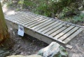
Boy Scouts of America Built Bridge
-
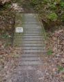
Boy Scouts of America Built Bridge
-
-

Trail Profile

