Chestnut Ridge: Difference between revisions
(→Maps: add waypoints) |
m (move profile down to route) |
||
| (9 intermediate revisions by the same user not shown) | |||
| Line 1: | Line 1: | ||
{{Trail | |||
{{ | |Banner Image=File:Roan view from Miller cemetery platform.jpg | ||
|Park=Roan Mountain State Park | |||
|Trail Marking=Orange | |||
|Trail Use=Hiking | |||
|Trail Features=Vistas, Mountains | |||
|Difficulty Rating=Medium | |||
|Hike Time=1.5 hrs | |||
|Trail Distance=2.193 mi | |||
|Round Trip Distance=4.4 mi | |||
|Trail Type=In-and-Out | |||
|High Point=3,773 ft | |||
|Low Point=2,841 ft | |||
|Elevation Gain=319 ft | |||
|Elevation Loss=1,162 ft | |||
|Elevation Change Direction=West-to-East | |||
|Parking location=36.17878, -82.11264 | |||
|Trailhead location=36.17827, -82.11234 | |||
}} | }} | ||
{{Trail Map|Other Trails=Forest Road}} | |||
__TOC__ | |||
== Trail Overview == | == Trail Overview == | ||
Chestnut Ridge Trail is the highest and steepest and therefore most challenging trail of the [[Roan Mountain State Park]] trail system. Offering the most remote and secluded hike within the park. Leave the Miller homestead imagining it's 100 years ago and you're a family member headed to town for some supplies. If you want to get away and not hear cars roaring by for a while, hike this trail. It's recommended to get shuttled or car pool to Miller Homestead parking lot to avoid the very long and steep ascent to return. Hike down to Forest Road Trail and continue to either the Visitor center to the left or head right and make your way back to the cabins or campground. | Chestnut Ridge Trail is the highest and steepest and therefore most challenging trail of the [[Roan Mountain State Park]] trail system. Offering the most remote and secluded hike within the park. Leave the Miller homestead imagining it's 100 years ago and you're a family member headed to town for some supplies. If you want to get away and not hear cars roaring by for a while, hike this trail. It's recommended to get shuttled or car pool to Miller Homestead parking lot to avoid the very long and steep ascent to return. Hike down to Forest Road Trail and continue to either the Visitor center to the left or head right and make your way back to the cabins or campground. | ||
| Line 33: | Line 34: | ||
== Route Description== | == Route Description== | ||
[[File:Chestnut ridge trail profile.png|thumb|right]] | |||
The trail begins at Miller Homestead and heads east along Chestnut Ridge until it meets up with [[Trail connects to::Forest Road|Forest Road Trail]]. | The trail begins at Miller Homestead and heads east along Chestnut Ridge until it meets up with [[Trail connects to::Forest Road|Forest Road Trail]]. | ||
{| class="wikitable" border="1" | |||
|- | |||
!Miles Out | |||
!{{PAGENAME}} | |||
!Miles Back | |||
!Elevation (ft) | |||
|- | |||
|0.0 | |||
|Trail head | |||
|2.26 | |||
|3,680 | |||
|- | |||
|0.25 | |||
|Cemetery and lookout | |||
|2.01 | |||
|3,750 | |||
|- | |||
|0.8 | |||
|2015 large blowdown, difficult passing | |||
|1.46 | |||
|3,547 | |||
|- | |||
|1.06 | |||
|Walk along road trail on neighboring property | |||
|1.20 | |||
|3,593 | |||
|- | |||
|1.34 | |||
|Steep descent - no stairs | |||
|0.92 | |||
|3,544 | |||
|- | |||
|2.26 | |||
|Connection to Forest Road Trail | |||
|0.0 | |||
|2,912 | |||
|} | |||
== Typical Conditions == | == Typical Conditions == | ||
| Line 42: | Line 81: | ||
The typical foliage up top is mostly deciduous trees with a few pines. The middle layer is classic Roan Mountain rhododendron, and the ground cover seems to be predominated with ferns. | The typical foliage up top is mostly deciduous trees with a few pines. The middle layer is classic Roan Mountain rhododendron, and the ground cover seems to be predominated with ferns. | ||
The trail is decently maintained and likely doesn't see much traffic. It's a fairly narrow trail in parts and the steep descent is lacking steps in most places. A hike up the ridge is likely | The trail is decently maintained and likely doesn't see much traffic. It's a fairly narrow trail in parts and the steep descent is lacking steps in most places. A hike up the ridge is likely challenging. | ||
== Misc. Information == | == Misc. Information == | ||
<!-- Enter any additional information that doesn't fit an any other fields. Any seasonal features, factoids, etc...? --> | <!-- Enter any additional information that doesn't fit an any other fields. Any seasonal features, factoids, etc...? --> | ||
Historical access to Miller Homestead was not by this trail or the current day road. Routine access to town or church was through the back of the property, behind the barn. | |||
== Photos == | == Photos == | ||
{{Park trail gallery|Trail={{PAGENAME}}}} | |||
{{Map Marker|Icon Type=Parking|Marker Title=Parking|Marker Description= |Marker Location=36.178777,-82.112637}} | |||
{{Map Marker|Icon Type=Point of interest|Marker Title=Trail head|Marker Description=[[Image:Roan Chestnut Miller Trail head.jpg|150px|Trail head at Miller Homestead]]|Marker Location=36.178268,-82.112341}} | |||
{{Map Marker|Icon Type=Cemetery|Marker Title=Cemetery|Marker Description= |Marker Location=36.180565,-82.110898}} | |||
{{Map Marker|Icon Type=Overlook|Marker Title=Viewing platform|Marker Description=[[Image:Roan view from Miller cemetery platform.jpg|150px|View from platform]]|Marker Location=36.180151,-82.110902}} | |||
Image:Roan Chestnut Miller Trail head.jpg|Trail head at Miller Homestead | {{Map Marker|Icon Type=Trail sign|Marker Title=Junction with [[Forest Road|Forest Road Trail]]|Marker Description=[[Image:Roan intersection of Chestnut and Forest Road.jpg|150px|Intersection of Chestnut and Forest Road]]|Marker Location=36.173185,-82.090658}} | ||
Image:Roan view from Miller cemetery platform.jpg|View from | |||
[[ | |||
Latest revision as of 17:34, 20 December 2019
| Chestnut Ridge (log in to submit report) | |
|---|---|

| |
| Park | Roan Mountain State Park |
| Located | Roan Mountain, TennesseeLocation inherited from associated park |
| Trail Marking | Orange |
| Trail UseThings allowed to do on or near the trail |
|
| FeaturesThings to see on or near the trail |
|
| Difficulty Rating | Medium |
| Hiking TimeTime from car and back. Includes any time hiking to access this trail. | 1.5 hrs0.0938 Days <br />90 Min <br /> round trip |
| Distance: | 2.193 mi3.529 km <br /> trailStrict non-repeating trail length / 4.4 mi7.081 km <br /> round tripTypical or shortest length from the car, hike the trail, and return to car |
| Trail Type | In-and-Out |
| Low / High Point | 2,841 ft947 Yards <br />865.937 Meters <br /> / 3,773 ft1,257.667 Yards <br />1,150.01 Meters <br /> |
| Elev. Gain/LossSee link for details of calculation. Gain/Loss is direction dependent. | 319 ft97.231 Meters <br /> / (1,162 ft354.178 Meters <br />) – West-to-East |
| Trip ReportsFrom user "hiked it" submissions<br />Recent is within last 90 days | No hikes logged yet |
| NearbyWithin 5 mi<br />Click link to view list | 11 trails / 25.3 mi of trail |
| Parking | 36° 10' 43.61" N, 82° 6' 45.50" W Map |
| Trailhead | 36° 10' 41.77" N, 82° 6' 44.42" W Map |
|
| |
| Show In Google Maps | |
Download KML / Upload new version / KML File Page / Create Profile Chart / gpsvisualizer Map
Trail Overview[edit]
Chestnut Ridge Trail is the highest and steepest and therefore most challenging trail of the Roan Mountain State Park trail system. Offering the most remote and secluded hike within the park. Leave the Miller homestead imagining it's 100 years ago and you're a family member headed to town for some supplies. If you want to get away and not hear cars roaring by for a while, hike this trail. It's recommended to get shuttled or car pool to Miller Homestead parking lot to avoid the very long and steep ascent to return. Hike down to Forest Road Trail and continue to either the Visitor center to the left or head right and make your way back to the cabins or campground.
How to get there[edit]
From the park Visitor Center to begin at the Miller Homestead
- Drive south on 143
- Make the right turn to the signed Miller Homestead
- Follow the road up to the parking lot overlooking the homestead, or choose to drive a little farther to the cemetery and park
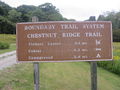
- Facing the overlook to the right of the cemetery, the trail begins to the left between the overlook and cemetery
Route Description[edit]

The trail begins at Miller Homestead and heads east along Chestnut Ridge until it meets up with Forest Road Trail.
| Miles Out | Chestnut Ridge | Miles Back | Elevation (ft) |
|---|---|---|---|
| 0.0 | Trail head | 2.26 | 3,680 |
| 0.25 | Cemetery and lookout | 2.01 | 3,750 |
| 0.8 | 2015 large blowdown, difficult passing | 1.46 | 3,547 |
| 1.06 | Walk along road trail on neighboring property | 1.20 | 3,593 |
| 1.34 | Steep descent - no stairs | 0.92 | 3,544 |
| 2.26 | Connection to Forest Road Trail | 0.0 | 2,912 |
Typical Conditions[edit]
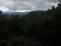
A classic Appalachian hiking trail. You're up on a ridge, but the trees obscure 90% of the view to the surrounding mountains. A winter hike after the leaves have fallen would likely offer wonderful views.
The typical foliage up top is mostly deciduous trees with a few pines. The middle layer is classic Roan Mountain rhododendron, and the ground cover seems to be predominated with ferns.
The trail is decently maintained and likely doesn't see much traffic. It's a fairly narrow trail in parts and the steep descent is lacking steps in most places. A hike up the ridge is likely challenging.
Misc. Information[edit]
Historical access to Miller Homestead was not by this trail or the current day road. Routine access to town or church was through the back of the property, behind the barn.
Photos[edit]

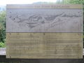
Roan Highlands Horizon Map
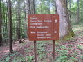
Trail head at Miller Homestead
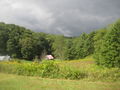
Miller Homestead
Intersection of Chestnut and Forest Road
View from cemetery platform


