|
|
|
|
|
| Trail Name
|
Boneyard Connector
|
| Park
|
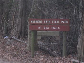
Warriors Path State Park
|
| Nearest City
|
Kingsport
|
| State
|
Tennessee
|
| Trail Marking
|
None
|
| Trail Use/Features
|
  
|
| Difficulty Rating
|
Hard
|
| Hiking Time
|
5 Min0.0833 Hours <br />0.00521 Days <br />
|
Distance:
round-trip/trail only
|
0.2 Mi0.322 km <br /> / 235 Ft0.0445 Mi <br />0.0716 km <br />
|
| Trail Type
|
Segment
|
| Climb/Descent Elevation
|
32.3 Ft9.845 Meters <br /> / -22.7 Ft-6.919 Meters <br />
|
| High Point
|
1,474 Ft491.333 Yards <br />449.275 Meters <br />
|
| Parking
|
36° 29' 31.67" N, 82° 28' 6.85" W
|
| Trailhead
|
36° 29' 28.51" N, 82° 28' 11.77" W
|
| Nearest Medical
|
Indian Path Hospital
|
| Trip Reports
|
Click Here
|
|
|
Loading map... {"type":"ROADMAP","minzoom":false,"maxzoom":false,"types":["ROADMAP","SATELLITE","HYBRID","TERRAIN"],"mappingservice":"googlemaps3","width":"270px","height":"180px","centre":false,"title":"","label":"","icon":"","lines":[],"polygons":[],"circles":[],"rectangles":[],"copycoords":false,"static":false,"visitedicon":"","wmsoverlay":false,"zoom":8,"layers":[],"controls":["zoom"],"zoomstyle":"DEFAULT","typestyle":"DEFAULT","autoinfowindows":false,"resizable":false,"kmlrezoom":false,"poi":true,"cluster":false,"clustergridsize":60,"clustermaxzoom":20,"clusterzoomonclick":true,"clusteraveragecenter":true,"clusterminsize":2,"imageoverlays":[],"kml":[],"gkml":[],"searchmarkers":"","fullscreen":false,"scrollwheelzoom":false,"locations":[{"text":"","title":"","link":"","lat":36.492130000000003064997144974768161773681640625,"lon":-82.4685699999999997089616954326629638671875,"icon":""}]} |
|
| Show Large Map
|
|
Trail Overview
Located in Warriors Path State Park as part of their Mountain Bike Trail system. This very short connector is used to access other trails farther out.
How to get there
From main entrance of Warriors Path State Park:
- Go north on Fall Creek Road for 2.4 miles.
- Turn right (east) onto Old Mill Road for 0.8 miles.
- Turn right (south) onto Childress Ferry Road for just roughly 100 yards.
- Turn left (east) onto Buttermilk Road for 1.2 miles.
- Turn right (south) onto Freeman Road for 0.5 mile.
- Continue when road changes from asphalt to gravel.
Trailhead at gravel parking lot.
Route Description
This trail has connections to Lake Road, Fawn Loop, Boneyard, and Darwin's Revenge.
Typical Conditions
The mountain biking association SORBA Tri-Cities handles the trail maintenance, thus generally in good condition. While there are no blazes to guide you through the forest, the narrow single tracks are well established. Grab a trail map at the parking lot kiosk to help you decipher intersections; some which could use signs. Be aware for approaching bike riders who can come up quickly on your group. Step aside to let them safely pass.
Fees, Permits, etc.
No fee required. Dogs are allowed on or off leash. Do not drink any water without treatment!
After the Hike
Misc. Information
Maps
Click the official trail map:
File:Warriors-MTB-Trails.pdf
State Park Map
Fawn loop is shown as orange. Darwin's Revenge is the red line. Boneyard is dark green.
Loading map...
{"type":"TERRAIN","minzoom":false,"maxzoom":false,"types":["ROADMAP","SATELLITE","HYBRID","TERRAIN"],"mappingservice":"googlemaps3","width":"auto","height":"550px","centre":{"text":"","title":"","link":"","lat":36.49150999999999811507223057560622692108154296875,"lon":-82.46922000000000707586877979338169097900390625,"icon":""},"title":"","label":"","icon":"","lines":[],"polygons":[],"circles":[],"rectangles":[],"copycoords":false,"static":false,"visitedicon":"","wmsoverlay":false,"zoom":18,"layers":[],"controls":["pan","zoom","type","scale","streetview","rotate"],"zoomstyle":"DEFAULT","typestyle":"DEFAULT","autoinfowindows":false,"resizable":false,"kmlrezoom":false,"poi":true,"cluster":false,"clustergridsize":60,"clustermaxzoom":20,"clusterzoomonclick":true,"clusteraveragecenter":true,"clusterminsize":2,"imageoverlays":[],"kml":[],"gkml":["http://tehcc.org/clubwiki/kml/WPSP_Boneyard_Connector.kml","http://tehcc.org/clubwiki/kml/WPSP_Boneyard.kml","http://tehcc.org/clubwiki/kml/WPSP_Darwins_Revenge.kml"],"searchmarkers":"","fullscreen":false,"scrollwheelzoom":false,"locations":[]}
Photos
