|
|
| Line 1: |
Line 1: |
| <!-- The following few lines create the "Infobox" table template. Please scroll down to edit the main content of the article. --> | | <!-- The following few lines create the "Infobox" table template. Please scroll down to edit the main content of the article. |
| {{Infobox Trail | | -->{{Infobox Trail |
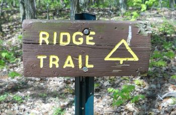
| | Image Name = BMP Bays Ridge Trail sign.JPG | | | Image Name = BMP Bays Ridge Trail sign.JPG |
| | Trail Number = | | | Trail Number = |
| Line 19: |
Line 19: |
| | Trailhead coords = 36.497512,-82.622293 | | | Trailhead coords = 36.497512,-82.622293 |
| | Medical = Kingsport, TN | | | Medical = Kingsport, TN |
| }} | | }}<!-- |
| <!-- End Infobox template table--> | | |
| <!-- Start of Main Page --> | | End Infobox template table |
| | |
| | -->{{Trail page needs |
| | | Hide needs = |
| | | KML = |
| | | Updated KML = |
| | | Detail route description = Yes |
| | | Photos = Yes |
| | | Winter photos = |
| | | Remove prefix = |
| | | Update infobox = |
| | | Infobox data update = |
| | | Trail pins = Yes |
| | | Other = |
| | | Comment = |
| | | Date reviewed = 10/24/2015 |
| | }}<!-- |
| | |
| | Start of Main Page --> |
| == Trail Overview == | | == Trail Overview == |
| <!-- Enter a overview of the trail. What attracts you to this trail, points of interest, types of flowers, lakes, and peaks that you see along the way. --> | | <!-- Enter a overview of the trail. What attracts you to this trail, points of interest, types of flowers, lakes, and peaks that you see along the way. --> |
| Line 98: |
Line 116: |
| <!-- Finally add the trail to any Categories it should belong to. --> | | <!-- Finally add the trail to any Categories it should belong to. --> |
| [[Category:Tennessee]] [[Category:Kingsport]] [[Category:Bays Mountain Park]] [[Category:Hard]] [[Category:Hiking]] [[Category:Dog Friendly]] | | [[Category:Tennessee]] [[Category:Kingsport]] [[Category:Bays Mountain Park]] [[Category:Hard]] [[Category:Hiking]] [[Category:Dog Friendly]] |
| {{#set:
| |
| |Trail page needs=Detail route description;Photos;Trail pins;Update 1|+sep=;
| |
| }}
| |
|
|
|
|
|
| Trail Name
|
Bays Ridge Trail
|
| Park
|
Bays Mountain Park
|
| Nearest City
|
Kingsport
|
| State
|
Tennessee
|
| Trail Marking
|
Signs
|
| Trail Use/Features
|
  
|
| Difficulty Rating
|
Hard
|
| Hiking Time
|
1 Hour0.0625 Days <br />60 Min <br />
|
Distance:
round-trip/trail only
|
7.0 Mi11.265 km <br /> / 2.41 Mi3.879 km <br />
|
| Trail Type
|
Segment
|
| Climb/Descent Elevation
|
488 Ft148.742 Meters <br /> / -1,165 Ft-355.092 Meters <br />
|
| High Point
|
2,370 Ft790 Yards <br />722.376 Meters <br />
|
| Parking
|
36° 30' 31.76" N, 82° 36' 34.36" W
|
| Trailhead
|
36° 29' 51.04" N, 82° 37' 20.25" W
|
| Nearest Medical
|
Kingsport, TN
|
| Trip Reports
|
Click Here
|
|
|
Loading map... {"type":"ROADMAP","minzoom":false,"maxzoom":false,"types":["ROADMAP","SATELLITE","HYBRID","TERRAIN"],"mappingservice":"googlemaps3","width":"270px","height":"180px","centre":false,"title":"","label":"","icon":"","lines":[],"polygons":[],"circles":[],"rectangles":[],"copycoords":false,"static":false,"visitedicon":"","wmsoverlay":false,"zoom":8,"layers":[],"controls":["zoom"],"zoomstyle":"DEFAULT","typestyle":"DEFAULT","autoinfowindows":false,"resizable":false,"kmlrezoom":false,"poi":true,"cluster":false,"clustergridsize":60,"clustermaxzoom":20,"clusterzoomonclick":true,"clusteraveragecenter":true,"clusterminsize":2,"imageoverlays":[],"kml":[],"gkml":[],"searchmarkers":"","fullscreen":false,"scrollwheelzoom":false,"locations":[{"text":"","title":"","link":"","lat":36.5088209999999975252649164758622646331787109375,"lon":-82.609544999999997116901795379817485809326171875,"icon":""}]} |
|
| Show Large Map
|
|
Trail Overview
Located in Bays Mountain Park. Follows the ridgeline past Bays Ridge Road until heading down to Front Hollow Road. Views of Hawkins and Greene County valleys.
How to get there
From the main parking lot, cross the dam and take the left onto Lake Road, then Bays Ridge Road. The trail will split off left before the road heads downhill.
Route Description
The path follows the base of the ridge. Meanders some to pass around deep muddy ruts and intersects with the creek.
This trail has connections to Bays Ridge Road, Jones Road, and Front Hollow Road
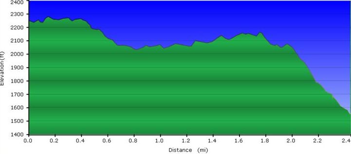
| Miles
|
Bays Ridge Trail
|
Miles
|
Elevation (ft)
|
| 0.0
|
Trailhead at Bays Ridge Road
|
2.6
|
2285
|
| 0.8
|
Junction with Jones Road at two splits. First leads out of park; second to the "Big Oak".
|
1.8
|
2090
|
| 2.1
|
Far end of the ridge crest
|
0.5
|
2095
|
| 2.6
|
Trailhead at Front Hollow Road
|
0.0
|
1615
|
Warning: The intersection at Jones Road is not marked. The roadway down to Front Hollow Road is at some graffiti. When heading back towards the Nature Center, the unmarked trail split is off the roadbed to the left continuing on the ridge crest.
Typical Conditions
Normally trail in good condition. Ridgeline through some briar patches, along rock outcroppings, and down a lesser used switchback. The path is usually covered with pine needles and/or fallen leaves. A few small blowdowns from recent storms, but can be stepped over or around.
Misc. Information
The "fireworks" you hear are the firearms being used at the Cherokee Rod and Gun Club located at the base of the ridge. There is at least one warning sign stating to not head SW off the trail.
Maps
Purple line is Bays Ridge Trail.
Loading map...
{"type":"TERRAIN","minzoom":false,"maxzoom":false,"types":["ROADMAP","SATELLITE","HYBRID","TERRAIN"],"mappingservice":"googlemaps3","width":"auto","height":"550px","centre":{"text":"","title":"","link":"","lat":36.49300000000000210320649784989655017852783203125,"lon":-82.635999999999995679900166578590869903564453125,"icon":""},"title":"","label":"","icon":"","lines":[],"polygons":[],"circles":[],"rectangles":[],"copycoords":false,"static":false,"visitedicon":"","wmsoverlay":false,"zoom":14,"layers":[],"controls":["pan","zoom","type","scale","streetview","rotate"],"zoomstyle":"DEFAULT","typestyle":"DEFAULT","autoinfowindows":false,"resizable":false,"kmlrezoom":false,"poi":true,"cluster":false,"clustergridsize":60,"clustermaxzoom":20,"clusterzoomonclick":true,"clusteraveragecenter":true,"clusterminsize":2,"imageoverlays":[],"kml":[],"gkml":["http://tehcc.org/clubwiki/kml/BMP_Front_Hollow_Road.kml","http://tehcc.org/clubwiki/kml/BMP_Bays_Ridge_Road.kml","http://tehcc.org/clubwiki/kml/BMP_Bays_Ridge_Trail.kml"],"searchmarkers":"","fullscreen":false,"scrollwheelzoom":false,"locations":[{"text":"\u003Cb\u003E\u003Cdiv class=\"mw-parser-output\"\u003E\u003Cp\u003ETrailhead at \u003Ca href=\"/wiki/Bays_Ridge_Road\" title=\"Bays Ridge Road\"\u003EBays Ridge Road\u003C/a\u003E\n\u003C/p\u003E\u003C/div\u003E\u003C/b\u003E\u003Cdiv class=\"mw-parser-output\"\u003E\u003Cp\u003E\u003Ca href=\"/wiki/File:BMP_Bays_Ridge_Trail_sign.JPG\" class=\"image\"\u003E\u003Cimg alt=\"BMP Bays Ridge Trail sign.JPG\" src=\"/clubwiki/images/thumb/BMP_Bays_Ridge_Trail_sign.JPG/50px-BMP_Bays_Ridge_Trail_sign.JPG\" decoding=\"async\" width=\"50\" height=\"33\" srcset=\"/clubwiki/images/thumb/BMP_Bays_Ridge_Trail_sign.JPG/75px-BMP_Bays_Ridge_Trail_sign.JPG 1.5x, /clubwiki/images/thumb/BMP_Bays_Ridge_Trail_sign.JPG/100px-BMP_Bays_Ridge_Trail_sign.JPG 2x\" data-file-width=\"448\" data-file-height=\"295\" /\u003E\u003C/a\u003E\n\u003C/p\u003E\u003C/div\u003E","title":"Trailhead at Bays Ridge Road\n","link":"","lat":36.4975639999999970086719258688390254974365234375,"lon":-82.6222489999999964993548928759992122650146484375,"icon":"/clubwiki/images/MarkerG.png"},{"text":"\u003Cdiv class=\"mw-parser-output\"\u003E\u003Cp\u003ETrailhead at \u003Ca href=\"/wiki/Front_Hollow_Road\" title=\"Front Hollow Road\"\u003EFront Hollow Road\u003C/a\u003E\n\u003C/p\u003E\u003C/div\u003E","title":"Trailhead at Front Hollow Road\n","link":"","lat":36.4869589999999988094714353792369365692138671875,"lon":-82.652118999999999005012796260416507720947265625,"icon":"/clubwiki/images/MarkerG.png"}]}
- The following elevation profile travels uphill from Front Hollow Road to Bays Ridge Road.
Photos

