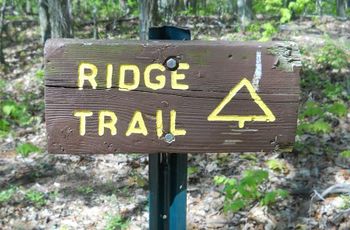
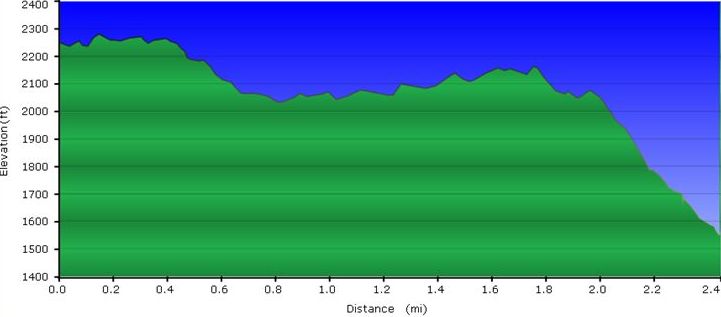
Loading map...
{"format":"googlemaps3","type":"TERRAIN","minzoom":false,"maxzoom":false,"types":["SATELLITE","HYBRID","TERRAIN"],"limit":50,"offset":0,"link":"none","sort":[""],"order":[],"headers":"show","mainlabel":"","intro":"","outro":"","searchlabel":"... further results","default":"","import-annotation":false,"width":"auto","height":"600px","centre":false,"title":"","label":"","icon":"","lines":[],"polygons":[],"circles":[],"rectangles":[],"copycoords":false,"static":false,"visitedicon":"","wmsoverlay":false,"zoom":false,"layers":[],"controls":["pan","zoom","type","scale","streetview","rotate"],"zoomstyle":"DEFAULT","typestyle":"DEFAULT","autoinfowindows":false,"resizable":false,"kmlrezoom":true,"poi":true,"cluster":false,"clustergridsize":60,"clustermaxzoom":20,"clusterzoomonclick":true,"clusteraveragecenter":true,"clusterminsize":2,"imageoverlays":[],"kml":[],"gkml":["https://tehcc.org/clubwiki/images/Bays_Ridge_Road.kml","https://tehcc.org/clubwiki/images/Bays_Ridge_Trail.kml","https://tehcc.org/clubwiki/images/Front_Hollow_Road.kml","https://tehcc.org/clubwiki/images/Jones_Road.kml"],"searchmarkers":"","fullscreen":false,"scrollwheelzoom":false,"showtitle":false,"hidenamespace":true,"template":"Map Balloon Template","userparam":"","activeicon":"","pagelabel":false,"ajaxcoordproperty":"","ajaxquery":"","locations":[{"text":"\u003Cp\u003E\u003Cb\u003E\u003Ca href=\"/wiki/Bays_Ridge_Road\" title=\"Bays Ridge Road\"\u003EBays Ridge Road\u003C/a\u003E\u003C/b\u003E\u003Cbr /\u003E\u003C/p\u003E\u003Chr /\u003E\u003Cp\u003E1.42\u0026#160;Mi (2.29\u0026#160;km)\u003Cbr /\u003EDifficulty: Medium\u003Cbr /\u003EMarking: Signs\u003C/p\u003E","title":"Bays Ridge Road","link":"","lat":36.5076499999999981582732289098203182220458984375,"lon":-82.6126000000000004774847184307873249053955078125,"icon":"/clubwiki/images/MarkerT.png"},{"text":"\u003Cp\u003E\u003Cb\u003EJunction with \u003Ca href=\"/wiki/Pine_Trail\" title=\"Pine Trail\"\u003EPine Trail\u003C/a\u003E\u003C/b\u003E\u003Cbr /\u003E\u003C/p\u003E\u003Chr /\u003E\u003Cp\u003EJunction with \u003Ca href=\"/wiki/Pine_Trail\" title=\"Pine Trail\"\u003EPine Trail\u003C/a\u003E\u003C/p\u003E","title":"Bays Ridge Road","link":"","lat":36.5063099999999991496224538423120975494384765625,"lon":-82.613110000000006039044819772243499755859375,"icon":"/clubwiki/images/MarkerG.png"},{"text":"\u003Cp\u003E\u003Cb\u003ERoad starts at \u003Ca href=\"/wiki/Lake_Road_(Bays_Mountain_Park)\" title=\"Lake Road (Bays Mountain Park)\"\u003ELake Road\u003C/a\u003E by reservoir dam\u003C/b\u003E\u003Cbr /\u003E\u003C/p\u003E\u003Chr /\u003E\u003Cp\u003E\u003Ca href=\"/wiki/File:BMP_LakeRd-BaysRidgeRd_sign.JPG\" class=\"image\"\u003E\u003Cimg alt=\"BMP LakeRd-BaysRidgeRd sign.JPG\" src=\"/clubwiki/images/thumb/BMP_LakeRd-BaysRidgeRd_sign.JPG/50px-BMP_LakeRd-BaysRidgeRd_sign.JPG\" decoding=\"async\" width=\"50\" height=\"179\" srcset=\"/clubwiki/images/thumb/BMP_LakeRd-BaysRidgeRd_sign.JPG/75px-BMP_LakeRd-BaysRidgeRd_sign.JPG 1.5x, /clubwiki/images/thumb/BMP_LakeRd-BaysRidgeRd_sign.JPG/100px-BMP_LakeRd-BaysRidgeRd_sign.JPG 2x\" data-file-width=\"125\" data-file-height=\"448\" /\u003E\u003C/a\u003E\u003C/p\u003E","title":"Bays Ridge Road","link":"","lat":36.50761299999999920373738859780132770538330078125,"lon":-82.6126579999999961501089273951947689056396484375,"icon":"/clubwiki/images/MarkerG.png"},{"text":"\u003Cp\u003E\u003Cb\u003ERoad starts at Ledbetter Gap\u003C/b\u003E\u003Cbr /\u003E\u003C/p\u003E\u003Chr /\u003E\u003Cp\u003E\u003Ca href=\"/wiki/File:BMP_Ledbetter_Gap_sign.JPG\" class=\"image\"\u003E\u003Cimg alt=\"BMP Ledbetter Gap sign.JPG\" src=\"/clubwiki/images/thumb/BMP_Ledbetter_Gap_sign.JPG/150px-BMP_Ledbetter_Gap_sign.JPG\" decoding=\"async\" width=\"150\" height=\"148\" srcset=\"/clubwiki/images/thumb/BMP_Ledbetter_Gap_sign.JPG/225px-BMP_Ledbetter_Gap_sign.JPG 1.5x, /clubwiki/images/thumb/BMP_Ledbetter_Gap_sign.JPG/300px-BMP_Ledbetter_Gap_sign.JPG 2x\" data-file-width=\"340\" data-file-height=\"336\" /\u003E\u003C/a\u003E\u003Cbr /\u003ECrossroads with \u003Ca href=\"/wiki/Lake_Road_(Bays_Mountain_Park)\" title=\"Lake Road (Bays Mountain Park)\"\u003ELake Road\u003C/a\u003E and \u003Ca href=\"/wiki/Front_Hollow_Road\" title=\"Front Hollow Road\"\u003EFront Hollow Road\u003C/a\u003E\u003C/p\u003E","title":"Bays Ridge Road","link":"","lat":36.4979000000000013415046851150691509246826171875,"lon":-82.627712999999999965439201332628726959228515625,"icon":"/clubwiki/images/MarkerG.png"},{"text":"\u003Cp\u003E\u003Cb\u003EJunction with \u003Ca href=\"/wiki/Orchid_Trail\" title=\"Orchid Trail\"\u003EOrchid Trail\u003C/a\u003E\u003C/b\u003E\u003Cbr /\u003E\u003C/p\u003E\u003Chr /\u003E\u003Cp\u003E\u003Ca href=\"/wiki/File:BMP_Orchid_Trail_sign2.JPG\" class=\"image\"\u003E\u003Cimg alt=\"BMP Orchid Trail sign2.JPG\" src=\"/clubwiki/images/thumb/BMP_Orchid_Trail_sign2.JPG/50px-BMP_Orchid_Trail_sign2.JPG\" decoding=\"async\" width=\"50\" height=\"109\" srcset=\"/clubwiki/images/thumb/BMP_Orchid_Trail_sign2.JPG/75px-BMP_Orchid_Trail_sign2.JPG 1.5x, /clubwiki/images/thumb/BMP_Orchid_Trail_sign2.JPG/100px-BMP_Orchid_Trail_sign2.JPG 2x\" data-file-width=\"206\" data-file-height=\"448\" /\u003E\u003C/a\u003E\u003C/p\u003E","title":"Bays Ridge Road","link":"","lat":36.5004899999999992132870829664170742034912109375,"lon":-82.6178599999999931924321572296321392059326171875,"icon":"/clubwiki/images/MarkerG.png"},{"text":"\u003Cp\u003E\u003Cb\u003E\u003Ca class=\"mw-selflink selflink\"\u003EBays Ridge Trail\u003C/a\u003E\u003C/b\u003E\u003Cbr /\u003E\u003C/p\u003E\u003Chr /\u003E\u003Cp\u003E2.38\u0026#160;Mi (3.83\u0026#160;km)\u003Cbr /\u003EDifficulty: Medium\u003Cbr /\u003EMarking: Signs\u003C/p\u003E","title":"Bays Ridge Trail","link":"","lat":36.49750999999999834244590601883828639984130859375,"lon":-82.6222900000000066711436375044286251068115234375,"icon":"/clubwiki/images/MarkerT.png"},{"text":"\u003Cp\u003E\u003Cb\u003ETrailhead at \u003Ca href=\"/wiki/Bays_Ridge_Road\" title=\"Bays Ridge Road\"\u003EBays Ridge Road\u003C/a\u003E\u003C/b\u003E\u003Cbr /\u003E\u003C/p\u003E\u003Chr /\u003E\u003Cp\u003E\u003Ca href=\"/wiki/File:BMP_Bays_Ridge_Trail_sign.JPG\" class=\"image\"\u003E\u003Cimg alt=\"BMP Bays Ridge Trail sign.JPG\" src=\"/clubwiki/images/thumb/BMP_Bays_Ridge_Trail_sign.JPG/50px-BMP_Bays_Ridge_Trail_sign.JPG\" decoding=\"async\" width=\"50\" height=\"33\" srcset=\"/clubwiki/images/thumb/BMP_Bays_Ridge_Trail_sign.JPG/75px-BMP_Bays_Ridge_Trail_sign.JPG 1.5x, /clubwiki/images/thumb/BMP_Bays_Ridge_Trail_sign.JPG/100px-BMP_Bays_Ridge_Trail_sign.JPG 2x\" data-file-width=\"448\" data-file-height=\"295\" /\u003E\u003C/a\u003E\u003C/p\u003E","title":"Bays Ridge Trail","link":"","lat":36.4975639999999970086719258688390254974365234375,"lon":-82.6222489999999964993548928759992122650146484375,"icon":"/clubwiki/images/MarkerG.png"},{"text":"\u003Cp\u003E\u003Cb\u003ETrailhead at \u003Ca href=\"/wiki/Front_Hollow_Road\" title=\"Front Hollow Road\"\u003EFront Hollow Road\u003C/a\u003E\u003C/b\u003E\u003Cbr /\u003E\u003C/p\u003E\u003Chr /\u003E\u003Cp\u003ETrailhead at \u003Ca href=\"/wiki/Front_Hollow_Road\" title=\"Front Hollow Road\"\u003EFront Hollow Road\u003C/a\u003E\u003C/p\u003E","title":"Bays Ridge Trail","link":"","lat":36.4869589999999988094714353792369365692138671875,"lon":-82.652118999999999005012796260416507720947265625,"icon":"/clubwiki/images/MarkerG.png"},{"text":"\u003Cp\u003E\u003Cb\u003E\u003Ca href=\"/wiki/Front_Hollow_Road\" title=\"Front Hollow Road\"\u003EFront Hollow Road\u003C/a\u003E\u003C/b\u003E\u003Cbr /\u003E\u003C/p\u003E\u003Chr /\u003E\u003Cp\u003E1.70\u0026#160;Mi (2.74\u0026#160;km)\u003Cbr /\u003EDifficulty: Medium\u003Cbr /\u003EMarking: Signs\u003C/p\u003E","title":"Front Hollow Road","link":"","lat":36.4978100000000011959855328314006328582763671875,"lon":-82.6276500000000027057467377744615077972412109375,"icon":"/clubwiki/images/MarkerT.png"},{"text":"\u003Cp\u003E\u003Cb\u003E\u003Ca href=\"/wiki/Jones_Road\" title=\"Jones Road\"\u003EJones Road\u003C/a\u003E\u003C/b\u003E\u003Cbr /\u003E\u003C/p\u003E\u003Chr /\u003E\u003Cp\u003E0.93\u0026#160;Mi (1.49\u0026#160;km)\u003Cbr /\u003EDifficulty: Medium\u003Cbr /\u003EMarking: Signs\u003C/p\u003E","title":"Jones Road","link":"","lat":36.49602999999999752844814793206751346588134765625,"lon":-82.6315900000000027603164198808372020721435546875,"icon":"/clubwiki/images/MarkerT.png"},{"text":"\u003Cp\u003E\u003Cb\u003EJunction with \u003Ca href=\"/wiki/Front_Hollow_Road\" title=\"Front Hollow Road\"\u003EFront Hollow Road\u003C/a\u003E by \"Big Oak\"\u003C/b\u003E\u003Cbr /\u003E\u003C/p\u003E\u003Chr /\u003E\u003Cp\u003E\u003Ca href=\"/wiki/File:BMP_Big_Oak.JPG\" class=\"image\"\u003E\u003Cimg alt=\"BMP Big Oak.JPG\" src=\"/clubwiki/images/thumb/BMP_Big_Oak.JPG/150px-BMP_Big_Oak.JPG\" decoding=\"async\" width=\"150\" height=\"200\" srcset=\"/clubwiki/images/thumb/BMP_Big_Oak.JPG/225px-BMP_Big_Oak.JPG 1.5x, /clubwiki/images/thumb/BMP_Big_Oak.JPG/300px-BMP_Big_Oak.JPG 2x\" data-file-width=\"768\" data-file-height=\"1024\" /\u003E\u003C/a\u003E\u003C/p\u003E","title":"Jones Road","link":"","lat":36.49602999999999752844814793206751346588134765625,"lon":-82.6315799999999995861799106933176517486572265625,"icon":"/clubwiki/images/MarkerT.png"},{"text":"\u003Cp\u003E\u003Cb\u003EParking at Bays Mountain Trail Road\u003C/b\u003E\u003Cbr /\u003E\u003C/p\u003E\u003Chr /\u003E\u003Cp\u003E\u003Ca href=\"/wiki/File:Jones_Road_Trailhead.jpg\" class=\"image\"\u003E\u003Cimg alt=\"Jones Road Trailhead.jpg\" src=\"/clubwiki/images/thumb/Jones_Road_Trailhead.jpg/150px-Jones_Road_Trailhead.jpg\" decoding=\"async\" width=\"150\" height=\"113\" srcset=\"/clubwiki/images/thumb/Jones_Road_Trailhead.jpg/225px-Jones_Road_Trailhead.jpg 1.5x, /clubwiki/images/thumb/Jones_Road_Trailhead.jpg/300px-Jones_Road_Trailhead.jpg 2x\" data-file-width=\"1200\" data-file-height=\"900\" /\u003E\u003C/a\u003E\u003C/p\u003E","title":"Jones Road","link":"","lat":36.49392374010000139605836011469364166259765625,"lon":-82.6241475613999938332199235446751117706298828125,"icon":"/clubwiki/images/MarkerA.png"},{"text":"\u003Cp\u003E\u003Cb\u003EJunction with \u003Ca class=\"mw-selflink selflink\"\u003EBays Ridge Trail\u003C/a\u003E\u003C/b\u003E\u003Cbr /\u003E\u003C/p\u003E\u003Chr /\u003E\u003Cp\u003E\u003Ca href=\"/wiki/File:Jones_Road_Junction_02.jpg\" class=\"image\"\u003E\u003Cimg alt=\"Jones Road Junction 02.jpg\" src=\"/clubwiki/images/thumb/Jones_Road_Junction_02.jpg/150px-Jones_Road_Junction_02.jpg\" decoding=\"async\" width=\"150\" height=\"113\" srcset=\"/clubwiki/images/thumb/Jones_Road_Junction_02.jpg/225px-Jones_Road_Junction_02.jpg 1.5x, /clubwiki/images/thumb/Jones_Road_Junction_02.jpg/300px-Jones_Road_Junction_02.jpg 2x\" data-file-width=\"1200\" data-file-height=\"900\" /\u003E\u003C/a\u003E\u003C/p\u003E","title":"Jones Road","link":"","lat":36.49210000000000064801497501321136951446533203125,"lon":-82.6337199999999967303665471263229846954345703125,"icon":"/clubwiki/images/MarkerT.png"},{"text":"\u003Cp\u003E\u003Cb\u003EArrives at ridgeline with \u003Ca class=\"mw-selflink selflink\"\u003EBays Ridge Trail\u003C/a\u003E\u003C/b\u003E\u003Cbr /\u003E\u003C/p\u003E\u003Chr /\u003E\u003Cp\u003E\u003Ca href=\"/wiki/File:Jones_Road_Junction_01.jpg\" class=\"image\"\u003E\u003Cimg alt=\"Jones Road Junction 01.jpg\" src=\"/clubwiki/images/thumb/Jones_Road_Junction_01.jpg/150px-Jones_Road_Junction_01.jpg\" decoding=\"async\" width=\"150\" height=\"113\" srcset=\"/clubwiki/images/thumb/Jones_Road_Junction_01.jpg/225px-Jones_Road_Junction_01.jpg 1.5x, /clubwiki/images/thumb/Jones_Road_Junction_01.jpg/300px-Jones_Road_Junction_01.jpg 2x\" data-file-width=\"1200\" data-file-height=\"900\" /\u003E\u003C/a\u003E\u003C/p\u003E","title":"Jones Road","link":"","lat":36.49276388909999724319277447648346424102783203125,"lon":-82.6321186832000051936120144091546535491943359375,"icon":"/clubwiki/images/MarkerT.png"},{"text":"\u003Cp\u003E\u003Cb\u003EView towards Black Mountains in NC\u003C/b\u003E\u003Cbr /\u003E\u003C/p\u003E\u003Chr /\u003E\u003Cp\u003E\u003Ca href=\"/wiki/File:Jones_Road_View_Towards_Black_Mountains.jpg\" class=\"image\"\u003E\u003Cimg alt=\"Jones Road View Towards Black Mountains.jpg\" src=\"/clubwiki/images/thumb/Jones_Road_View_Towards_Black_Mountains.jpg/150px-Jones_Road_View_Towards_Black_Mountains.jpg\" decoding=\"async\" width=\"150\" height=\"113\" srcset=\"/clubwiki/images/thumb/Jones_Road_View_Towards_Black_Mountains.jpg/225px-Jones_Road_View_Towards_Black_Mountains.jpg 1.5x, /clubwiki/images/thumb/Jones_Road_View_Towards_Black_Mountains.jpg/300px-Jones_Road_View_Towards_Black_Mountains.jpg 2x\" data-file-width=\"1200\" data-file-height=\"900\" /\u003E\u003C/a\u003E\u003C/p\u003E","title":"Jones Road","link":"","lat":36.4926119583000030388575396500527858734130859375,"lon":-82.6326353051999973331476212479174137115478515625,"icon":"/clubwiki/images/MarkerB.png"}]}
The path follows the base of the ridge. Meanders some to pass around deep muddy ruts and intersects with the creek.
Warning: The intersection at Jones Road is not marked. The roadway down to Front Hollow Road is at some graffiti. When heading back towards the Nature Center, the unmarked trail split is off the roadbed to the left continuing on the ridge crest.
Normally trail in good condition. Ridgeline through some briar patches, along rock outcroppings, and down a lesser used switchback. The path is usually covered with pine needles and/or fallen leaves. As of 2015 the blowdowns are cleaned up.
The "fireworks" you hear are the firearms being used at the Cherokee Rod and Gun Club located at the base of the ridge. There is at least one warning sign stating to not head SW off the trail.


