From the main parking lot, take Lake Road around to unmarked trailhead or jump on Big Oak for short distance for other trailhead.
The path meanders through the forest with planned switchbacks and bridge crossing.
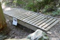
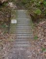
Hard packed trail with groove down the middle from the mountain bikes. Some rocks located at key spots. Several wood bridges constructed by BSA Troop 51.
Loading map...
{"type":"TERRAIN","minzoom":false,"maxzoom":false,"types":["ROADMAP","SATELLITE","HYBRID","TERRAIN"],"mappingservice":"googlemaps3","width":"auto","height":"500px","centre":{"text":"","title":"","link":"","lat":36.51400000000000289901436190120875835418701171875,"lon":-82.611999999999994770405464805662631988525390625,"icon":""},"title":"","label":"","icon":"","lines":[],"polygons":[],"circles":[],"rectangles":[],"copycoords":false,"static":false,"visitedicon":"","wmsoverlay":false,"zoom":15,"layers":[],"controls":["pan","zoom","type","scale","streetview","rotate"],"zoomstyle":"DEFAULT","typestyle":"DEFAULT","autoinfowindows":false,"resizable":false,"kmlrezoom":false,"poi":true,"cluster":false,"clustergridsize":60,"clustermaxzoom":20,"clusterzoomonclick":true,"clusteraveragecenter":true,"clusterminsize":2,"imageoverlays":[],"kml":[],"gkml":["http://tehcc.org/clubwiki/kml/BMP_Chinquapin_Trail.kml","http://tehcc.org/clubwiki/kml/BMP_lake_road.kml","http://tehcc.org/clubwiki/kml/BMP_Firetower_Trail.kml","http://tehcc.org/clubwiki/kml/BMP_Big_Oak_Trail.kml"],"searchmarkers":"","fullscreen":false,"scrollwheelzoom":false,"locations":[{"text":"\u003Cb\u003E\u003Cdiv class=\"mw-parser-output\"\u003E\u003Cp\u003ETrailhead at \u003Ca href=\"/clubwiki/index.php?title=Big_Oak\u0026amp;action=edit\u0026amp;redlink=1\" class=\"new\" title=\"Big Oak (page does not exist)\"\u003EBig Oak\u003C/a\u003E\n\u003C/p\u003E\u003C/div\u003E\u003C/b\u003E\u003Cdiv class=\"mw-parser-output\"\u003E\u003Cp\u003E\u003Ca href=\"/wiki/File:BMP_Big_Oak_-_Chinquapin_Trail_sign.JPG\" class=\"image\"\u003E\u003Cimg alt=\"BMP Big Oak - Chinquapin Trail sign.JPG\" src=\"/clubwiki/images/thumb/BMP_Big_Oak_-_Chinquapin_Trail_sign.JPG/50px-BMP_Big_Oak_-_Chinquapin_Trail_sign.JPG\" decoding=\"async\" width=\"50\" height=\"175\" srcset=\"/clubwiki/images/thumb/BMP_Big_Oak_-_Chinquapin_Trail_sign.JPG/75px-BMP_Big_Oak_-_Chinquapin_Trail_sign.JPG 1.5x, /clubwiki/images/thumb/BMP_Big_Oak_-_Chinquapin_Trail_sign.JPG/100px-BMP_Big_Oak_-_Chinquapin_Trail_sign.JPG 2x\" data-file-width=\"128\" data-file-height=\"448\" /\u003E\u003C/a\u003E\n\u003C/p\u003E\u003C/div\u003E","title":"Trailhead at Big Oak\n","link":"","lat":36.51451999999999742385625722818076610565185546875,"lon":-82.606009999999997717168298549950122833251953125,"icon":"/clubwiki/images/MarkerT.png"},{"text":"\u003Cb\u003E\u003Cdiv class=\"mw-parser-output\"\u003E\u003Cp\u003EJunction with \u003Ca href=\"/clubwiki/index.php?title=Firetower_Trail\u0026amp;action=edit\u0026amp;redlink=1\" class=\"new\" title=\"Firetower Trail (page does not exist)\"\u003EFiretower Trail\u003C/a\u003E\n\u003C/p\u003E\u003C/div\u003E\u003C/b\u003E\u003Cdiv class=\"mw-parser-output\"\u003E\u003Cp\u003E\u003Ca href=\"/wiki/File:BMP_FT-CQ_sign.JPG\" class=\"image\"\u003E\u003Cimg alt=\"BMP FT-CQ sign.JPG\" src=\"/clubwiki/images/thumb/BMP_FT-CQ_sign.JPG/50px-BMP_FT-CQ_sign.JPG\" decoding=\"async\" width=\"50\" height=\"220\" srcset=\"/clubwiki/images/thumb/BMP_FT-CQ_sign.JPG/75px-BMP_FT-CQ_sign.JPG 1.5x, /clubwiki/images/thumb/BMP_FT-CQ_sign.JPG/100px-BMP_FT-CQ_sign.JPG 2x\" data-file-width=\"102\" data-file-height=\"448\" /\u003E\u003C/a\u003E\n\u003C/p\u003E\u003C/div\u003E","title":"Junction with Firetower Trail\n","link":"","lat":36.5127600000000001045918907038867473602294921875,"lon":-82.61763999999999441570253111422061920166015625,"icon":"/clubwiki/images/MarkerT.png"},{"text":"\u003Cdiv class=\"mw-parser-output\"\u003E\u003Cp\u003ETrailhead at \u003Ca href=\"/wiki/Lake_Road_(Bays_Mountain_Park)\" title=\"Lake Road (Bays Mountain Park)\"\u003ELake Road\u003C/a\u003E\n\u003C/p\u003E\u003C/div\u003E","title":"Trailhead at Lake Road\n","link":"","lat":36.50950999999999879719325690530240535736083984375,"lon":-82.6213699999999988676790962927043437957763671875,"icon":"/clubwiki/images/MarkerT.png"},{"text":"\u003Cb\u003E\u003Cdiv class=\"mw-parser-output\"\u003E\u003Cp\u003ETrail bridge by Troop 51\n\u003C/p\u003E\u003C/div\u003E\u003C/b\u003E\u003Cdiv class=\"mw-parser-output\"\u003E\u003Cp\u003E\u003Ca href=\"/wiki/File:BMP_Chinquapin_Trail_bridge1.JPG\" class=\"image\"\u003E\u003Cimg alt=\"BMP Chinquapin Trail bridge1.JPG\" src=\"/clubwiki/images/thumb/BMP_Chinquapin_Trail_bridge1.JPG/150px-BMP_Chinquapin_Trail_bridge1.JPG\" decoding=\"async\" width=\"150\" height=\"101\" srcset=\"/clubwiki/images/thumb/BMP_Chinquapin_Trail_bridge1.JPG/225px-BMP_Chinquapin_Trail_bridge1.JPG 1.5x, /clubwiki/images/thumb/BMP_Chinquapin_Trail_bridge1.JPG/300px-BMP_Chinquapin_Trail_bridge1.JPG 2x\" data-file-width=\"448\" data-file-height=\"301\" /\u003E\u003C/a\u003E\n\u003C/p\u003E\u003C/div\u003E","title":"Trail bridge by Troop 51\n","link":"","lat":36.5152700000000010049916454590857028961181640625,"lon":-82.6072199999999980946085997857153415679931640625,"icon":"/clubwiki/images/MarkerL.png"},{"text":"\u003Cb\u003E\u003Cdiv class=\"mw-parser-output\"\u003E\u003Cp\u003ETrail bridge by Troop 51\n\u003C/p\u003E\u003C/div\u003E\u003C/b\u003E\u003Cdiv class=\"mw-parser-output\"\u003E\u003Cp\u003E\u003Ca href=\"/wiki/File:BMP_Chinquapin_Trail_bridge2.JPG\" class=\"image\"\u003E\u003Cimg alt=\"BMP Chinquapin Trail bridge2.JPG\" src=\"/clubwiki/images/thumb/BMP_Chinquapin_Trail_bridge2.JPG/150px-BMP_Chinquapin_Trail_bridge2.JPG\" decoding=\"async\" width=\"150\" height=\"192\" srcset=\"/clubwiki/images/thumb/BMP_Chinquapin_Trail_bridge2.JPG/225px-BMP_Chinquapin_Trail_bridge2.JPG 1.5x, /clubwiki/images/thumb/BMP_Chinquapin_Trail_bridge2.JPG/300px-BMP_Chinquapin_Trail_bridge2.JPG 2x\" data-file-width=\"336\" data-file-height=\"430\" /\u003E\u003C/a\u003E\n\u003C/p\u003E\u003C/div\u003E","title":"Trail bridge by Troop 51\n","link":"","lat":36.5126800000000031332092476077377796173095703125,"lon":-82.6187900000000041700332076288759708404541015625,"icon":"/clubwiki/images/MarkerL.png"},{"text":"","title":"","link":"","lat":36.51066999999999751480572740547358989715576171875,"lon":-82.6208299999999979945641825906932353973388671875,"icon":"/clubwiki/images/MarkerL.png"}]}