Chinquapin Trail: Difference between revisions
Jump to navigation
Jump to search
(Add unused photos) |
(update map and IB) |
||
| Line 1: | Line 1: | ||
<!-- The following few lines create the "Infobox" table template. Please scroll down to edit the main content of the article. --> | <!-- The following few lines create the "Infobox" table template. Please scroll down to edit the main content of the article. --> | ||
{{Infobox Trail | {{Infobox Trail | ||
| Image Name = BMP Chinquapin Trail.JPG | |||
| Park = Bays Mountain Park | |||
| City = Kingsport | |||
| State = Tennessee | |||
| Marking = Junction Signs | |||
| Trail Use = {{Hike}} {{Biking}} {{Dogs}} | |||
| Difficulty Rating = Easy | |||
| Hike Time = 60 Min | |||
| Round Trip Distance = 3.16 Mi | |||
| Trail Distance = 1.58 Mi | |||
| Trail Type = Segment | |||
| Elevation Gain = 575 Ft | |||
| Elevation Loss = -605 Ft | |||
| High Point = 2,055 Ft | |||
| Parking coords = 36.508821,-82.609545 | |||
| Trailhead coords = 36.514499,-82.606074 | |||
| Medical = Kingsport, TN | |||
}} | }} | ||
<!-- End Infobox template table--> | <!-- End Infobox template table--> | ||
<!-- Start of Main Page --> | <!-- Start of Main Page --> | ||
== Trail Overview == | == Trail Overview == | ||
<!-- Enter a overview of the trail. What attracts you to this trail, points of interest, types of flowers, lakes, and peaks that you see along the way. --> | <!-- Enter a overview of the trail. What attracts you to this trail, points of interest, types of flowers, lakes, and peaks that you see along the way. --> | ||
| Line 25: | Line 27: | ||
== How to get there == | == How to get there == | ||
<!-- Please enter detailed instruction on how to find the trail head. --> | <!-- Please enter detailed instruction on how to find the trail head. --> | ||
From the main parking lot, take Lake Road around to | From the main parking lot, take Lake Road around to Unmarked trailhead or jump on Big Oak for short distance for other trailhead. | ||
== Route Description== | == Route Description== | ||
<!-- Detailed description of the route. Is there any side trails that are worth traveling? --> | <!-- Detailed description of the route. Is there any side trails that are worth traveling? --> | ||
The path | The path meanders through the forest with planned switchbacks and bridge crossing. | ||
{| class="wikitable" border="1" | {| class="wikitable" border="1" | ||
| Line 59: | Line 61: | ||
== Maps == | == Maps == | ||
<!-- You can place pictures, PDF's, links, or even create a Google map with your waypoints and place it here. --> | <!-- You can place pictures, PDF's, links, or even create a Google map with your waypoints and place it here. --> | ||
< | <display_map center="36.514,-82.612" type="terrain" zoom="15" width="auto" height="500" gkml="http://tehcc.org/clubwiki/kml/BMP_Chinquapin_Trail.kml, | ||
http://tehcc.org/clubwiki/kml/BMP_Chinquapin_Trail.kml | http://tehcc.org/clubwiki/kml/BMP_lake_road.kml, | ||
http://tehcc.org/clubwiki/kml/BMP_lake_road.kml | http://tehcc.org/clubwiki/kml/BMP_Firetower_Trail.kml, | ||
http://tehcc.org/clubwiki/kml/BMP_Firetower_Trail.kml | http://tehcc.org/clubwiki/kml/BMP_Big_Oak_Trail.kml"> | ||
http://tehcc.org/clubwiki/kml/BMP_Big_Oak_Trail.kml | |||
</ | 36.51452,-82.60601~Trailhead at [[BMP Big Oak|Big Oak]]~[[Image:BMP Big Oak - Chinquapin Trail sign.JPG|50px]]~MarkerT.png | ||
36.51276,-82.61764~Junction with [[BMP Firetower Trail|Firetower Trail]]~[[Image:BMP FT-CQ sign.JPG|50px]]~MarkerT.png | |||
36.50951,-82.62137~Trailhead at [[BMP Lake Road|Lake Road]]~ ~MarkerT.png | |||
36.51527,-82.60722~Trail bridge by Troop 51~[[Image:BMP Chinquapin Trail bridge1.JPG|150px]]~MarkerL.png | |||
36.51268,-82.61879~Trail bridge by Troop 51~[[Image:BMP Chinquapin Trail bridge2.JPG|150px]]~MarkerL.png | |||
36.51067,-82.62083~ ~ ~MarkerL.png | |||
</display_map> | |||
== Photos == | == Photos == | ||
| Line 87: | Line 78: | ||
<!-- Place any pictures from this trail below. Ideally we would have a picture of the trailhead to help people know when they found it --> | <!-- Place any pictures from this trail below. Ideally we would have a picture of the trailhead to help people know when they found it --> | ||
<!-- Add a picture by typing Image:imagename.extension --> | <!-- Add a picture by typing Image:imagename.extension --> | ||
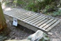
Image:BMP Chinquapin Trail bridge1.JPG| | Image:BMP Chinquapin Trail bridge1.JPG|Boy Scouts of America Built Bridge | ||
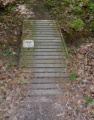
Image:BMP Chinquapin Trail bridge2.JPG| | Image:BMP Chinquapin Trail bridge2.JPG|Boy Scouts of America Built Bridge | ||
<!-- Do not remove the end gallery code.--> | <!-- Do not remove the end gallery code.--> | ||
</gallery> | </gallery> | ||
| Line 94: | Line 85: | ||
<!-- Finally add the trail to any Categories it should belong to. --> | <!-- Finally add the trail to any Categories it should belong to. --> | ||
[[Category:Tennessee]] [[Category:Kingsport]] [[Category:Bays Mountain Park]] [[Category:Easy]] [[Category:Hiking]] [[Category:Biking]] [[Category:Dog Friendly]] | [[Category:Tennessee]] [[Category:Kingsport]] [[Category:Bays Mountain Park]] [[Category:Easy]] [[Category:Hiking]] [[Category:Biking]] [[Category:Dog Friendly]] | ||
{{#set: | |||
|Trail page needs=Updated KML;Remove prefixes;Detail route description|+sep=; | |||
}} | |||
Revision as of 15:38, 2 October 2015
| |||||||||||||||||||||||||||||||||||||||||||||

Trail Overview
Located in Bays Mountain Park. New mountain biking trail constructed by the local club. Good for an easier ride or hike through hardwood forest dotted with hemlocks.
How to get there
From the main parking lot, take Lake Road around to Unmarked trailhead or jump on Big Oak for short distance for other trailhead.
Route Description
The path meanders through the forest with planned switchbacks and bridge crossing.
| Miles | Chinquapin Trail | Miles |
|---|---|---|
| 0.0 | Trailhead at Lake Road | 1.85 |
| 0.7 | Junction with Firetower Trail | 1.15 |
| 1.85 | Trailhead at Big Oak Trail | 0.0 |
Typical Conditions
Hard packed trail with groove down the middle from the mountain bikes. Some rocks located at key spots. Several wood bridges constructed by BSA Troop 51.
Misc. Information
Maps
Photos
Boy Scouts of America Built Bridge
Boy Scouts of America Built Bridge

