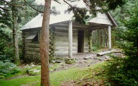
Shelter:Roan High Knob
Jump to navigation
Jump to search

| ||
| Shelter | Roan High Knob | |
| Capacity | 15 People | |
| Privy | No | |
| Trail Head Distance N | 0.1 Miles | |
| Trail Head Distance S | 0.1 Miles | |
| Elevation | 6,285 Feet | |
| Latitude | {{#lat_deg2dms: 36.10506}} | |
| Longitude | {{#long_deg2dms: -82.12222}} | |
| Nearest Medical | Elizabethton, TN | |
|
|
||
| Show Large Map | ||
Description[edit]
This is the highest elevation (6,285 ft) shelter on the entire AT. Originally the cabin for a fire warden who patrolled from a former fire tower that was nearby. Totally enclosed 450 sq ft as main room and loft.
Location[edit]
On the summit of Roan High Knob, between Carvers Gap and Hughes Gap. Reached on a 0.1 mile blue-blazed side trail.
Water[edit]
Spring is about 100 yards opposite shelter on blue-blazed side trail.
Maintenance History[edit]
- Oct 2018: Painted the front of the shelter to hide graffiti and cut off the bottom of the door so it would close better.
- Nov 2010: Trimmed bottom of door to allow it to open freely.
- 2007: Removed some rock underpinning and installed hardware cloth to improve ventilation, reworked some of foundation and patched roof.
- 2003: Installed cedar shingles on front and rear eaves, added cooking table against outside front wall, built railing upstairs around ladder opening, and coated outside with clear stain.
- Oct 2003: Patched the roof and fixing the porch overhang (jacking up and placing supporting rocks to avoid rot). The shelter support was previously non-existing, thus this action kept it from settling down the mountainside.
- 1999: Floor repaired by Boy Scouts.
- Dec 1996: Floor repaired by TEHCC of installing new plywood sheets.
- July 1980: Renovated to be an AT shelter by the Cherokee National Forest.
- 1934: Built by Forest Service.
Photo Gallery[edit]
| Shelter name | Section | Trail distance from Damascus |
|---|---|---|
| Abingdon Gap Shelter | US421 to Damascus | 10.2 |
| McQueens Knob Shelter (emergency shelter) | US421 to Damascus | 11.7 |
| Double Springs Shelter | TN91 to US421 | 18.5 |
| Iron Mountain Shelter | Wilbur Dam Rd to TN91 | 26.2 |
| Vandeventer Shelter | Wilbur Dam Rd to TN91 | 33.0 |
| Laurel Fork Shelter | Dennis Cove Rd to Wilbur Dam Rd | 49.5 |
| Moreland Gap Shelter | US19E to Dennis Cove Rd | 57.0 |
| Mountaineer Falls Shelter | US19E to Dennis Cove Rd | 66.6 |
| Stan Murray Shelter | Carver's Gap to US19E | 86.5 |
| Roan High Knob Shelter | Iron Mountain Gap to Carver's Gap | 91.7 |
| Clyde Smith Shelter | Iron Mountain Gap to Carver's Gap | 100.2 |
| Cherry Gap Shelter | Indian Grave Gap to Iron Mountain Gap | 109.3 |
| Curley Maple Gap Shelter | Nolichucky River to Indian Grave Gap | 122.2 |
| No Business Knob Shelter | Spivey Gap to Nolichucky River | 132.7 |
Per the 2021 AT Data Book.

