Pretty Ridge Trail
| Pretty Ridge Trail (log in to submit report) | |
|---|---|

| |
| Park | Bays Mountain Park |
| Land Owner | City of Kingsport |
| Located | Kingsport, Tennessee |
| Trail Marking | Signs |
| Trail UseThings allowed to do on or near the trail | |
| FeaturesThings to see on or near the trail |
|
| Difficulty Rating | Hard |
| Hiking TimeTime from car and back. Includes any time hiking to access this trail. | 1.5 hrs0.0938 Days <br />90 Min <br /> round trip |
| Distance: | 1.716 mi2.762 km <br /> trailStrict non-repeating trail length / 6.8 mi10.944 km <br /> round tripTypical or shortest length from the car, hike the trail, and return to car |
| Trail Type | Segment |
| Low / High Point | 1,608 ft536 Yards <br />490.118 Meters <br /> / 2,078 Ft692.667 Yards <br />633.374 Meters <br /> |
| Elev. Gain/LossSee link for details of calculation. Gain/Loss is direction dependent. | 386 Ft117.653 Meters <br /> / (461 Ft140.513 Meters <br />) – East-to-West |
| Trip ReportsFrom user "hiked it" submissions<br />Recent is within last 90 days | 1 logged hikes (0 recent) |
| NearbyWithin 5 mi<br />Click link to view list | 30 trails / 36.8 mi of trail |
| Parking | 36° 30' 31.75" N, 82° 36' 34.38" W Map |
| Trailhead | 36° 29' 51.50" N, 82° 38' 35.88" W Map |
|
| |
| Show In Google Maps | |
Download KML / Upload new version / KML File Page / Create Profile Chart / gpsvisualizer Map
Trail Overview[edit]
Located in Bays Mountain Park. Pretty Ridge, up on the ridge, is a nice extension of Indian Pipes Trail, but difficult hiking between Back Hollow Road.
How to get there[edit]
Take either Indian Pipes Trail from near Fire Tower or Back Hollow Road.
Route Description[edit]
On paper, a U-shaped path up from Back Hollow Road, along the ridgeline, and back down with connections to Back Hollow Road, Cross Ridges Trail, Indian Pipes Trail, Kiner Hollow Trail, Front Hollow Road, and Bays Ridge Trail. The trail is marked with white plastic blazes.
| Miles | Pretty Ridge Trail | Elevation (ft) |
|---|---|---|
| 0.00 | Back Hollow Road at abandoned cabin | 1672 |
| 0.45 | Intersection with Indian Pipes Trail and Kiner Hollow Trail | 1980 |
| 1.35 | Split back down just before meeting Kiner Hollow Trail again | 2000 |
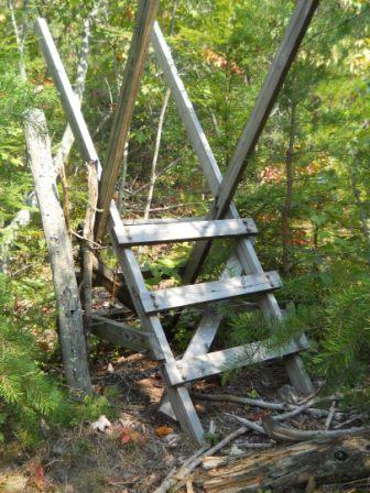
| 1.65 | Sty over fence | 1665 |
| 1.7 | Back Hollow Road at open meadows | 1615 |
Mountain biking is not allowed in the eastern drop down to Back Hollow Road. The western slope is inaccessible.
Typical Conditions[edit]
Nice hard dirt path up on the ridge. Eastern section was redug after a major winter storm in the 90s.
The western section from Back Hollow Road to the top of the ridgeline is cleaned up as of 2015. The trail is faint especially the middle part of the climb but you should be able to follow it. If you lose the trail just bushwhack uphill and you will reconnect to it back at the top anyway. It's a short climb and not hard either way. Blazes are sporadic still so keep an eye on your path. Not great but better than what is used to be.
Photos[edit]
