Fryingpan Mountain
| |||||||||||||||||||||||||||||||||||||

Trail Overview
Fryingpan Mountain (5,340 ft.) is in the Pisgah Ranger District southwest of Asheville NC. It's noticeable feature is a 70ft fire tower on its summit. It is the tallest fire tower in the entire state of North Carolina.
Get the same and arguably better views as nearby Mount Pisgah but with a much easier hike and far less crowds. This is a great short family hike but the fire tower itself can be a little intimidating to climb.
The cab of the fire tower is locked but you can take the old metal stairs to just below it and get stunning 360 degree views. There are communication towers on the summit as well but they don't really interfere with the view.
The fire tower has views of the entire Balsam Mountains range. It has a close-up view of famous Cold Mountain which is just a mere 5 miles north. Looking Glass Rock and Mount Pisgah are not that far away either. The Great Smoky Mountains National Park is visible as well.
How to get there
Google Maps Driving Directions
Route Description
You park at the entrance to the Forest Service Road 450, at Milepost 409.6 on the Blue Ridge Parkway. Do not block the road or the gate. Just walk up the .75 mile gravel road to the summit.
Typical Conditions
- Gravel forest service road
- Smooth and wide
- Great for groups and families
- Uphill the entire way but never steep
Fees, Permits, etc.
After the Hike
Misc. Information
Maps
Photos
-
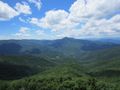 View towards Cold Mountain
 -
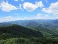
 View towards Mount Pisgah
 -
 View towards Looking Glass Rock
 -
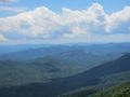
 View towards the Balsam Mountains and Shining Rock
 -
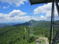
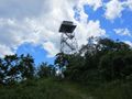 71 foot fire tower on the mountain summit. Highest in North Carolina


