Cross Ridges Trail
| |||||||||||||||||||||||||||||||||||||||||||||

Trail Overview
Located in Bays Mountain Park. Trail between Front Hollow Road and Back Hollow Road. Lots of spring wildflowers on northern side in the shaded hollow.
How to get there
The trail is not directly accessible from the main parking lot. Cross the dam and take either Follow Lake Road to Front Hollow Road until reaching trail sign or Lake Road to Feagins Gap and onto Back Hollow Road until old homestead is seen.
Route Description
A 0.7 mile connecting trail between the "Hollow" roads.
This trail has connections to Back Hollow Road, Pretty Ridge Trail, Cherry Knobs Road, and Front Hollow Road.
| Miles | Cross Ridges Trail | Miles | Elevation (ft) |
|---|---|---|---|
| 0.0 | Trailhead at Front Hollow Road | 0.7 | 1730 |
| 0.2 | Junction with Cherry Knobs Trail | 0.5 | 1840 |
| 0.65 | Creek crossing with no bridge | 0.05 | |
| 0.7 | Junction at Back Hollow Road and Pretty Ridge Trail at former "Bill Simpson" homestead | 0.0 | 1672 |
Back Hollow Road continues towards Feagins Gap from right and behind the abandoned cabin. Pretty Ridge Trail has an unlabeled post, but heads uphill from left of the cabin. A fallen pine tree was partially covering this junction.
Typical Conditions
Much lesser used trail. As of 2015, trail is cleaned up and most blowdowns removed. The two remaining are easy to step over.
Regulations
NO BIKES! And too much trouble with all of the blowdowns anyway.
Misc. Information
Many spring wildflowers seen in April. Check out the gallery below.
Maps
The track for Cross Ridges Trail is in red, while Cherry Knobs Trail is shown in green.
- The following elevation profile travels from Back Hollow Road to Front Hollow Road.

Photos
-
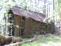
Trail ends just past "Bill Simpson" barn
-
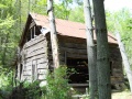
Bill Simpson Cabin

Wildflower Gallery - mid-April 2011


