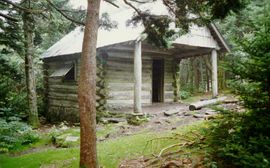
Shelter:Roan High Knob
Revision as of 07:50, 12 October 2014 by Vhasler (talk | contribs) (→Maintenance History: Added 1999 entry per LMP)

| ||
| Shelter | Roan High Knob | |
| Capacity | 15 People | |
| Privy | No | |
| Trail Head Distance N | 0.1 Miles | |
| Trail Head Distance S | 0.1 Miles | |
| Elevation | 6,285 Feet | |
| Latitude | {{#lat_deg2dms: 36.10506}} | |
| Longitude | {{#long_deg2dms: -82.12222}} | |
| Nearest Medical | Elizabethton, TN | |
|
|
||
| Show Large Map | ||
Description
This is the highest elevation (6,285 ft) shelter on the entire AT. Originally the cabin for a fire warden who patrolled from a former fire tower that was nearby. Totally enclosed 450 sq ft as main room and loft.
Location
On the summit of Roan High Knob, between Carvers Gap and Hughes Gap. Reached on a 0.1 mile blue-blazed side trail.
Water
Spring is about 100 yards opposite shelter on blue-blazed side trail.
Maintenance History
- Nov 2010: Trimmed bottom of door to allow it to open freely.
- 2007: Removed some rock underpinning and installed hardware cloth to improve ventilation, reworked some of foundation and patched roof.
- 2003: Installed cedar shingles on front and rear eaves, added cooking table against outside front wall, built railing upstairs around ladder opening, and coated outside with clear stain.
- Oct 2003: Patched the roof and fixing the porch overhang (jacking up and placing supporting rocks to avoid rot). The shelter support was previously non-existing, thus this action kept it from settling down the mountainside.
- 1999: Floor repaired by Boy Scouts.
- Dec 1996: Floor repaired by TEHCC of installing new plywood sheets.
- July 1980: Renovated to be an AT shelter by the Cherokee National Forest.
- 1934: Built by Forest Service.
Photo Gallery
| Shelter name | Section | Trail distance from Damascus |
|---|---|---|
| Abingdon Gap Shelter | US421 to Damascus | 10.2 |
| McQueens Knob Shelter (emergency shelter) | US421 to Damascus | 11.7 |
| Double Springs Shelter | TN91 to US421 | 18.5 |
| Iron Mountain Shelter | Wilbur Dam Rd to TN91 | 26.2 |
| Vandeventer Shelter | Wilbur Dam Rd to TN91 | 33.0 |
| Laurel Fork Shelter | Dennis Cove Rd to Wilbur Dam Rd | 49.5 |
| Moreland Gap Shelter | US19E to Dennis Cove Rd | 57.0 |
| Mountaineer Falls Shelter | US19E to Dennis Cove Rd | 66.6 |
| Stan Murray Shelter | Carver's Gap to US19E | 86.5 |
| Roan High Knob Shelter | Iron Mountain Gap to Carver's Gap | 91.7 |
| Clyde Smith Shelter | Iron Mountain Gap to Carver's Gap | 100.2 |
| Cherry Gap Shelter | Indian Grave Gap to Iron Mountain Gap | 109.3 |
| Curley Maple Gap Shelter | Nolichucky River to Indian Grave Gap | 122.2 |
| No Business Knob Shelter | Spivey Gap to Nolichucky River | 132.7 |
Per the 2021 AT Data Book.

