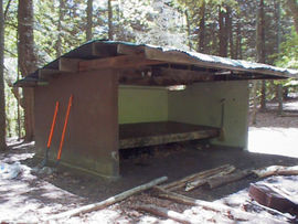
Shelter:Moreland Gap
Jump to navigation
Jump to search

| ||
| Shelter | {{{Shelter}}} | |
| Capacity | 6 People | |
| Privy | No | |
| Trail Head Distance N | {{{DistanceN}}} Miles | |
| Trail Head Distance S | {{{DistanceS}}} Miles | |
| Elevation | 3,813 Feet | |
| Latitude | {{#lat_deg2dms: 36.22021}} | |
| Longitude | {{#long_deg2dms: -82.088362}} | |
| Nearest Medical | Elizabethton, TN | |
|
|
||
| Show Large Map | ||
Description
Basic three-sided concrete block shelter with open front and wooden sleeping platform.
Location
Directly on the AT; up on White Rocks Mountain between Dennis Cove Road and US19E.
Water
A spring is located down the hollow opposite the shelter.
Maintenance History
- Feb 2008: Fix water source after someone tore out the drain line.
- Sept 2005: Improve water supply by installing drain line and bucket reservoir.
- Nov 1996: Cleaned and painted the shelter roof.
- 1994: Installed picnic table.
- 1960: Built by US Forest Service.
Photo Gallery
| Shelter name | Section | Trail distance from Damascus |
|---|---|---|
| Abingdon Gap Shelter | US421 to Damascus | 10.2 |
| McQueens Knob Shelter (emergency shelter) | US421 to Damascus | 11.7 |
| Double Springs Shelter | TN91 to US421 | 18.5 |
| Iron Mountain Shelter | Wilbur Dam Rd to TN91 | 26.2 |
| Vandeventer Shelter | Wilbur Dam Rd to TN91 | 33.0 |
| Laurel Fork Shelter | Dennis Cove Rd to Wilbur Dam Rd | 49.5 |
| Moreland Gap Shelter | US19E to Dennis Cove Rd | 57.0 |
| Mountaineer Falls Shelter | US19E to Dennis Cove Rd | 66.6 |
| Stan Murray Shelter | Carver's Gap to US19E | 86.5 |
| Roan High Knob Shelter | Iron Mountain Gap to Carver's Gap | 91.7 |
| Clyde Smith Shelter | Iron Mountain Gap to Carver's Gap | 100.2 |
| Cherry Gap Shelter | Indian Grave Gap to Iron Mountain Gap | 109.3 |
| Curley Maple Gap Shelter | Nolichucky River to Indian Grave Gap | 122.2 |
| No Business Knob Shelter | Spivey Gap to Nolichucky River | 132.7 |
Per the 2021 AT Data Book.

