Pretty Ridge Trail: Difference between revisions
m (Changed Difficult to Hard to match categorization plan) |
(Update IB to new format) |
||
| Line 1: | Line 1: | ||
<!-- The following few lines create the "Infobox" table template. Please scroll down to edit the main content of the article. --> | <!-- The following few lines create the "Infobox" table template. Please scroll down to edit the main content of the article. --> | ||
{{Infobox Trail | {{Infobox Trail | ||
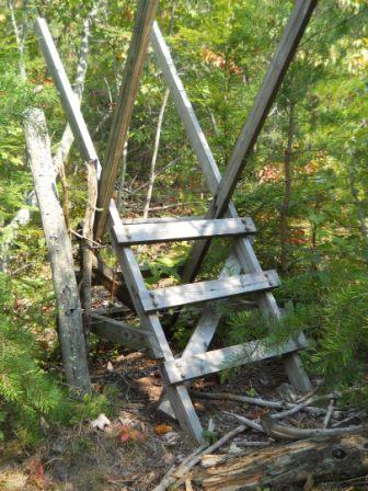
| Image Name = | | Image Name = BMP Pretty Ridge Trail sty.JPG | ||
| City = Kingsport | | City = Kingsport | ||
| State = Tennessee | | State = Tennessee | ||
| Marking = Junction Signs | |||
| Trail Use = {{Hike}} {{Biking}} {{Dogs}} | | Trail Use = {{Hike}} {{Biking}} {{Dogs}} | ||
| Difficulty Rating = Hard | | Difficulty Rating = Hard | ||
| Line 10: | Line 11: | ||
| Elevation Gain = ~470 | | Elevation Gain = ~470 | ||
| High Point = 2081 | | High Point = 2081 | ||
| Latitude = | | Latitude = 36.49487 | ||
| Longitude = | | Longitude = -82.60517 | ||
| Medical = Kingsport, TN | | Medical = Kingsport, TN | ||
}} | }} | ||
<!-- End Infobox template table--> | <!-- End Infobox template table--> | ||
| Line 82: | Line 77: | ||
http://tehcc.org/clubwiki/kml/BMP_Pretty_Ridge_Trail.kml | http://tehcc.org/clubwiki/kml/BMP_Pretty_Ridge_Trail.kml | ||
http://tehcc.org/clubwiki/kml/BMP_Indian_Pipes_Trail.kml | http://tehcc.org/clubwiki/kml/BMP_Indian_Pipes_Trail.kml | ||
(G) 36.491574,-82.657148 | (G) 36.491574,-82.657148 | ||
Revision as of 22:23, 30 May 2012
| |||||||||||||||||||||||||||||||||||||
Trail Overview
Located in Bays Mountain Park. Pretty Ridge, up on the ridge, is a nice extension of Indian Pipes Trail, but difficult hiking between Back Hollow Road.
How to get there
Take either Indian Pipes Trail from near Firetower or Back Hollow Road.
Route Description
On paper, a U-shaped path up from Back Hollow Road, along the ridgeline, and back down. The western segment has been abandoned by the park at this time. White plastic blazes.
| Miles | Pretty Ridge Trail | Elevation (ft) |
|---|---|---|
| 0.00 | Back Hollow Road at abandoned cabin | 1672 |
| 0.45 | Intersection with Indian Pipes Trail and Kiner Hollow Trail | 1980 |
| 1.35 | Split back down just before meeting Kiner Hollow Trail again | 2000 |
| 1.65 | Sty over fence | 1665 |
| 1.7 | Back Hollow Road at open meadows | 1615 |
Mountain biking is not allowed in the eastern drop down to Back Hollow Road. The western slope is inaccessible.
Typical Conditions
Nice hard dirt path up on the ridge. Eastern section was redug after a major winter storm in the 90s. The western section has been abandoned by the park after 2009 winter storms with many, many blowdowns and missing blazes, thus no maintenance being done.
Misc. Information
Maps
Brown is Pretty Ridge Trail. Yellow is Kiner Hollow Trail. Red is Indian Pipes Trail. Green is Back Hollow Road.
<googlemap version="0.9" lat="36.4949" lon="-82.65" type="terrain" zoom="15" width="725" scale="yes" icons="http://tehcc.org/clubwiki/kml/marker{label}.png"> http://tehcc.org/clubwiki/kml/BMP_Back_Hollow_Road.kml http://tehcc.org/clubwiki/kml/BMP_Kiner_Hollow_Trail.kml http://tehcc.org/clubwiki/kml/BMP_Pretty_Ridge_Trail.kml http://tehcc.org/clubwiki/kml/BMP_Indian_Pipes_Trail.kml
(G) 36.491574,-82.657148
Western descent from ridge
(G) 36.4976,-82.6433
Intersection at Back Hollow Road
36.48915,-82.65420
Sty across fence


