Roan Mountain State Park: Difference between revisions
(→Photos: add water wheel) |
(→Park Overview: update overview) |
||
| (16 intermediate revisions by 2 users not shown) | |||
| Line 1: | Line 1: | ||
{{Park | |||
{{ | |Banner Image=File:Roan Miller Homestead.jpg | ||
|Park Type=State Park | |||
|Park Website=https://tnstateparks.com/parks/roan-mountain | |||
|Trail Map Link=http://tnstateparks.com/assets/pdf/additional-content/park-maps/roan-mountain_park-map.pdf | |||
|Entrance Fee Type=None | |||
|Activities=Hiking, Biking, Geocaching, Fishing | |||
|Features=Vistas, Rivers | |||
|Park Amenities=Pools, Fast Food Grill, Picnicking, Playgrounds | |||
|Lodging Types=Cabins, Campground, Group Campground | |||
|Camping Amenities=Site water, Dump station, 20 amp electrical, 30 amp electrical, Tent only, Showers, Clothes Washing, Playgrounds, Wi-Fi, Camp Store | |||
|City=Roan Mountain | |||
|Area=2,006 acres | |||
|Operated By=Tennessee Department of Environment and Conservation | |||
|Main Location=36.17654, -82.0794 | |||
}} | }} | ||
{{Park trail map}} | |||
== Park Overview == | __TOC__ | ||
[http://tnstateparks.com/parks/about/roan-mountain Roan Mountain State Park] offers {{Park trail count}} trails with a total of {{Park trail miles}} of hiking trails running through forest and some up to overlooks. | ==Park Overview== | ||
[http://tnstateparks.com/parks/about/roan-mountain Roan Mountain State Park] offers {{Park trail count|Park={{PAGENAME}}}} trails with a total of {{Park trail miles|Park={{PAGENAME}}}} of hiking trails running through forest and some up to overlooks. This park doesn't have the greatest trails, probably nothing I would recommend traveling to simply for the hiking. Where this park shines is its campground and serving as a great jumping off point to the hiking in the Roan Highlands. Also of great attraction are the rallies held here throughout the year offering both youth and adult focus. | |||
== How to get there == | == How to get there == | ||
| Line 27: | Line 32: | ||
== Park Trails == | == Park Trails == | ||
There are several discrepancies between the park trail map, posted trail lengths, and GPS measured hikes. This wiki lists the GPS tracked hike. | |||
{{Park trail | {{PAGENAME}} has the following {{Park trail count}} trails totaling {{Park trail miles}}. | ||
{{Park trail table}} | |||
[http://tnstateparks.com/assets/pdf/additional-content/park-maps/roan-mountain_park-map.pdf Official Park Map] | [http://tnstateparks.com/assets/pdf/additional-content/park-maps/roan-mountain_park-map.pdf Official Park Map] | ||
| Line 38: | Line 44: | ||
=== Campground === | === Campground === | ||
Camp store sells wood, ice, and some very basic other sundries. The main RV area is blanketed with Wi-Fi but when visiting in Summer of 2015, couldn't be accessed. Several bathhouses are spread around the site and include hot showers. A dump station for RV's is also available near the camp check-in station. | Camp store sells wood, ice, and some very basic other sundries. The main RV area is blanketed with Wi-Fi but when visiting in Summer of 2015, couldn't be accessed. Several bathhouses are spread around the site and include flushing toilets and hot showers. A dump station for RV's is also available near the camp check-in station. | ||
[[File:Roan tent only site.jpg|right|250px|thumb|Typical tent only site]]Tent only sites are built on a course gravel bed so bring your tarps to protect your tent floor and sleeping pads or mattresses for comfort. Each site includes a lantern post, a concrete picnic table, rock lined fire ring, standing grill, water hydrant, and trash can. Note that the tent only sites do not have electrical hookups. | [[File:Roan tent only site.jpg|right|250px|thumb|Typical tent only site]]Tent only sites are built on a course gravel bed so bring your tarps to protect your tent floor and sleeping pads or mattresses for comfort. Each site includes a lantern post, a concrete picnic table, rock lined fire ring, standing grill, water hydrant, and trash can. Note that the tent only sites do not have electrical hookups. | ||
| Line 50: | Line 56: | ||
==Other Park Amenities== | ==Other Park Amenities== | ||
*Pool | * Pool | ||
*Playgrounds | * Playgrounds | ||
*Amphitheater | * Amphitheater | ||
*Conference center | * Conference center | ||
*Picnic areas | * Picnic areas | ||
*Pavilions | * Pavilions | ||
* Tennis courts | |||
* Shuffle board - in state of disrepair | |||
* Volleyball court | |||
==Fees, Permits, etc. == | ==Fees, Permits, etc. == | ||
The park has no day use, trail head, or entrance fees. | The park has no day use, trail head, or entrance fees. | ||
| Line 67: | Line 75: | ||
== Misc. Information == | == Misc. Information == | ||
<!-- Enter any additional information that doesn't fit an any other fields. Any seasonal features, factoids, etc...? --> | <!-- Enter any additional information that doesn't fit an any other fields. Any seasonal features, factoids, etc...? --> | ||
The house at the Miller Homestead was built in 1908 by Nathanial Miller and eventually became the home of his family of wife Sallie and their six children (Eula, Frank, David, Steward, Lloyd, and Carrie). Frank Miller was a State Park on-site interpreter for a time before his death. | |||
== After the Hike == | == After the Hike == | ||
| Line 72: | Line 81: | ||
After a hike, check out Bob's Dairyland back down in Roan Mountain. | After a hike, check out Bob's Dairyland back down in Roan Mountain. | ||
== | ==Gallery== | ||
{{Park trail gallery|Park={{PAGENAME}}}} | |||
Latest revision as of 21:44, 22 December 2019
| Roan Mountain State Park | |
|---|---|

| |
| Park Type | State Park |
| Located | Roan Mountain, Tennessee |
| External Links | Official Website |
| Entrance Fee | None |
| ActivitiesThings to do at the park | |
| Park AmenitiesThings built to enjoy or use at the park | |
| FeaturesNatural things to see at the park | |
| Park Trails |
11 Trails / Total of 12.67 miles20.39 km <br /> |
| Lodging Types | |
| Camping Amenities | |
| Park Area | 2,006 acres8.118 km² <br /> |
| Operated By | Tennessee Department of Environment and Conservation |
| Main Location | 36° 10' 35.54" N, 82° 4' 45.84" W Map |
|
| |
| Show In Google Maps | |
Download KML / Upload new version / KML File Page
Park Overview[edit]
Roan Mountain State Park offers 11 trails with a total of 12.67 miles of hiking trails running through forest and some up to overlooks. This park doesn't have the greatest trails, probably nothing I would recommend traveling to simply for the hiking. Where this park shines is its campground and serving as a great jumping off point to the hiking in the Roan Highlands. Also of great attraction are the rallies held here throughout the year offering both youth and adult focus.
How to get there[edit]
From Johnson City (I-26 Exit 24):
- Take TN67/US321 over to Elizabethton (about eight miles).
- Turn right/south at traffic light for TN37/US19E/US321 and travel for 17 miles.
- Turn right/south for TN143 for five miles to park visitors center.
- Trailheads are in several places around the park.
GPS address is 1015 Hwy 143 Roan Mountain, TN 37687.
Park Trails[edit]
There are several discrepancies between the park trail map, posted trail lengths, and GPS measured hikes. This wiki lists the GPS tracked hike.
Roan Mountain State Park has the following 11 trails totaling 12.67 miles.
| Park Trails | Distance | Difficulty | Marking | Usage | Highlight |
|---|---|---|---|---|---|
| Blue 2 | 1.51 mi | Medium | Blue | One of the two trail mountain bike system at the park | |
| Chestnut Ridge | 2.19 mi | Medium | Orange | ||
| Cloudland | 0.62 mi | Easy | Light Blue | Self guided visitor's trail from the visitor's center/grist mill | |
| Forest Road | 3.22 mi | Medium | Purple | ||
| Fred Behrend | 2.20 mi | Medium | Green | Loop hike from the campground | |
| Peg Leg Mine | 0.28 mi | Easy | White | View the entrance to an abandoned mine | |
| Raven Rock | 0.97 mi | Medium | Red | Easy(ish) hike from the campground to a view of the hollow | |
| Ridge Top | 0.23 mi | Easy | Yellow | One of the two trail mountain bike system at the park | |
| Riverside | 0.57 mi | Easy | White | Easy, handicap accessible, trail along Doe River | |
| Tom Gray | 0.47 mi | Easy | White | Easy hike from the campground | |
| Turkey Trot | 0.41 mi | Medium | Red | Connects the cabins to the trail artery Forest Road |
Park Lodging[edit]
Park offers RV sites, tent only sites as well as cabins. Sites fill up quickly on most summer weekends. It is ill advised to arrive without a reservation in the summer.
Campground[edit]
Camp store sells wood, ice, and some very basic other sundries. The main RV area is blanketed with Wi-Fi but when visiting in Summer of 2015, couldn't be accessed. Several bathhouses are spread around the site and include flushing toilets and hot showers. A dump station for RV's is also available near the camp check-in station.
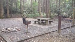
Tent only sites are built on a course gravel bed so bring your tarps to protect your tent floor and sleeping pads or mattresses for comfort. Each site includes a lantern post, a concrete picnic table, rock lined fire ring, standing grill, water hydrant, and trash can. Note that the tent only sites do not have electrical hookups.
Camp sites of special note:
- 22 & 38 have no tree block separating them (good for groups, bad for others)
- 26 is next to a bathroom with a light and fan on all night
- 33, 35, 36, 37, 39, and 40 are prime sites along the Doe River
Note! As a state park, alcoholic beverages are prohibited.
Other Park Amenities[edit]
- Pool
- Playgrounds
- Amphitheater
- Conference center
- Picnic areas
- Pavilions
- Tennis courts
- Shuffle board - in state of disrepair
- Volleyball court
Fees, Permits, etc.[edit]
The park has no day use, trail head, or entrance fees.
Camping fees range from $11-$27.50 per night depending on time of year and site amenities plus a $3 per reservation fee and taxes. Reservations can be made at their website.
Cabins range from $85 — $140 per night depending on size and time of year plus a $3 per reservation fee and taxes. Reservations can be made at their website.
Misc. Information[edit]
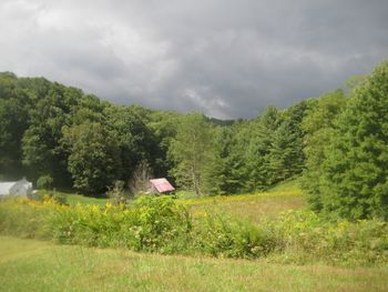
The house at the Miller Homestead was built in 1908 by Nathanial Miller and eventually became the home of his family of wife Sallie and their six children (Eula, Frank, David, Steward, Lloyd, and Carrie). Frank Miller was a State Park on-site interpreter for a time before his death.
After the Hike[edit]
After a hike, check out Bob's Dairyland back down in Roan Mountain.


