Cloudland (Roan Mountain State Park)
| Cloudland (Roan Mountain State Park) (log in to submit report) | |
|---|---|

| |
| Highlight | Self guided visitor's trail from the visitor's center/grist mill |
| Park | Roan Mountain State Park |
| Located | Roan Mountain, TennesseeLocation inherited from associated park |
| Trail Marking | Light Blue |
| Trail UseThings allowed to do on or near the trail |
|
| FeaturesThings to see on or near the trail |
|
| Difficulty Rating | Easy |
| Hiking TimeTime from car and back. Includes any time hiking to access this trail. | 1.5 hrs0.0938 Days <br />90 Min <br /> round trip |
| Distance: | 0.6194 mi0.997 km <br /> trailStrict non-repeating trail length / 0.6194 mi0.997 km <br /> round tripTypical or shortest length from the car, hike the trail, and return to car |
| Trail Type | Loop |
| Low / High Point | 2,673 ft891 Yards <br />814.73 Meters <br /> / 2,806 ft935.333 Yards <br />855.269 Meters <br /> |
| Elev. Gain/LossSee link for details of calculation. Gain/Loss is direction dependent. | 107 ft32.614 Meters <br /> / (110 ft33.528 Meters <br />) – Counter Clockwise |
| Trip ReportsFrom user "hiked it" submissions<br />Recent is within last 90 days | No hikes logged yet |
| NearbyWithin 5 mi<br />Click link to view list | 11 trails / 49.8 mi of trail |
| Parking | 36° 10' 35.54" N, 82° 4' 45.84" W Map |
| Trailhead | 36° 10' 34.79" N, 82° 4' 44.83" W Map |
|
| |
| Show In Google Maps | |
Download KML / Upload new version / KML File Page / Create Profile Chart / gpsvisualizer Map
Trail Overview
A self guided nature trail within the Roan Mountain State Park trail system. If you're driving through, or not a big hiker, take this short hike to stretch your legs and enjoy some nature for about 15-30 minutes.
How to get there
The trail begins behind the Visitor Center to the right. The described hike is counter-clockwise and begins at the rear of the cleared area and starts by following the Doe River.
Route Description

Short trail beginning at the Visitor Center. Begin by following the Doe River upstream before turning up the ridge for some higher elevation hiking.
| Miles Out | Cloudland Trail | Miles Back | Elevation (ft) |
|---|---|---|---|
| 0.0 | At Visitor's Center | 0.66 | 2,719 |
| 0.20 | Large rock | 0.46 | 2,755 |
| 0.31 | At Parking lot | 0.35 | 2,788 |
| 0.66 | Return to Visitor's Center | 0.00 | 2,719 |
Typical Conditions
The hike is fairly level with some minor elevation changes. Drainage streams are typically covered with short walking bridges. Some portions of the trail can be uneven and rocky.
Photos
-
 Trail Profile
 -
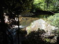 Doe River
 -
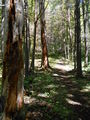 Trail View
