Riverside
| Riverside (log in to submit report) | |
|---|---|

| |
| Highlight | Easy, handicap accessible, trail along Doe River |
| Park | Roan Mountain State Park |
| Located | Roan Mountain, TennesseeLocation inherited from associated park |
| Trail Marking | White |
| Trail UseThings allowed to do on or near the trail |
|
| FeaturesThings to see on or near the trail |
|
| Difficulty Rating | Easy |
| Hiking TimeTime from car and back. Includes any time hiking to access this trail. | 60 min1 Hours <br />0.0625 Days <br /> round trip |
| Distance: | 0.5736 mi0.923 km <br /> trailStrict non-repeating trail length / 1.18 mi1.899 km <br /> round tripTypical or shortest length from the car, hike the trail, and return to car |
| Trail Type | In-and-Out |
| Low / High Point | 2,849 ft949.667 Yards <br />868.375 Meters <br /> / 2,914 ft971.333 Yards <br />888.187 Meters <br /> |
| Elev. Gain/LossSee link for details of calculation. Gain/Loss is direction dependent. | 0 ft0 Meters <br /> / (34 ft10.363 Meters <br />) – West-to-East |
| Trip ReportsFrom user "hiked it" submissions<br />Recent is within last 90 days | No hikes logged yet |
| NearbyWithin 5 mi<br />Click link to view list | 12 trails / 50.1 mi of trail |
| Parking | 36° 9' 56.05" N, 82° 5' 46.46" W Map |
| Trailhead | 36° 9' 55.69" N, 82° 5' 47.40" W Map |
|
| |
| Show In Google Maps | |
Download KML / Upload new version / KML File Page / Create Profile Chart / gpsvisualizer Map
Trail Overview
One of the flattest and easiest trail within the Roan Mountain State Park trail system. A portion of this trail is handicap friendly including an accessible bridge from the shelter to the boardwalk through a portion of wetlands. It can also be used to connect between the park cabins and group camping or the regular campground.
How to get there
Leaving south on 143, the most direct access is at the shelter before the cabins. This access is mid-way through the trail.
Route Description

Beginning at a park shelter, this trail begins with either crossing the river for a short hike, or walking along the river until it meets Fred Behrend Trail.
Accessible from this trail is the Fred Behrend Trail.
Typical Conditions
Being a TN state park, the dirt and gravel trails are kept in good condition. Some of the trail sections are steep, thus can be slippery after a rain.
Photos
-
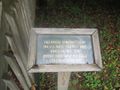 Builders of the bridge
 -
 Trail Profile
 -
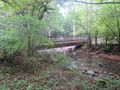 Bridge over Doe River
 -
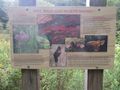 Boardwalk sign

