Shelter:Cherry Gap: Difference between revisions
Jump to navigation
Jump to search
(Added infobox) |
(→Maintenance History: Added May 1999 entry) |
||
| (5 intermediate revisions by 2 users not shown) | |||
| Line 2: | Line 2: | ||
{{Infobox Shelter | {{Infobox Shelter | ||
| Image Name = Cherry Gap Shelter.jpg | | Image Name = Cherry Gap Shelter.jpg | ||
| Shelter = Cherry Gap | |||
| Capacity = 6 | | Capacity = 6 | ||
| Privy = No | | Privy = No | ||
| DistanceN = 2.7 | |||
| DistanceS = 7.0 | |||
| Elevation = 3,900 | | Elevation = 3,900 | ||
| Latitude = 36.12915 | | Latitude = 36.12915 | ||
| Longitude = -82.26427 | | Longitude = -82.26427 | ||
| Medical = Erwin, TN | | Medical = Erwin, TN | ||
}} | }} | ||
<!-- End Infobox template table--> | <!-- End Infobox template table--> | ||
| Line 24: | Line 22: | ||
== Location == | == Location == | ||
<!-- describe general location info --> | <!-- describe general location info --> | ||
Trail-north of Unaka Mountain between Iron Mountain Gap and Nolichucky River. | Trail-north of Unaka Mountain between [[Indian Grave Gap to Iron Mountain Gap|Iron Mountain Gap and Nolichucky River]]. | ||
== Water == | == Water == | ||
| Line 32: | Line 30: | ||
== Maintenance History == | == Maintenance History == | ||
<!-- describe history of the shelter --> | <!-- describe history of the shelter --> | ||
*Dec 1999: Dug out spring to greatly improving water flow. | |||
*May 1999: New table carried in and installed. | |||
*Oct 1993: Installed new supports, rafters, and painted metal roof. | *Oct 1993: Installed new supports, rafters, and painted metal roof. | ||
*1962: Built by U.S. Forest Service. | *1962: Built by U.S. Forest Service. | ||
Latest revision as of 20:05, 25 September 2014

| ||
| Shelter | Cherry Gap | |
| Capacity | 6 People | |
| Privy | No | |
| Trail Head Distance N | 2.7 Miles | |
| Trail Head Distance S | 7.0 Miles | |
| Elevation | 3,900 Feet | |
| Latitude | {{#lat_deg2dms: 36.12915}} | |
| Longitude | {{#long_deg2dms: -82.26427}} | |
| Nearest Medical | Erwin, TN | |
|
|
||
| Show Large Map | ||
Description[edit]
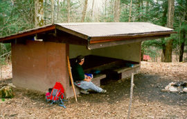
Three-sided concrete-block shelter with open front and wooden sleeping platform.
Location[edit]
Trail-north of Unaka Mountain between Iron Mountain Gap and Nolichucky River.
Water[edit]
Spring is 250 feet southwest of shelter on blue-blazed side trail.
Maintenance History[edit]
- Dec 1999: Dug out spring to greatly improving water flow.
- May 1999: New table carried in and installed.
- Oct 1993: Installed new supports, rafters, and painted metal roof.
- 1962: Built by U.S. Forest Service.
Photo Gallery[edit]
| Shelter name | Section | Trail distance from Damascus |
|---|---|---|
| Abingdon Gap Shelter | US421 to Damascus | 10.2 |
| McQueens Knob Shelter (emergency shelter) | US421 to Damascus | 11.7 |
| Double Springs Shelter | TN91 to US421 | 18.5 |
| Iron Mountain Shelter | Wilbur Dam Rd to TN91 | 26.2 |
| Vandeventer Shelter | Wilbur Dam Rd to TN91 | 33.0 |
| Laurel Fork Shelter | Dennis Cove Rd to Wilbur Dam Rd | 49.5 |
| Moreland Gap Shelter | US19E to Dennis Cove Rd | 57.0 |
| Mountaineer Falls Shelter | US19E to Dennis Cove Rd | 66.6 |
| Stan Murray Shelter | Carver's Gap to US19E | 86.5 |
| Roan High Knob Shelter | Iron Mountain Gap to Carver's Gap | 91.7 |
| Clyde Smith Shelter | Iron Mountain Gap to Carver's Gap | 100.2 |
| Cherry Gap Shelter | Indian Grave Gap to Iron Mountain Gap | 109.3 |
| Curley Maple Gap Shelter | Nolichucky River to Indian Grave Gap | 122.2 |
| No Business Knob Shelter | Spivey Gap to Nolichucky River | 132.7 |
Per the 2021 AT Data Book.
