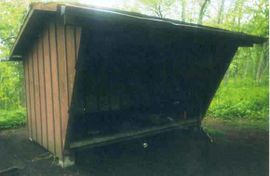
Shelter:Stan Murray: Difference between revisions
Jump to navigation
Jump to search
(→Maintenance History: More from old website) |
(→Maintenance History: Nov 2017 added) |
||
| (10 intermediate revisions by 2 users not shown) | |||
| Line 1: | Line 1: | ||
<!-- The following few lines create the "Infobox" table template. Please scroll down to edit the main content of the article. --> | |||
{{Infobox Shelter | |||
| Image Name = Stan Murray Shelter.jpg | |||
| Shelter = Stan Murray | |||
| Capacity = 6 | |||
| Privy = No | |||
| DistanceN = 10.4 | |||
| DistanceS = 3.3 | |||
| Elevation = 5,050 | |||
| Latitude = 36.112362 | |||
| Longitude = -82.065734 | |||
| Medical = Elizabethton, TN | |||
}} | |||
<!-- End Infobox template table--> | |||
<!-- Start of Main Page --> | |||
== Description == | == Description == | ||
<!-- describe basic features, attraction, etc... --> | <!-- describe basic features, attraction, etc... --> | ||
| Line 5: | Line 21: | ||
== Location == | == Location == | ||
<!-- describe general location info --> | <!-- describe general location info --> | ||
On the north slope of Grassy Ridge in Low Gap, 3.3 miles from [[Carver's Gap to US19E|Carver's Gap towards US19E]]. | |||
== Water == | == Water == | ||
| Line 13: | Line 29: | ||
== Maintenance History == | == Maintenance History == | ||
<!-- describe history of the shelter --> | <!-- describe history of the shelter --> | ||
*Nov 2017: Installed graffiti board | |||
*Oct 2017: Major rehab event - raised back of shelter to level sleeping platform, made new sleeping platform, sealed under platform to reduce trash, repaired rafters, installed metal roof, replaced some battens, painted both inside and outside, and stiffened picnic table. | |||
*Oct 2000: Inside painted to cover up graffiti. | *Oct 2000: Inside painted to cover up graffiti. | ||
*1995: Renamed from Roan Highlands Shelter to Stan Murray Shelter. | *1995: Renamed from Roan Highlands Shelter to Stan Murray Shelter. | ||
*1994: Installed picnic table, painted shelter. | *1994: Installed picnic table, painted shelter. | ||
*1993: Extended roof and sides, added gutters front and rear, repaired hole in floor, reinforced floor in front. | *1993: Extended roof and sides, added gutters front and rear, repaired hole in floor, reinforced floor in front. | ||
*1977: Built by the United States Forest Service. | |||
== Photo Gallery == | == Photo Gallery == | ||
<gallery> | <gallery> | ||
<!-- Place any pictures from this trail below. Add a picture by typing Image:imagename.extension --> | <!-- Place any pictures from this trail below. Add a picture by typing Image:imagename.extension --> | ||
Image: | Image:Stan Murray Shelter.jpg | ||
</gallery> | </gallery> | ||
<!-- Do not remove the end gallery code.--> | <!-- Do not remove the end gallery code.--> | ||
{{Template:TEHCC Shelters}} | {{Template:TEHCC Shelters}} | ||
Latest revision as of 11:04, 21 December 2018

| ||
| Shelter | Stan Murray | |
| Capacity | 6 People | |
| Privy | No | |
| Trail Head Distance N | 10.4 Miles | |
| Trail Head Distance S | 3.3 Miles | |
| Elevation | 5,050 Feet | |
| Latitude | {{#lat_deg2dms: 36.112362}} | |
| Longitude | {{#long_deg2dms: -82.065734}} | |
| Nearest Medical | Elizabethton, TN | |
|
|
||
| Show Large Map | ||
Description[edit]
A wood plank structure. Previously known as the Roan Highlands Shelter, it was renamed to honor Stan Murray - long time TEHCC leader, ATC board member and founder of the Southern Appalachian Highlands Conservancy.
Location[edit]
On the north slope of Grassy Ridge in Low Gap, 3.3 miles from Carver's Gap towards US19E.
Water[edit]
Water is found 100 yards from the shelter on a blue blaze trail.
Maintenance History[edit]
- Nov 2017: Installed graffiti board
- Oct 2017: Major rehab event - raised back of shelter to level sleeping platform, made new sleeping platform, sealed under platform to reduce trash, repaired rafters, installed metal roof, replaced some battens, painted both inside and outside, and stiffened picnic table.
- Oct 2000: Inside painted to cover up graffiti.
- 1995: Renamed from Roan Highlands Shelter to Stan Murray Shelter.
- 1994: Installed picnic table, painted shelter.
- 1993: Extended roof and sides, added gutters front and rear, repaired hole in floor, reinforced floor in front.
- 1977: Built by the United States Forest Service.
Photo Gallery[edit]
| Shelter name | Section | Trail distance from Damascus |
|---|---|---|
| Abingdon Gap Shelter | US421 to Damascus | 10.2 |
| McQueens Knob Shelter (emergency shelter) | US421 to Damascus | 11.7 |
| Double Springs Shelter | TN91 to US421 | 18.5 |
| Iron Mountain Shelter | Wilbur Dam Rd to TN91 | 26.2 |
| Vandeventer Shelter | Wilbur Dam Rd to TN91 | 33.0 |
| Laurel Fork Shelter | Dennis Cove Rd to Wilbur Dam Rd | 49.5 |
| Moreland Gap Shelter | US19E to Dennis Cove Rd | 57.0 |
| Mountaineer Falls Shelter | US19E to Dennis Cove Rd | 66.6 |
| Stan Murray Shelter | Carver's Gap to US19E | 86.5 |
| Roan High Knob Shelter | Iron Mountain Gap to Carver's Gap | 91.7 |
| Clyde Smith Shelter | Iron Mountain Gap to Carver's Gap | 100.2 |
| Cherry Gap Shelter | Indian Grave Gap to Iron Mountain Gap | 109.3 |
| Curley Maple Gap Shelter | Nolichucky River to Indian Grave Gap | 122.2 |
| No Business Knob Shelter | Spivey Gap to Nolichucky River | 132.7 |
Per the 2021 AT Data Book.
