The Channels Natural Area Preserve
| The Channels Natural Area Preserve | |
|---|---|

| |
| Park Type | State Natural Area |
| Located | Rosedale, Virginia |
| External Links | Official Website |
| Entrance Fee | Unknown |
| ActivitiesThings to do at the park | |
| Park AmenitiesThings built to enjoy or use at the park | |
| FeaturesNatural things to see at the park | |
| Park Trails |
2 Trails / Total of 8.36 miles13.454 km <br /> |
| Lodging Types | None |
| Park Area | 721 acres2.918 km² <br /> |
| Operated By | Virginia Department of Forestry |
| Main Location | 36° 51' 53.03" N, 81° 56' 49.20" W Map |
|
| |
| Show In Google Maps | |
Limited Parking Space |
|---|
| Notice: Beginning June 10, 2020, the parking area at Channels Natural Area Preserve is limited to 10 vehicles. If the parking area is full when you arrive, please come back another time. Parking along Highway 80 is not permitted, and violators will be ticketed. Visit the park website for details |
Download KML / Upload new version / KML File Page
Park Overview
The Channels, the 53rd state natural area preserve, is an area of significant high elevation forest, rock outcrop and cliff communities. The preserve name is derived from the maze-like system of sandstone crevices and boulders that occur near the 4208ft. summit of Middle Knob on Clinch mountain.
The preserve itself is located within The Channels State Forest and the trails assigned to it exist well outside of the preserve, and partially outside of the forest.
Note!: When people say they are going to The Channels, they are likely referring to hiking on the Brumley Mountain Trail (whether they know it or not). Starting from the east end along VA-80 hiking west to reach The Channels in under three miles. See the Park Trails section and the Brumley Mountain Trail page for more details.
How To Get There
Park Trails
The Channels Natural Area Preserve has the following 2 trails totaling 8.36 miles.
| Park Trails | Distance | Difficulty | Marking | Usage | Highlight |
|---|---|---|---|---|---|
| Brumley Mountain Trail | 2.96 mi | Medium | White diamond |
|
Your likely trail if you want to "go to The Channels" |
| Channels Trail | 5.40 mi | Hard | Red blaze |
|
Although your likely goal, not the typical access |
Despite overwhelmingly used as the 3mi access to The Channels, the Brumley Mountain Trail is actually a 14.6 mile trail from a parking spot on Rt 690 to parking spot on VA-80.
An actual trail called Channels Trail does exist. During off-season, it is 5.5 miles starting from a parking spot on Rt. 689/Brumley Gap Road. Otherwise, a steeper (~2X) 3.2 mile climb from parking reached by a gravel forest road. This route intersects Brumley Mountain Trail to the west of the spur trail to The Channels.
Fees, Permits, etc.
Park Lodging
Inn
Cabins
Campground
Other Park Amenities
Seasonal Events
Miscellaneous Information
Gallery
-
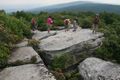
Hikers above the Channels - NOTE! No longer permitted