Loading map...
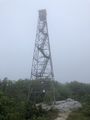
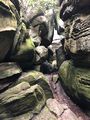
{"format":"googlemaps3","type":"TERRAIN","minzoom":false,"maxzoom":false,"types":["SATELLITE","HYBRID","TERRAIN"],"limit":50,"offset":0,"link":"none","sort":[""],"order":[],"headers":"show","mainlabel":"","intro":"","outro":"","searchlabel":"... further results","default":"","import-annotation":false,"width":"auto","height":"600px","centre":false,"title":"","label":"","icon":"","lines":[],"polygons":[],"circles":[],"rectangles":[],"copycoords":false,"static":false,"visitedicon":"","wmsoverlay":false,"zoom":false,"layers":[],"controls":["pan","zoom","type","scale","streetview","rotate"],"zoomstyle":"DEFAULT","typestyle":"DEFAULT","autoinfowindows":false,"resizable":false,"kmlrezoom":true,"poi":true,"cluster":false,"clustergridsize":60,"clustermaxzoom":20,"clusterzoomonclick":true,"clusteraveragecenter":true,"clusterminsize":2,"imageoverlays":[],"kml":[],"gkml":["https://tehcc.org/clubwiki/images/Brumley_Mountain_Trail.kml","https://tehcc.org/clubwiki/images/Channels_Trail.kml"],"searchmarkers":"","fullscreen":false,"scrollwheelzoom":false,"showtitle":false,"hidenamespace":true,"template":"Map Balloon Template","userparam":"","activeicon":"","pagelabel":false,"ajaxcoordproperty":"","ajaxquery":"","locations":[{"text":"\u003Cp\u003E\u003Cb\u003E\u003Ca href=\"/wiki/Brumley_Mountain_Trail\" title=\"Brumley Mountain Trail\"\u003EBrumley Mountain Trail\u003C/a\u003E\u003C/b\u003E\u003Cbr /\u003E\u003C/p\u003E\u003Chr /\u003E\u003Cp\u003E2.96\u0026#160;Mi (4.76\u0026#160;km)\u003Cbr /\u003EDifficulty: Medium\u003Cbr /\u003EMarking: White diamond\u003C/p\u003E","title":"Brumley Mountain Trail","link":"","lat":36.8639500000000026602720026858150959014892578125,"lon":-81.9472899999999953024598653428256511688232421875,"icon":"/clubwiki/images/MarkerT.png"},{"text":"\u003Cp\u003E\u003Cb\u003ESplit with Brumley Mountain Trail\u003C/b\u003E\u003Cbr /\u003E\u003C/p\u003E\u003Chr /\u003E\u003Cp\u003ESplit with Brumley Mountain Trail\u003C/p\u003E","title":"Brumley Mountain Trail","link":"","lat":36.87195700000000186946635949425399303436279296875,"lon":-81.978305000000005975380190648138523101806640625,"icon":"/clubwiki/images/MarkerT.png"},{"text":"\u003Cp\u003E\u003Cb\u003EThe Channels\u003C/b\u003E\u003Cbr /\u003E\u003C/p\u003E\u003Chr /\u003E\u003Cp\u003EThe Channels\u003C/p\u003E","title":"Brumley Mountain Trail","link":"","lat":36.87093399999999832061803317628800868988037109375,"lon":-81.9798250000000052750692702829837799072265625,"icon":"/clubwiki/images/MarkerG.png"},{"text":"\u003Cp\u003E\u003Cb\u003EOld cabin for fire watch\u003C/b\u003E\u003Cbr /\u003E\u003C/p\u003E\u003Chr /\u003E\u003Cp\u003EOld cabin for fire watch\u003C/p\u003E","title":"Brumley Mountain Trail","link":"","lat":36.871229999999997062332113273441791534423828125,"lon":-81.978149999999999408828443847596645355224609375,"icon":"/clubwiki/images/MarkerV.png"},{"text":"\u003Cp\u003E\u003Cb\u003ETurn off road (stay straight while road switchbacks right)\u003C/b\u003E\u003Cbr /\u003E\u003C/p\u003E\u003Chr /\u003E\u003Cp\u003ETurn off road (stay straight while road switchbacks right)\u003C/p\u003E","title":"Brumley Mountain Trail","link":"","lat":36.86116100000000272984834737144410610198974609375,"lon":-81.955637999999993326127878390252590179443359375,"icon":"/clubwiki/images/MarkerG.png"},{"text":"\u003Cp\u003E\u003Cb\u003EHayters Gap Road Trailhead\u003C/b\u003E\u003Cbr /\u003E\u003C/p\u003E\u003Chr /\u003E\u003Cp\u003EHayters Gap Road Trailhead\u003C/p\u003E","title":"Brumley Mountain Trail","link":"","lat":36.864609999999998990460881032049655914306640625,"lon":-81.9470299999999980400389176793396472930908203125,"icon":"/clubwiki/images/MarkerA.png"},{"text":"\u003Cp\u003E\u003Cb\u003EBrumley Gap Trailhead\u003C/b\u003E\u003Cbr /\u003E\u003C/p\u003E\u003Chr /\u003E\u003Cp\u003EBrumley Gap Trailhead\u003C/p\u003E","title":"Brumley Mountain Trail","link":"","lat":36.82803299999999779856807435862720012664794921875,"lon":-81.9621329999999943538568913936614990234375,"icon":"/clubwiki/images/MarkerA.png"},{"text":"\u003Cp\u003E\u003Cb\u003EPrivate cabin\u003C/b\u003E\u003Cbr /\u003E\u003C/p\u003E\u003Chr /\u003E\u003Cp\u003EPrivate cabin\u003C/p\u003E","title":"Brumley Mountain Trail","link":"","lat":36.8634890000000012832970242016017436981201171875,"lon":-81.959281000000004269168130122125148773193359375,"icon":"/clubwiki/images/MarkerV.png"},{"text":"\u003Cp\u003E\u003Cb\u003EOverlook at fire tower\u003C/b\u003E\u003Cbr /\u003E\u003C/p\u003E\u003Chr /\u003E\u003Cp\u003EOverlook at fire tower\u003C/p\u003E","title":"Brumley Mountain Trail","link":"","lat":36.87142399999999753390511614270508289337158203125,"lon":-81.978036000000003014065441675484180450439453125,"icon":"/clubwiki/images/MarkerE.png"},{"text":"\u003Cp\u003E\u003Cb\u003EOverlook to Tri-Cities\u003C/b\u003E\u003Cbr /\u003E\u003C/p\u003E\u003Chr /\u003E\u003Cp\u003EOverlook to Tri-Cities\u003C/p\u003E","title":"Brumley Mountain Trail","link":"","lat":36.8710549999999983583620632998645305633544921875,"lon":-81.977652000000006182744982652366161346435546875,"icon":"/clubwiki/images/MarkerE.png"},{"text":"\u003Cp\u003E\u003Cb\u003EFire tower\u003C/b\u003E\u003Cbr /\u003E\u003C/p\u003E\u003Chr /\u003E\u003Cp\u003EFire tower\u003C/p\u003E","title":"Brumley Mountain Trail","link":"","lat":36.87133800000000150021151057444512844085693359375,"lon":-81.9785509999999959518390824086964130401611328125,"icon":"/clubwiki/images/Marker2.png"},{"text":"\u003Cp\u003E\u003Cb\u003EPower line crossing\u003C/b\u003E\u003Cbr /\u003E\u003C/p\u003E\u003Chr /\u003E\u003Cp\u003EPower line crossing\u003C/p\u003E","title":"Brumley Mountain Trail","link":"","lat":36.86142300000000204818206839263439178466796875,"lon":-81.9532769999999999299689079634845256805419921875,"icon":"/clubwiki/images/Powerline.png"},{"text":"\u003Cp\u003E\u003Cb\u003E\u003Ca class=\"mw-selflink selflink\"\u003EChannels Trail\u003C/a\u003E\u003C/b\u003E\u003Cbr /\u003E\u003C/p\u003E\u003Chr /\u003E\u003Cp\u003E5.40\u0026#160;Mi (8.69\u0026#160;km)\u003Cbr /\u003EDifficulty: Hard\u003Cbr /\u003EMarking: Red blaze\u003C/p\u003E","title":"Channels Trail","link":"","lat":36.82865000000000321733750752173364162445068359375,"lon":-81.9628900000000015779733075760304927825927734375,"icon":"/clubwiki/images/MarkerT.png"},{"text":"\u003Cp\u003E\u003Cb\u003EThe Channels\u003C/b\u003E\u003Cbr /\u003E\u003C/p\u003E\u003Chr /\u003E\u003Cp\u003EOverlook sign\u003C/p\u003E","title":"Channels Trail","link":"","lat":36.87119333333299664445803500711917877197265625,"lon":-81.9792416666669936375910765491425991058349609375,"icon":"/clubwiki/images/MarkerB.png"},{"text":"\u003Cp\u003E\u003Cb\u003EHayter firetower\u003C/b\u003E\u003Cbr /\u003E\u003C/p\u003E\u003Chr /\u003E\u003Cp\u003EDo Not Climb!\u003C/p\u003E","title":"Channels Trail","link":"","lat":36.87120166666699816460095462389290332794189453125,"lon":-81.9785616666670051699838950298726558685302734375,"icon":"/clubwiki/images/Marker2.png"},{"text":"\u003Cp\u003E\u003Cb\u003EBrumley Mtn Trail\u003C/b\u003E\u003Cbr /\u003E\u003C/p\u003E\u003Chr /\u003E\u003Cp\u003E10.5 mi sign\u003C/p\u003E","title":"Channels Trail","link":"","lat":36.87601000000000084355633589439094066619873046875,"lon":-81.9790183333330020332141430117189884185791015625,"icon":"/clubwiki/images/MarkerG.png"},{"text":"\u003Cp\u003E\u003Cb\u003ELot for full trail length\u003C/b\u003E\u003Cbr /\u003E\u003C/p\u003E\u003Chr /\u003E\u003Cp\u003EIf seasonal gate is closed\u003C/p\u003E","title":"Channels Trail","link":"","lat":36.82880666666699909228555043227970600128173828125,"lon":-81.962478333332995816817856393754482269287109375,"icon":"/clubwiki/images/MarkerA.png"},{"text":"\u003Cp\u003E\u003Cb\u003EChannels NAP\u003C/b\u003E\u003Cbr /\u003E\u003C/p\u003E\u003Chr /\u003E\u003Cp\u003EBoundary sign\u003C/p\u003E","title":"Channels Trail","link":"","lat":36.86709333333300264712306670844554901123046875,"lon":-81.986273333333002710787695832550525665283203125,"icon":"/clubwiki/images/MarkerT.png"},{"text":"\u003Cp\u003E\u003Cb\u003EFront Entrance\u003C/b\u003E\u003Cbr /\u003E\u003C/p\u003E\u003Chr /\u003E\u003Cp\u003EChannels State Forest sign\u003C/p\u003E","title":"Channels Trail","link":"","lat":36.82761166666700347605001297779381275177001953125,"lon":-81.9624833333329974038861109875142574310302734375,"icon":"/clubwiki/images/MarkerG.png"},{"text":"\u003Cp\u003E\u003Cb\u003ESeasonal Parking Lot\u003C/b\u003E\u003Cbr /\u003E\u003C/p\u003E\u003Chr /\u003E\u003Cp\u003EUpper of two lots\u003C/p\u003E","title":"Channels Trail","link":"","lat":36.8494400000000013051248970441520214080810546875,"lon":-81.9825183333330045343245728872716426849365234375,"icon":"/clubwiki/images/MarkerA.png"},{"text":"\u003Cp\u003E\u003Cb\u003EForest gate\u003C/b\u003E\u003Cbr /\u003E\u003C/p\u003E\u003Chr /\u003E\u003Cp\u003ESeasonally open\u003C/p\u003E","title":"Channels Trail","link":"","lat":36.82884500000000116415321826934814453125,"lon":-81.963558333332997563047683797776699066162109375,"icon":"/clubwiki/images/MarkerG.png"},{"text":"\u003Cp\u003E\u003Cb\u003ELogging work area\u003C/b\u003E\u003Cbr /\u003E\u003C/p\u003E\u003Chr /\u003E\u003Cp\u003EPick right direction\u003C/p\u003E","title":"Channels Trail","link":"","lat":36.8547549999999972669684211723506450653076171875,"lon":-81.988421666666994269689894281327724456787109375,"icon":"/clubwiki/images/MarkerG.png"},{"text":"\u003Cp\u003E\u003Cb\u003EKiosk\u003C/b\u003E\u003Cbr /\u003E\u003C/p\u003E\u003Chr /\u003E\u003Cp\u003EForest information\u003C/p\u003E","title":"Channels Trail","link":"","lat":36.82864666666699804409290663897991180419921875,"lon":-81.9628916666670050972243188880383968353271484375,"icon":"/clubwiki/images/MarkerT.png"},{"text":"\u003Cp\u003E\u003Cb\u003ESpur trail to Channels\u003C/b\u003E\u003Cbr /\u003E\u003C/p\u003E\u003Chr /\u003E\u003Cp\u003ESpur trail to Channels\u003C/p\u003E","title":"Channels Trail","link":"","lat":36.8735383333330020150242489762604236602783203125,"lon":-81.9790566666670059703392325900495052337646484375,"icon":"/clubwiki/images/MarkerT.png"},{"text":"\u003Cp\u003E\u003Cb\u003ESeasonal Parking Lot\u003C/b\u003E\u003Cbr /\u003E\u003C/p\u003E\u003Chr /\u003E\u003Cp\u003ELower of two lots\u003C/p\u003E","title":"Channels Trail","link":"","lat":36.8339766666669987671411945484578609466552734375,"lon":-81.9683383333329942388445488177239894866943359375,"icon":"/clubwiki/images/MarkerA.png"},{"text":"\u003Cp\u003E\u003Cb\u003EWhiterock Branch\u003C/b\u003E\u003Cbr /\u003E\u003C/p\u003E\u003Chr /\u003E\u003Cp\u003EEasy stream crossing\u003C/p\u003E","title":"Channels Trail","link":"","lat":36.86767499999999841975295566953718662261962890625,"lon":-81.986279999999993606252246536314487457275390625,"icon":"/clubwiki/images/MarkerJ.png"},{"text":"\u003Cp\u003E\u003Cb\u003EBrumley Mtn Trail\u003C/b\u003E\u003Cbr /\u003E\u003C/p\u003E\u003Chr /\u003E\u003Cp\u003ETrail intersection\u003C/p\u003E","title":"Channels Trail","link":"","lat":36.87668000000000034788172342814505100250244140625,"lon":-81.98032499999999345163814723491668701171875,"icon":"/clubwiki/images/MarkerG.png"}]}
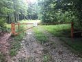
This location is open all year for the entire 5.5 mile trail distance to The Channels. A gate is locked just past this point during the off-season. If the latter is open, then high-clearance vehicles with four-wheel drive could proceed up a couple of miles to an upper parking area to shorten the hike and climb. While the forest road is in great condition, low-clearance sedans would bottom out in the frequent water diversions.
An in-and-out hike. This description starts from the bottom, but seasonal access allows shorter round trip from upper parking lot.
Lower section is gravel forest road. Growth on both sides was likely mown in 2019. Past the upper logging workspace, the trail continues on unmaintained forest roads - mostly as a single track. Weeds, primarily stinging nettle, can be tall in places. Patches of red-flowering Indian Paintbrush also seen. All runoff crossings were easy to make - even after a hard rain the prior night.
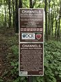
The dark red blazes were refreshed twice in 2021. There are two places you need to make correct choices. First, at the logging workspace, the trail continues down an unmaintained forest road - roughly 10 o'clock from where you entered. Additional blaze was added near the intersection then they continue several hundred feet down the trail. Second, at the tee-intersection with Brumley Mountain Trail with many Posted - No Trespassing signs, the desired route is to the right.
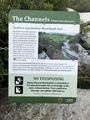
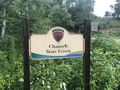
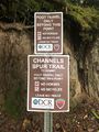
The Channels State Forest is open from dawn to dusk. No fee to park and walk the trail. No camping.
Head to Abingdon for an outdoor lunch in one of the many restaurants.
Managed by Virginia Department of Forestry (106 Forestry Lane / Galax, Virginia 24333). Phone: (276) 236-2322