Wilbur Dam Rd to TN91

| ||
| Section | 5-6-7 | |
| Trail south point | Wilbur Dam Rd | |
| Trail north point | TN91 | |
| Distance | 16.1 Miles | |
| Min Elevation | 1,958 Feet | |
| Max Elevation | 3,742 Feet | |
| Governing Body | Watauga | |
|
|
||
| Show Large Map | ||
(Trail South > North)
Wilbur Dam Road
This is the last access point to the Trail before the long ridge walk along Iron Mountain. It can be reached from Stoney Creek via TN91 or from Elizabethton via Siam. The road is gated during the winter approximately 2 miles from the Trail.
Vandeventer Shelter
Vandeventer Shelter (3510') is a concrete block shelter built by the United States Forest Service in 1961. It is located within the Big Laurel Branch Wilderness. Nearby are tremendous views of Watauga Lake.
Iron Mountain Shelter
Iron Mountain Shelter (4125') is a concrete block shelter built the United States Forest Service in 1960.
Uncle Nick Grindstaff Monument
This monument is the gravesite of hermit Nick Grindstaff (b. Dec 26, 1851, d. July 22, 1923). He lived a remote existence on Iron Mountain after being robbed and beaten out west. The chimney-like monument was constructed out of the remains of his cabin. Local folklore tell that when locals tried to carry out the body of Nick, his dog was so protective that they had to overpower it. It was later laid to rest with Nick. Past hikers who have camped at the site have claimed to hear the haunting howls of the dog in the night.
Iron Mountain Trail
The Iron Mountain Trail does not intersect with the AT, but can be reached by continuing east on Cross Mountain Road from the TN91 trailhead. The IMT runs along the eastern rim of Shady Valley into Damascus.
TN91
Located at the ridge crest of Cross Mountain between Stoney Creek and Shady Valley at Osborne Farm. There are two parking areas at the highway - space for three vehicles on north side and 10-12 on the south by the Cherokee National Forest information display.
Recent Conditions
1/21/2014 - Reports are in of repeated vandalism at the Cross Mountain trailhead. Either do not leave vehicles here for extended periods of time or hide/lockup/take with you any valuables from your vehicle.
Maps
Photos
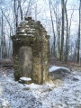
Uncle Nick Grindstaff monument