White Rock Trail: Difference between revisions
(Update IB to new format) |
(tweak with form) |
||
| (3 intermediate revisions by the same user not shown) | |||
| Line 1: | Line 1: | ||
{{Trail | |||
{{ | |Banner Image=File:White Rock Trail overlook.JPG | ||
|Park=Buffalo Mountain Park | |||
|Land Owner=Johnson City Parks & Rec | |||
|Trail Marking=White | |||
|Trail Use=Hiking | |||
|Trail Features=Vistas | |||
|Difficulty Rating=Medium | |||
|Hike Time=1.5 hrs | |||
|Trail Distance=1.79 mi | |||
|Round Trip Distance=3.58 mi | |||
|Trail Type=Segment | |||
|High Point=3,245 ft | |||
|Low Point=2,184 ft | |||
|Elevation Gain=1,054 ft | |||
|Elevation Loss=0 ft | |||
|Elevation Change Direction=North-to-South | |||
|Parking location=36.27865, -82.3461 | |||
|Trailhead location=36.27865, -82.3461 | |||
}} | }} | ||
{{Trail Map|Other Trails=Tower Ridge Trail}} | |||
White Rock Trail is the black line, while [[Tower Ridge Trail]] is in blue line. | |||
< | <br>Note: The route for Highridge Road is incorrect as the service road is closed with a gate. | ||
__TOC__ | |||
== Trail Overview == | == Trail Overview == | ||
Located in [[Buffalo Mountain Park]], a popular trail to the cliffs overlooking the I-26 valley. | Located in [[Buffalo Mountain Park]], a popular trail to the cliffs overlooking the I-26 valley. | ||
== How to get there == | == How to get there == | ||
Refer to the “How to get there” instructions on the [[Buffalo Mountain Park]] page. Take the gravel road left to the alternative parking area. | Refer to the “How to get there” instructions on the [[Buffalo Mountain Park]] page. Take the gravel road left to the alternative parking area. | ||
== Route Description== | == Route Description== | ||
The white-blazed White Rock Trail heads up the eastern edge of the park to the cliffs overlooking I-26 and then beyond the communication towers. Starting from the alt. parking lot, head into the forest and cross a wooden beam acting as a short bridge. At the junction with the main loop trail, turn left/east to recross the stream. A single white blaze then shows the climb up the tree roots to find a narrow trail. After 0.2 mile, a blue blazed spur trail heads over to the gravel service road. Continue heading uphill reaching the power line clearing. The blue-blazed [[Tower Ridge Trail]] heads off to the right. Proceed down a steep bank to cross the gravel service road. Follow the trail back into the forest. At an older trail sign, a red-blazed trail heads back downhill to the service road, while the main trail continues ahead north and an informal trail comes in from the right. The trail works around to the park boundary and then turns to follow the edge of the ridgeline. It descends on a rock outcropping, which is inadequately blazed from the other direction thus folks have created the previously mentioned informal spur trail by proceeding downhill. | The white-blazed White Rock Trail heads up the eastern edge of the park to the cliffs overlooking I-26 and then beyond the communication towers. Starting from the alt. parking lot, head into the forest and cross a wooden beam acting as a short bridge. At the junction with the main loop trail, turn left/east to recross the stream. A single white blaze then shows the climb up the tree roots to find a narrow trail. After 0.2 mile, a blue blazed spur trail heads over to the gravel service road. Continue heading uphill reaching the power line clearing. The blue-blazed [[Tower Ridge Trail]] heads off to the right. Proceed down a steep bank to cross the gravel service road. Follow the trail back into the forest. At an older trail sign, a red-blazed trail heads back downhill to the service road, while the main trail continues ahead north and an informal trail comes in from the right. The trail works around to the park boundary and then turns to follow the edge of the ridgeline. It descends on a rock outcropping, which is inadequately blazed from the other direction thus folks have created the previously mentioned informal spur trail by proceeding downhill. | ||
| Line 36: | Line 38: | ||
== Typical Conditions == | == Typical Conditions == | ||
While heavily used, the trail appears to have no formal maintenance. During rain, water will channel down the steep path, thus subsequently resulting in a slippery mud slide. In a couple of places, there are small springs which continually flow down the trail, thus could benefit from rock channeling or water bars. | While heavily used, the trail appears to have no formal maintenance. During rain, water will channel down the steep path, thus subsequently resulting in a slippery mud slide. In a couple of places, there are small springs which continually flow down the trail, thus could benefit from rock channeling or water bars. | ||
== | ==Fees, Permits, etc. == | ||
<!-- | <!-- Please list any Fees, Permits, Regulations, etc. that may be required on this trail.--> | ||
No fees or permits required. | |||
== Photos == | == Photos == | ||
{{Park trail gallery|Trail={{PAGENAME}}}} | |||
{{Map Marker | |||
Image:White Rock Trail - creek crossing.JPG| | |Icon Type=Parking | ||
Image:White Rock Trail - Hartsell Hollow trail sign.JPG| | |Marker Title=Alternate parking lot | ||
|Marker Location=36.278646,-82.346102 | |||
}} | |||
{{Map Marker | |||
|Icon Type=Trail bridge | |||
[[ | |Marker Title=Narrow trail bridge | ||
|Marker Location=36.277976,-82.345800 | |||
}} | |||
{{Map Marker | |||
|Icon Type=Water crossing | |||
|Marker Title=Creek crossing at Hartsell Hollow | |||
|Marker Description=[[Image:White Rock Trail - creek crossing.JPG|150px]]<br>[[Image:White Rock Trail - Hartsell Hollow trail sign.JPG|150px]] | |||
|Marker Location=36.276777,-82.346116 | |||
}} | |||
{{Map Marker | |||
|Icon Type=Road crossing | |||
|Marker Title=Junction with blue-blazed spur to service road | |||
|Marker Location=36.278021,-82.344313 | |||
}} | |||
{{Map Marker | |||
|Icon Type=Trail sign | |||
|Marker Title=Junction with blue-blazed [[Tower Ridge Trail]] | |||
|Marker Location=36.277581,-82.341454 | |||
}} | |||
{{Map Marker | |||
|Icon Type=Bench | |||
|Marker Title=Upper trailhead at bench | |||
|Marker Description=Junction with [[Fork Ridge Trail]] | |||
|Marker Location=36.266800,-82.339319 | |||
}} | |||
{{Map Marker | |||
|Icon Type=Comm tower | |||
|Marker Title=Towers | |||
|Marker Location=36.26913,-82.33833 | |||
}} | |||
{{Map Marker | |||
|Icon Type=Overlook | |||
|Marker Title=White Rock Overlook | |||
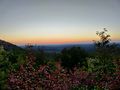
|Marker Description=[[Image:White Rock Trail overlook.JPG|150px]] | |||
|Marker Location=36.27048,-82.33703 | |||
}} | |||
Latest revision as of 22:33, 19 September 2021
| White Rock Trail (log in to submit report) | |
|---|---|

| |
| Park | Buffalo Mountain Park |
| Land Owner | Johnson City Parks & Rec |
| Located | Johnson City, TennesseeLocation inherited from associated park |
| Trail Marking | White |
| Trail UseThings allowed to do on or near the trail |
|
| FeaturesThings to see on or near the trail |
|
| Difficulty Rating | Medium |
| Hiking TimeTime from car and back. Includes any time hiking to access this trail. | 1.5 hrs0.0938 Days <br />90 Min <br /> round trip |
| Distance: | 1.79 mi2.881 km <br /> trailStrict non-repeating trail length / 3.58 mi5.761 km <br /> round tripTypical or shortest length from the car, hike the trail, and return to car |
| Trail Type | Segment |
| Low / High Point | 2,184 ft728 Yards <br />665.683 Meters <br /> / 3,245 ft1,081.667 Yards <br />989.076 Meters <br /> |
| Elev. Gain/LossSee link for details of calculation. Gain/Loss is direction dependent. | 1,054 ft321.259 Meters <br /> / (0 ft0 Meters <br />) – North-to-South |
| Trip ReportsFrom user "hiked it" submissions<br />Recent is within last 90 days | 1 logged hikes (0 recent) |
| NearbyWithin 5 mi<br />Click link to view list | 8 trails / 7.1 mi of trail |
| Parking | 36° 16' 43.14" N, 82° 20' 45.96" W Map |
| Trailhead | 36° 16' 43.14" N, 82° 20' 45.96" W Map |
|
| |
| Show In Google Maps | |
Download KML / Upload new version / KML File Page / Create Profile Chart / gpsvisualizer Map
White Rock Trail is the black line, while Tower Ridge Trail is in blue line.
Note: The route for Highridge Road is incorrect as the service road is closed with a gate.
Trail Overview[edit]
Located in Buffalo Mountain Park, a popular trail to the cliffs overlooking the I-26 valley.
How to get there[edit]
Refer to the “How to get there” instructions on the Buffalo Mountain Park page. Take the gravel road left to the alternative parking area.
Route Description[edit]
The white-blazed White Rock Trail heads up the eastern edge of the park to the cliffs overlooking I-26 and then beyond the communication towers. Starting from the alt. parking lot, head into the forest and cross a wooden beam acting as a short bridge. At the junction with the main loop trail, turn left/east to recross the stream. A single white blaze then shows the climb up the tree roots to find a narrow trail. After 0.2 mile, a blue blazed spur trail heads over to the gravel service road. Continue heading uphill reaching the power line clearing. The blue-blazed Tower Ridge Trail heads off to the right. Proceed down a steep bank to cross the gravel service road. Follow the trail back into the forest. At an older trail sign, a red-blazed trail heads back downhill to the service road, while the main trail continues ahead north and an informal trail comes in from the right. The trail works around to the park boundary and then turns to follow the edge of the ridgeline. It descends on a rock outcropping, which is inadequately blazed from the other direction thus folks have created the previously mentioned informal spur trail by proceeding downhill.
White Rock Trail continues uphill with rock outcroppings to the east for views. As it approaches the commication towers area, the trail stays in the woods to stay off the service road. Just beyond the last tower, a junction with Tower Ridge Trail is reached. The trail path appears to split into two parallel lanes continuing over to a fixed wooden bench - and junction with Fork Ridge Trail.
A roughly three mile loop hike can be done in couple of hours (plus stops) by hiking up the Tower Ridge Trail or gravel service road and returning by the White Rock Trail. The latter offers views to the east of the I-26 valley.
Typical Conditions[edit]
While heavily used, the trail appears to have no formal maintenance. During rain, water will channel down the steep path, thus subsequently resulting in a slippery mud slide. In a couple of places, there are small springs which continually flow down the trail, thus could benefit from rock channeling or water bars.
Fees, Permits, etc.[edit]
No fees or permits required.
Photos[edit]
Sunset at Huckleberry Knob
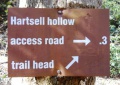
Trail sign at Hartsell Hollow
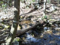
Second creek crossing
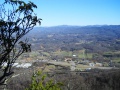
View from White Rock Trail Overlook


