White House Cliffs Trail
| |||||||||||||||||||||||||||||||||||||||||||||

Trail Overview
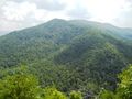
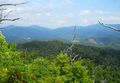
In the Rocky Fork State Park TN state park area. A steep hike to first highpoint to enjoy some views of the surrounding mountains.
How to get there
From I-26 in Tennessee at Exit 46:
- From the Exit 46 Welcome Center follow the access road back under the interstate about 0.2 miles to its end into Clear Branch Road (street sign is often missing).
- If heading east on I-26 and not wishing to stop at the Welcome Center, simply turn right off the Exit 46 ramp and follow the access road a few hundred yards down to Clear Branch Rd. (west-bound traffic will turn left from the exit ramp onto the welcome ctr. access road)
- Turn right onto Clear Branch and head down thru the tiny community of Clear Branch, past the Clear Branch Church, and down the steep grade to the stop sign - about 0.8 mile.
- Turn left onto TN-352 (old US 23 - usually no sign here either) and go about 2.5 miles to Rocky Fork Road on your right.
- Follow RF Rd. about 0.8 mile up to the parking area at the blue gate on your left. The stream along Rocky Fork Road is very scenic, with lots of cascades, deep pools and giant boulders. Great trout fishing too.
- Park in the small area on the right of the short gravel road leading to the gate. Try to leave room for other vehicles if possible.
Route Description
From the locked parking area gate, follow the gravel entrance road until pink survey tape is observed on right. The next section follows an old ungraveled logging path up the creek bed. Once out of the water path, continue following the old logging roadway around until pink survey tape is again seen on the right. Follow the flagging tape up a primative trail to a survey marker post. The last section heads right up the mountain spine to top. The best views are a bit further east from the highpoint.
| Distance (mi) | Elevation (ft) | Feature |
|---|---|---|
| 0.0 | 2,455 | Locked gate at parking lot |
| 0.5 | 2,570 | Veer right onto flagged trail |
| 1.1 | 2,970 | Sharp right from logging road onto flagged trail |
| 1.2 | 3,095 | Survey mark. Now follow spine up mountain |
| 1.4 | 3,340 | Highpoint |
Typical Conditions
This hike is a medium difficulty as the stream bed will be flowing after a rain; otherwise, potentially muddy. The trail is sparely marked with the pink survey tape and not under a regular maintenance program. Stinging nettle was commonly encountered... along with a fresh bear track. White House itself is recovering from a wildfire several years ago, thus sharp dead branches are encountered.
This trail description DOES NOT proceed out to the actual cliffs viewed from the highway as the approach is steep with loose soil, thus considered unsafe.
Fees, Permits, etc.
Not permitted on the watershed are horses, motor vehicles, fires or camping. Once off the entrance gravel road, this trail is not suitable for mountain bikes.
After the Hike
The welcome center provides restroom facilities and vending machines.
Misc. Information
Huckleberries were found on top - typically ripe in July-early August.
Maps
Photos

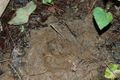
Fresh bear track!


