White House Cliffs Trail: Difference between revisions
m (add needs) |
No edit summary |
||
| Line 10: | Line 10: | ||
| Difficulty Rating = Medium | | Difficulty Rating = Medium | ||
| Hike Time = 2 Hours | | Hike Time = 2 Hours | ||
| Round Trip Distance = 2. | | Round Trip Distance = 2.00 Mi | ||
| Trail Distance = 1. | | Trail Distance = 1.00 Mi | ||
| Trail Type = In-and-Out | | Trail Type = In-and-Out | ||
| Elevation Gain = 1, | | Elevation Gain = 1,164 Ft | ||
| Elevation Loss = - | | Elevation Loss = -235 Ft | ||
| High Point = 3,330 Ft | | High Point = 3,330 Ft | ||
| Parking coords = 36. | | Parking coords = 36.0482332842, -82.5583617612 | ||
| Trailhead coords = 36. | | Trailhead coords = 36.0482332842, -82.5583617612 | ||
| Medical = Erwin, TN | | Medical = Erwin, TN | ||
}}<!-- | }}<!-- | ||
| Line 52: | Line 52: | ||
#Turn left onto TN-352 (old US 23 - usually no sign here either) and go about 2.5 miles to Rocky Fork Road on your right. | #Turn left onto TN-352 (old US 23 - usually no sign here either) and go about 2.5 miles to Rocky Fork Road on your right. | ||
#Follow RF Rd. about 0.8 mile up to the parking area at the blue gate on your left. The stream along Rocky Fork Road is very scenic, with lots of cascades, deep pools and giant boulders. Great trout fishing too. | #Follow RF Rd. about 0.8 mile up to the parking area at the blue gate on your left. The stream along Rocky Fork Road is very scenic, with lots of cascades, deep pools and giant boulders. Great trout fishing too. | ||
#Park in the | #Park in the new large gravel parking area. The Whitehouse Cliffs Trail starts by the campfire area. | ||
== Route Description== | == Route Description== | ||
<!-- Detailed description of the route. Is there any side trails that are worth traveling? --> | <!-- Detailed description of the route. Is there any side trails that are worth traveling? --> | ||
'''NEW Whitehouse Cliffs Trail'''<br> | |||
A new trail starting from the parking area was built in 2018-2019 and opened to the public on December 28th 2019. A tremendous amount of volunteer hours was put it to make the new trail.<br><br> | |||
The trail is obvious and well marked. Just follow it steeply all the way to the top. | |||
{| class="wikitable" border="1" | {| class="wikitable" border="1" | ||
| Line 66: | Line 68: | ||
|0.0 | |0.0 | ||
|2,455 | |2,455 | ||
| | |Trailhead at Campfire area | ||
|- | |- | ||
|0. | |0.6 | ||
|2, | |2,937 | ||
| | |During winter months, good close up view of cliffs themselves | ||
|- | |- | ||
|1. | |1.0 | ||
|3,340 | |3,340 | ||
|Highpoint | |Highpoint | ||
| Line 87: | Line 81: | ||
== Typical Conditions == | == Typical Conditions == | ||
<!-- Typical conditions throughout the year of what to expect on the trail. Rocky, muddy, sandy, flowers, lots of downed trees? --> | <!-- Typical conditions throughout the year of what to expect on the trail. Rocky, muddy, sandy, flowers, lots of downed trees? --> | ||
Located at the Main Parking Lot near Campfire Interpretation Area. New Whitehouse Cliffs Trail route is completely new and is the REQUIRED, marked route to reach Whitehouse Cliffs Knob overlook.<br> | |||
'''Old Whitehouse Cliffs Trailhead and Trail'''<br> | |||
Route is CLOSED TO PUBLIC (located off of Rocky Fork Trail). Staff is letting nature/forest reclaim it for Ecological Restoration. | |||
==Fees, Permits, etc. == | ==Fees, Permits, etc. == | ||
<!-- Please list any Fees, Permits, Regulations, etc. that may be required on this trail.--> | <!-- Please list any Fees, Permits, Regulations, etc. that may be required on this trail.--> | ||
Not permitted on the watershed are horses, motor vehicles, fires or camping | Not permitted on the watershed are horses, motor vehicles, fires or camping. | ||
== After the Hike == | == After the Hike == | ||
| Line 105: | Line 100: | ||
== Maps == | == Maps == | ||
<!-- You can place pictures, PDF's, links, or even create a Google map with your waypoints and place it here. --> | <!-- You can place pictures, PDF's, links, or even create a Google map with your waypoints and place it here. --> | ||
<display_map center="36.05,-82.56" type="terrain" zoom="15" width="auto" height="550" gkml="http://tehcc.org/clubwiki/kml/White_House_Cliffs_Trail.kml"> | <!-- <display_map center="36.05,-82.56" type="terrain" zoom="15" width="auto" height="550" gkml="http://tehcc.org/clubwiki/kml/White_House_Cliffs_Trail.kml"> --> | ||
<display_map center="36.05,-82.56" type="terrain" zoom="15" width="auto" height="550" gkml="http://tehcc.org/clubwiki/images/Whitehouse_Cliffs_Trail_new.kml"> | |||
36. | 36.048233,-82.558361~Trailhead to Rocky Fork Tract~Gravel Parking~MarkerT.png | ||
36. | 36.050603,-82.561469~Cliffs Viewpoint~ ~MarkerE.png | ||
36.052382,-82.560858~Highpoint~ ~MarkerE.png | 36.052382,-82.560858~Highpoint~ ~MarkerE.png | ||
</display_map> | </display_map> | ||
Revision as of 11:48, 20 January 2020
| |||||||||||||||||||||||||||||||||||||||||||||

Trail Overview
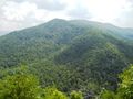
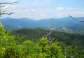
In the Rocky Fork State Park TN state park area. A steep hike to first highpoint to enjoy some views of the surrounding mountains.
How to get there
From I-26 in Tennessee at Exit 46:
- From the Exit 46 Welcome Center follow the access road back under the interstate about 0.2 miles to its end into Clear Branch Road (street sign is often missing).
- If heading east on I-26 and not wishing to stop at the Welcome Center, simply turn right off the Exit 46 ramp and follow the access road a few hundred yards down to Clear Branch Rd. (west-bound traffic will turn left from the exit ramp onto the welcome ctr. access road)
- Turn right onto Clear Branch and head down thru the tiny community of Clear Branch, past the Clear Branch Church, and down the steep grade to the stop sign - about 0.8 mile.
- Turn left onto TN-352 (old US 23 - usually no sign here either) and go about 2.5 miles to Rocky Fork Road on your right.
- Follow RF Rd. about 0.8 mile up to the parking area at the blue gate on your left. The stream along Rocky Fork Road is very scenic, with lots of cascades, deep pools and giant boulders. Great trout fishing too.
- Park in the new large gravel parking area. The Whitehouse Cliffs Trail starts by the campfire area.
Route Description
NEW Whitehouse Cliffs Trail
A new trail starting from the parking area was built in 2018-2019 and opened to the public on December 28th 2019. A tremendous amount of volunteer hours was put it to make the new trail.
The trail is obvious and well marked. Just follow it steeply all the way to the top.
| Distance (mi) | Elevation (ft) | Feature |
|---|---|---|
| 0.0 | 2,455 | Trailhead at Campfire area |
| 0.6 | 2,937 | During winter months, good close up view of cliffs themselves |
| 1.0 | 3,340 | Highpoint |
Typical Conditions
Located at the Main Parking Lot near Campfire Interpretation Area. New Whitehouse Cliffs Trail route is completely new and is the REQUIRED, marked route to reach Whitehouse Cliffs Knob overlook.
Old Whitehouse Cliffs Trailhead and Trail
Route is CLOSED TO PUBLIC (located off of Rocky Fork Trail). Staff is letting nature/forest reclaim it for Ecological Restoration.
Fees, Permits, etc.
Not permitted on the watershed are horses, motor vehicles, fires or camping.
After the Hike
The welcome center provides restroom facilities and vending machines.
Misc. Information
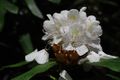
Huckleberries were found on top - typically ripe in July-early August.
Maps
Photos
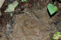
Fresh bear track!


