|
|
| (8 intermediate revisions by 3 users not shown) |
| Line 1: |
Line 1: |
| <!-- The following few lines create the "Infobox" table template. Please scroll down to edit the main content of the article. --> | | <!-- The following few lines create the "Infobox" table template. Please scroll down to edit the main content of the article. |
| {{Infobox Trail
| |
| | Image Name = PRP_Walter_Hopkins_Trail.JPG
| |
| | City = Jonesborough
| |
| | State = Tennessee
| |
| | Trail Use = {{Hike}}{{Dogs}}
| |
| | Difficulty Rating = Easy
| |
| | Hike Time = 0.5
| |
| | Distance = 0.43
| |
| | Elevation Gain = 170
| |
| | High Point = 1871
| |
| | Latitude = N36°17.1336
| |
| | Longitude = W82°30.2259
| |
| | Medical = Johnson City, TN
| |
| <!-- DON'T EDIT THE GOOGLEMAP TAG -->
| |
| | googlemap =
| |
| <googlemap lat="36.28825" lon="-82.49837" zoom="9" width="270" type="map" height="180" selector="no" controls="small">
| |
| 36.28825, -82.49837, Persimmon Ridge Park
| |
| </googlemap>
| |
| }}
| |
| <!-- End Infobox template table-->
| |
|
| |
|
| <!-- Start of Main Page --> | | -->{{Infobox Trail |
| | | Image Name = PRP_Walter_Hopkins_trail_sign.JPG |
| | | City = Jonesborough |
| | | State = Tennessee |
| | | Park = Persimmon Ridge Park |
| | | Marking = * |
| | | Trail Use = {{Hike}}{{Dogs}} |
| | | Difficulty Rating = Easy |
| | | Hike Time = 0.5 |
| | | Distance = 0.43 |
| | | Elevation Gain = 170 |
| | | High Point = 1871 |
| | | Latitude = 36.28825 |
| | | Longitude = -82.49837 |
| | | Medical = Johnson City, TN |
| | }}<!-- |
|
| |
|
| | End Infobox template table |
| | |
| | -->{{Trail page needs |
| | | Hide needs = |
| | | KML = |
| | | Updated KML = |
| | | Detail route description = Yes |
| | | Photos = |
| | | Winter photos = |
| | | Remove prefix = Yes |
| | | Update infobox = Yes |
| | | Infobox data update = Yes |
| | | Trail pins = |
| | | Other = |
| | | Comment = |
| | | Date reviewed = 10/31/2015 |
| | }}<!-- |
| | |
| | Start of Main Page --> |
| == Trail Overview == | | == Trail Overview == |
| <!-- Enter a overview of the trail. What attracts you to this trail, points of interest, types of flowers, lakes, and peaks that you see along the way. --> | | <!-- Enter a overview of the trail. What attracts you to this trail, points of interest, types of flowers, lakes, and peaks that you see along the way. --> |
| Line 33: |
Line 47: |
| == Route Description== | | == Route Description== |
| <!-- Detailed description of the route. Is there any side trails that are worth traveling? --> | | <!-- Detailed description of the route. Is there any side trails that are worth traveling? --> |
| Without a sign to definitively mark the western trailhead, used the wooden bridge as it also appears to be the start of Walter's Trail, thus the measured length of 0.7 miles is less than what was reported in the TN Greenways listing.
| | The below distance is between the trail signs. It is likely that the long wood bridge was part of Walter's Eagle project, thus should be included but was uncertain when measurements were being made. |
|
| |
|
| {| class="wikitable" border="1" | | {| class="wikitable" border="1" |
| Line 71: |
Line 85: |
| == Maps == | | == Maps == |
| <!-- You can place pictures, PDF's, links, or even create a Google map with your waypoints and place it here. --> | | <!-- You can place pictures, PDF's, links, or even create a Google map with your waypoints and place it here. --> |
| Walter Hopkins Trail is shown as green line below, while Luke Carter Trail is in red. | | Walter Hopkins Trail is shown as green line below, while Luke Carter Trail is in red. Gravel access road is blue line. |
|
| |
|
| <googlemap version="0.9" lat="36.28833" lon="-82.4986" type="terrain" zoom="15" width="700" scale="yes" icons="http://tehcc.org/clubwiki/kml/marker{label}.png"> | | <display_map center="36.288,-82.502" type="terrain" zoom="15" width="700" height="550" gkml="https://tehcc.org/clubwiki/kml/PRP_Luke_Carter_Trail.kml, |
| http://tehcc.org/clubwiki/kml/PRP_Luke_Carter_Trail.kml
| | https://tehcc.org/clubwiki/kml/PRP_Walter_Hopkins_Trail.kml, |
| http://tehcc.org/clubwiki/kml/PRP_Walter_Hopkins_Trail.kml
| | https://tehcc.org/clubwiki/kml/PRP_John_Tomko_Trail.kml, |
| http://tehcc.org/clubwiki/kml/PRP_John_Tomko_Trail.kml
| | https://tehcc.org/clubwiki/kml/PRP_Gravel_Road.kml"> |
|
| |
|
| (G) 36.285559,-82.503766
| | 36.285559,-82.503766~Northern trailhead by bench~[[Image:PRP Walter Hopkins trail sign2.JPG|150px]]~MarkerG.png |
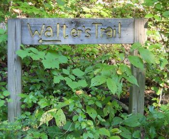
| Northern trailhead by bench | | 36.283722,-82.502489~Southern trailhead at bridge, junction with [[PRP Luke Carter Trail]]~[[Image:PRP Walter Hopkins trail sign.JPG|150px]]~MarkerG.png |
| [[Image:PRP Walter Hopkins sign1.JPG|150px]] | | 36.285986,-82.504260~Nice bench along gravel road~ ~MarkerK.png |
| (G) 36.283722,-82.502489
| | </display_map> |
| Southern trailhead at bridge, junction with [[PRP Luke Carter Trail]] | |
| [[Image:PRP Walter Hopkins sign2.JPG|150px]] | |
| </googlemap> | |
|
| |
|
| == Photos == | | == Photos == |
| Line 90: |
Line 101: |
| <!-- Place any pictures from this trail below. Ideally we would have a picture of the trailhead to help people know when they found it --> | | <!-- Place any pictures from this trail below. Ideally we would have a picture of the trailhead to help people know when they found it --> |
| <!-- Add a picture by typing Image:imagename.extension --> | | <!-- Add a picture by typing Image:imagename.extension --> |
| Image:Placeholder.gif | | Image:PRP Walter Hopkins trail sign2.JPG |
| | |
| <!-- Do not remove the end gallery code.--> | | <!-- Do not remove the end gallery code.--> |
| </gallery> | | </gallery> |
|
|
|
|
|
| Trail Name
|
Walter Hopkins Trail
|
| Park
|
Persimmon Ridge Park
|
| Nearest City
|
Jonesborough
|
| State
|
Tennessee
|
| Trail Marking
|
|
| Trail Use/Features
|
 
|
| Difficulty Rating
|
Easy
|
| Hiking Time
|
0.50.5 Hours <br />0.0313 Days <br />30 Min <br />
|
| Distance, round-trip
|
0.430.43 mi <br />0.692 km <br />
|
| Climb/Descent Elevation
|
170170 Feet <br />51.816 Meters <br /> / {{{Elevation Loss}}}"{{{Elevation Loss}}}" is not a number.
|
| High Point
|
18711,871 Feet <br />623.667 Yards <br />570.281 Meters <br />
|
| Nearest Medical
|
Johnson City, TN
|
| Trip Reports
|
Click Here
|
|
|
Loading map... {"type":"ROADMAP","minzoom":false,"maxzoom":false,"types":["ROADMAP","SATELLITE","HYBRID","TERRAIN"],"mappingservice":"googlemaps3","width":"270px","height":"180px","centre":false,"title":"","label":"","icon":"","lines":[],"polygons":[],"circles":[],"rectangles":[],"copycoords":false,"static":false,"visitedicon":"","wmsoverlay":false,"zoom":8,"layers":[],"controls":["zoom"],"zoomstyle":"DEFAULT","typestyle":"DEFAULT","autoinfowindows":false,"resizable":false,"kmlrezoom":false,"poi":true,"cluster":false,"clustergridsize":60,"clustermaxzoom":20,"clusterzoomonclick":true,"clusteraveragecenter":true,"clusterminsize":2,"imageoverlays":[],"kml":[],"gkml":[],"searchmarkers":"","fullscreen":false,"scrollwheelzoom":false,"locations":[{"text":"","title":"","link":"","lat":36.28824999999999789679350215010344982147216796875,"lon":-82.498369999999994206518749706447124481201171875,"icon":""}]} |
|
| Show Large Map
|
|
Trail Overview[edit]
Located in Persimmon Ridge Park. A short hike through second generation hardwoods which would be excellent for young families as they could combine with the other nearby trails to determine an overall length.
How to get there[edit]
Driving direction on main park page. Park at the far lot behind the water park and near the Civitans pavilion. Trail off gravel road on other side of the long wooden bridge.
Route Description[edit]
The below distance is between the trail signs. It is likely that the long wood bridge was part of Walter's Eagle project, thus should be included but was uncertain when measurements were being made.
| Miles
|
Walter Hopkins Trail
|
Miles
|
Elevation
|
| 0.0
|
Trailhead on gravel road
|
0.43
|
1711
|
| 0.16
|
Up on highpoint
|
0.27
|
1871
|
| 0.43
|
Trailhead at sign by bridge
|
0.0
|
1705
|
Typical Conditions[edit]
Hard dirt trail. Little use of switchbacks or water bars for erosion control. Might have had yellow blazes at one time, but could not see many. Someone has removed several blowdowns from the winter and spring storms, but benefited from clipping to open up the path.
Regulations[edit]
NO BIKES!
Misc. Information[edit]
The trail is named after Walter Hopkins, who led its construction for his Eagle Scout project. Might have been part of local Boy Scout Troop 39 (to be confirmed).
Walter Hopkins Trail is shown as green line below, while Luke Carter Trail is in red. Gravel access road is blue line.
Loading map...
{"type":"TERRAIN","minzoom":false,"maxzoom":false,"types":["ROADMAP","SATELLITE","HYBRID","TERRAIN"],"mappingservice":"googlemaps3","width":"700px","height":"550px","centre":{"text":"","title":"","link":"","lat":36.2879999999999967030817060731351375579833984375,"lon":-82.5019999999999953388396534137427806854248046875,"icon":""},"title":"","label":"","icon":"","lines":[],"polygons":[],"circles":[],"rectangles":[],"copycoords":false,"static":false,"visitedicon":"","wmsoverlay":false,"zoom":15,"layers":[],"controls":["pan","zoom","type","scale","streetview","rotate"],"zoomstyle":"DEFAULT","typestyle":"DEFAULT","autoinfowindows":false,"resizable":false,"kmlrezoom":false,"poi":true,"cluster":false,"clustergridsize":60,"clustermaxzoom":20,"clusterzoomonclick":true,"clusteraveragecenter":true,"clusterminsize":2,"imageoverlays":[],"kml":[],"gkml":["https://tehcc.org/clubwiki/kml/PRP_Luke_Carter_Trail.kml","https://tehcc.org/clubwiki/kml/PRP_Walter_Hopkins_Trail.kml","https://tehcc.org/clubwiki/kml/PRP_John_Tomko_Trail.kml","https://tehcc.org/clubwiki/kml/PRP_Gravel_Road.kml"],"searchmarkers":"","fullscreen":false,"scrollwheelzoom":false,"locations":[{"text":"\u003Cb\u003E\u003Cdiv class=\"mw-parser-output\"\u003E\u003Cp\u003ENorthern trailhead by bench\n\u003C/p\u003E\u003C/div\u003E\u003C/b\u003E\u003Cdiv class=\"mw-parser-output\"\u003E\u003Cp\u003E\u003Ca href=\"/wiki/File:PRP_Walter_Hopkins_trail_sign2.JPG\" class=\"image\"\u003E\u003Cimg alt=\"PRP Walter Hopkins trail sign2.JPG\" src=\"/clubwiki/images/thumb/PRP_Walter_Hopkins_trail_sign2.JPG/150px-PRP_Walter_Hopkins_trail_sign2.JPG\" decoding=\"async\" width=\"150\" height=\"130\" srcset=\"/clubwiki/images/thumb/PRP_Walter_Hopkins_trail_sign2.JPG/225px-PRP_Walter_Hopkins_trail_sign2.JPG 1.5x, /clubwiki/images/thumb/PRP_Walter_Hopkins_trail_sign2.JPG/300px-PRP_Walter_Hopkins_trail_sign2.JPG 2x\" data-file-width=\"387\" data-file-height=\"336\" /\u003E\u003C/a\u003E\n\u003C/p\u003E\u003C/div\u003E","title":"Northern trailhead by bench\n","link":"","lat":36.28555899999999923011273494921624660491943359375,"lon":-82.5037659999999988258423400111496448516845703125,"icon":"/clubwiki/images/MarkerG.png"},{"text":"\u003Cb\u003E\u003Cdiv class=\"mw-parser-output\"\u003E\u003Cp\u003ESouthern trailhead at bridge, junction with \u003Ca href=\"/wiki/PRP_Luke_Carter_Trail\" class=\"mw-redirect\" title=\"PRP Luke Carter Trail\"\u003EPRP Luke Carter Trail\u003C/a\u003E\n\u003C/p\u003E\u003C/div\u003E\u003C/b\u003E\u003Cdiv class=\"mw-parser-output\"\u003E\u003Cp\u003E\u003Ca href=\"/wiki/File:PRP_Walter_Hopkins_trail_sign.JPG\" class=\"image\"\u003E\u003Cimg alt=\"PRP Walter Hopkins trail sign.JPG\" src=\"/clubwiki/images/thumb/PRP_Walter_Hopkins_trail_sign.JPG/150px-PRP_Walter_Hopkins_trail_sign.JPG\" decoding=\"async\" width=\"150\" height=\"124\" srcset=\"/clubwiki/images/thumb/PRP_Walter_Hopkins_trail_sign.JPG/225px-PRP_Walter_Hopkins_trail_sign.JPG 1.5x, /clubwiki/images/thumb/PRP_Walter_Hopkins_trail_sign.JPG/300px-PRP_Walter_Hopkins_trail_sign.JPG 2x\" data-file-width=\"408\" data-file-height=\"336\" /\u003E\u003C/a\u003E\n\u003C/p\u003E\u003C/div\u003E","title":"Southern trailhead at bridge, junction with PRP Luke Carter Trail\n","link":"","lat":36.2837219999999973651938489638268947601318359375,"lon":-82.502488999999997076884028501808643341064453125,"icon":"/clubwiki/images/MarkerG.png"},{"text":"\u003Cdiv class=\"mw-parser-output\"\u003E\u003Cp\u003ENice bench along gravel road\n\u003C/p\u003E\u003C/div\u003E","title":"Nice bench along gravel road\n","link":"","lat":36.28598600000000118370735435746610164642333984375,"lon":-82.5042600000000021509549696929752826690673828125,"icon":"/clubwiki/images/MarkerK.png"}]}

