|
|
| (3 intermediate revisions by the same user not shown) |
| Line 1: |
Line 1: |
| <!-- The following few lines create the "Infobox" table template. Please scroll down to edit the main content of the article.
| | {{Trail |
| | |Trail System=Warriors' Path State Park Mountain Bike Trails |
| | |City=Kingsport |
| | |Land Owner=TVA Public Land |
| | |Trail Marking=None |
| | |Trail Use=Hiking, Biking, Geocaching, Fishing, Hunting |
| | |Trail Features=Vistas, Rivers |
| | |Difficulty Rating=Medium |
| | |Hike Time=1.5 hrs |
| | |Trail Distance=1.72 mi |
| | |Round Trip Distance=3.66 mi |
| | |Trail Type=Loop |
| | |High Point=1,494 Ft |
| | |Low Point=1,266 ft |
| | |Elevation Gain=204 Ft |
| | |Elevation Loss=204 Ft |
| | |Elevation Change Direction=Counter Clockwise |
| | |Parking location=36.49213, -82.46857 |
| | |Trailhead location=36.4867, -82.47498 |
| | }} |
| | {{Trail Map|Other Trails=Darwin's Revenge}} |
| | [[Darwin's Revenge]] is the red line. '''Note:''' The Shipley Ferry Rd seen near the south edge of the trail is a private road and not publicly accessible. There is no public parking and access without taking Darwin's Revenge. |
|
| |
|
| -->{{Infobox Trail
| | __TOC__ |
| | Image Name = WPSP_Mt_Bike_Trails_sign.jpg
| |
| | Park = Warriors Path State Park
| |
| | City = Kingsport
| |
| | State = Tennessee
| |
| | Marking = White
| |
| | Trail Use = {{Biking}} {{Dogs}} {{Fishing}} {{Hike}}
| |
| | Difficulty Rating = Medium
| |
| | Hike Time = 1.5 Hours
| |
| | Round Trip Distance = 3.66 Mi
| |
| | Trail Distance = 1.78 Mi
| |
| | Trail Type = Segment
| |
| | Elevation Gain = 631 Ft
| |
| | Elevation Loss = -631 Ft
| |
| | High Point = 1,522 Ft
| |
| | Parking coords = 36.492152,-82.468427
| |
| | Trailhead coords = 36.486702,-82.474977
| |
| | Medical = Indian Path Hospital
| |
| }}<!--
| |
| | |
| End Infobox template table
| |
| | |
| -->{{Trail page needs
| |
| | Hide needs = Yes
| |
| | KML =
| |
| | Updated KML =
| |
| | Detail route description =
| |
| | Photos = Yes
| |
| | Winter photos =
| |
| | Remove prefix =
| |
| | Update infobox =
| |
| | Infobox data update =
| |
| | Trail pins =
| |
| | Other =
| |
| | Comment = Looks good!
| |
| | Date reviewed = 1/2/2016
| |
| }}<!--
| |
| | |
| Start of Main Page -->
| |
| == Trail Overview == | | == Trail Overview == |
| <!-- Enter a overview of the trail. What attracts you to this trail, points of interest, types of flowers, lakes, and peaks that you see along the way. --> | | <!-- Enter a overview of the trail. What attracts you to this trail, points of interest, types of flowers, lakes, and peaks that you see along the way. --> |
| Line 59: |
Line 42: |
| == Route Description== | | == Route Description== |
| <!-- Detailed description of the route. Is there any side trails that are worth traveling? --> | | <!-- Detailed description of the route. Is there any side trails that are worth traveling? --> |
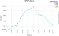
| | [[File:Wahoo-profile.png|thumb|Elevation profile]] |
| If your goal is just Wahoo, the quickest way is to begin on Lake Road until you see the sign for Darwin's Revenge to the left. This is the Darwin's Connector and is a wide path, possibly an old road that tee's up to Darwin's Revenge. Turn to the right and take the trail until you see the sign for Wahoo. | | If your goal is just Wahoo, the quickest way is to begin on Lake Road until you see the sign for Darwin's Revenge to the left. This is the Darwin's Connector and is a wide path, possibly an old road that tee's up to Darwin's Revenge. Turn to the right and take the trail until you see the sign for Wahoo. |
| | |
| | The trail itself is a relatively moderate grade up for half the trail then down. No single sections of sustained steep ascents or descent. |
|
| |
|
| {| class="wikitable" border="1" | | {| class="wikitable" border="1" |
| Line 156: |
Line 142: |
| <!-- Please list any Fees, Permits, Regulations, etc. that may be required on this trail.--> | | <!-- Please list any Fees, Permits, Regulations, etc. that may be required on this trail.--> |
| No fee required. Dogs are allowed on or off leash. Do not drink any water without treatment! | | No fee required. Dogs are allowed on or off leash. Do not drink any water without treatment! |
|
| |
| == After the Hike ==
| |
| <!-- Other things to check out while you're in the area. Restaurants, attractions, monuments, etc... -->
| |
|
| |
| == Misc. Information ==
| |
| <!-- Enter any additional information that doesn't fit an any other fields. Does this trail require any permits for overnight? parking? -->
| |
|
| |
| == Maps ==
| |
| <!-- You can place pictures, PDF's, links, or even create a Google map with your waypoints and place it here. -->
| |
| Click the official trail map:
| |
| [[File:Warriors-MTB-Trails.pdf|SORBA TriCities Trail Map]]
| |
|
| |
| [http://tnstateparks.com/assets/pdf/additional-content/warriors-path_bike-trail-map.pdf State Park Map]
| |
|
| |
| Darwin's Revenge is the red line.
| |
| <display_map center="36.487475,-82.471555" type="terrain" zoom="16" width="auto" height="550" gkml="http://tehcc.org/clubwiki/kml/WPSP_Wahoo.kml,
| |
| http://tehcc.org/clubwiki/kml/WPSP_Darwins_Revenge.kml">
| |
| 36.486702,-82.474977~Wahoo Trail Head~ ~MarkerG.png
| |
| 36.485607,-82.475936~Water Access~ ~MarkerJ.png
| |
| 36.485078,-82.476153~Lookout~View of bridges~MarkerE.png
| |
| 36.484770,-82.475452~Under I-81~ ~MarkerG.png
| |
| 36.484524,-82.474725~Resting bench~ ~MarkerK.png
| |
| 36.484605,-82.474501~Short bridge~ ~MarkerL.png
| |
| 36.483749,-82.471512~Private structure off trail right~ ~MarkerG.png
| |
| 36.487941,-82.467592~In power line cut~ ~MarkerG.png
| |
| 36.484483,-82.474199~Wahoo Split~ ~MarkerG.png
| |
| </display_map>
| |
|
| |
|
| == Photos == | | == Photos == |
| <gallery>
| | {{Park trail gallery|Trail={{PAGENAME}}}} |
| <!-- Place any pictures from this trail below. Ideally we would have a picture of the trailhead to help people know when they found it -->
| | {{Map Marker|Icon Type=Point of interest|Marker Title=Wahoo Trail Head|Marker Description= |Marker Location=36.486702,-82.474977}} |
| <!-- Add a picture by typing Image:imagename.extension -->
| | {{Map Marker|Icon Type=Water crossing|Marker Title=Water Access|Marker Description= |Marker Location=36.485607,-82.475936}} |
| | | {{Map Marker|Icon Type=Overlook|Marker Title=Lookout|Marker Description=View of bridges|Marker Location=36.485078,-82.476153}} |
| <!-- Do not remove the end gallery code.-->
| | {{Map Marker|Icon Type=Point of interest|Marker Title=Under I-81|Marker Description= |Marker Location=36.484770,-82.475452}} |
| </gallery>
| | {{Map Marker|Icon Type=Bench|Marker Title=Resting bench|Marker Description= |Marker Location=36.484524,-82.474725}} |
| | | {{Map Marker|Icon Type=Trail bridge|Marker Title=Short bridge|Marker Description= |Marker Location=36.484605,-82.474501}} |
| <!-- Finally add the trail to any Categories it should belong to. Please keep the State category. -->
| | {{Map Marker|Icon Type=Point of interest|Marker Title=Private structure off trail right|Marker Description= |Marker Location=36.483749,-82.471512}} |
| [[Category:Tennessee]] [[Category:Warriors Path State Park]] [[Category:Kingsport]] [[Category:Biking]] [[Category:Dog Friendly]]
| | {{Map Marker|Icon Type=Point of interest|Marker Title=In power line cut|Marker Description= |Marker Location=36.487941,-82.467592}} |
| | {{Map Marker|Icon Type=Point of interest|Marker Title=Wahoo Split|Marker Description= |Marker Location=36.484483,-82.474199}} |
| Wahoo
(log in to submit report)
|
|
|
|
|
| Trail System
|
Warriors' Path State Park Mountain Bike Trails
|
| Land Owner
|
TVA Public Land
|
| Located
|
Kingsport, Tennessee
|
| Trail Marking
|
None
|
| Trail UseThings allowed to do on or near the trail
|
    
|
| FeaturesThings to see on or near the trail
|
 
|
| Difficulty Rating
|
Medium
|
| Hiking TimeTime from car and back. Includes any time hiking to access this trail.
|
1.5 hrs0.0938 Days <br />90 Min <br /> round trip
|
| Distance:
|
1.72 mi2.768 km <br /> trailStrict non-repeating trail length / 3.66 mi5.89 km <br /> round tripTypical or shortest length from the car, hike the trail, and return to car
|
| Trail Type
|
Loop
|
| Low / High Point
|
1,266 ft422 Yards <br />385.877 Meters <br /> / 1,494 Ft498 Yards <br />455.371 Meters <br />
|
| Elev. Gain/LossSee link for details of calculation. Gain/Loss is direction dependent.
|
204 Ft62.179 Meters <br /> / (204 Ft62.179 Meters <br />) – Counter Clockwise
|
| Trip ReportsFrom user "hiked it" submissions<br />Recent is within last 90 days
|
1 logged hikes (0 recent)
|
| NearbyWithin 5 mi<br />Click link to view list
|
24 trails / 17.8 mi of trail
|
| Parking
|
36° 29' 31.67" N, 82° 28' 6.85" W Map
|
| Trailhead
|
36° 29' 12.12" N, 82° 28' 29.93" W Map
|
Loading map... {"type":"ROADMAP","minzoom":false,"maxzoom":false,"types":["ROADMAP","SATELLITE","HYBRID","TERRAIN"],"mappingservice":"googlemaps3","width":"100%","height":"180px","centre":false,"title":"","label":"","icon":"","lines":[],"polygons":[],"circles":[],"rectangles":[],"copycoords":false,"static":false,"visitedicon":"","wmsoverlay":false,"zoom":8,"layers":[],"controls":[""],"zoomstyle":"DEFAULT","typestyle":"DEFAULT","autoinfowindows":false,"resizable":false,"kmlrezoom":false,"poi":true,"cluster":false,"clustergridsize":60,"clustermaxzoom":20,"clusterzoomonclick":true,"clusteraveragecenter":true,"clusterminsize":2,"imageoverlays":[],"kml":[],"gkml":[],"searchmarkers":"","fullscreen":false,"scrollwheelzoom":false,"locations":[{"text":"\u003Cb\u003E\u003Cdiv class=\"mw-parser-output\"\u003E\u003Cp\u003EWahoo\n\u003C/p\u003E\u003C/div\u003E\u003C/b\u003E\u003Cdiv class=\"mw-parser-output\"\u003E\u003Cp\u003EMain Parking Location\n\u003C/p\u003E\u003C/div\u003E","title":"Wahoo\n","link":"","lat":36.492130000000003064997144974768161773681640625,"lon":-82.4685699999999997089616954326629638671875,"icon":""}]} |
| Show In Google Maps
|
Loading map...
{"format":"googlemaps3","type":"TERRAIN","minzoom":false,"maxzoom":false,"types":["SATELLITE","HYBRID","TERRAIN"],"limit":50,"offset":0,"link":"none","sort":[""],"order":[],"headers":"show","mainlabel":"","intro":"","outro":"","searchlabel":"... further results","default":"","import-annotation":false,"width":"auto","height":"600px","centre":false,"title":"","label":"","icon":"","lines":[],"polygons":[],"circles":[],"rectangles":[],"copycoords":false,"static":false,"visitedicon":"","wmsoverlay":false,"zoom":false,"layers":[],"controls":["pan","zoom","type","scale","streetview","rotate"],"zoomstyle":"DEFAULT","typestyle":"DEFAULT","autoinfowindows":false,"resizable":false,"kmlrezoom":true,"poi":true,"cluster":false,"clustergridsize":60,"clustermaxzoom":20,"clusterzoomonclick":true,"clusteraveragecenter":true,"clusterminsize":2,"imageoverlays":[],"kml":[],"gkml":["https://tehcc.org/clubwiki/images/Darwin's_Revenge.kml","https://tehcc.org/clubwiki/images/Wahoo.kml"],"searchmarkers":"","fullscreen":false,"scrollwheelzoom":false,"showtitle":false,"hidenamespace":true,"template":"Map Balloon Template","userparam":"","activeicon":"","pagelabel":false,"ajaxcoordproperty":"","ajaxquery":"","locations":[{"text":"\u003Cp\u003E\u003Cb\u003E\u003Ca href=\"/wiki/Darwin%27s_Revenge\" title=\"Darwin\u0026#39;s Revenge\"\u003EDarwin's Revenge\u003C/a\u003E\u003C/b\u003E\u003Cbr /\u003E\u003C/p\u003E\u003Chr /\u003E\u003Cp\u003E2.06\u0026#160;Mi (3.32\u0026#160;km)\u003Cbr /\u003EDifficulty: Medium\u003Cbr /\u003EMarking: Black Diamond\u003C/p\u003E","title":"Darwin's Revenge","link":"","lat":36.49085000000000178488335222937166690826416015625,"lon":-82.47025999999999612555257044732570648193359375,"icon":"/clubwiki/images/MarkerT.png"},{"text":"\u003Cp\u003E\u003Cb\u003E\u003Ca class=\"mw-selflink selflink\"\u003EWahoo\u003C/a\u003E\u003C/b\u003E\u003Cbr /\u003E\u003C/p\u003E\u003Chr /\u003E\u003Cp\u003E1.72\u0026#160;Mi (2.77\u0026#160;km)\u003Cbr /\u003EDifficulty: Medium\u003Cbr /\u003EMarking: None\u003C/p\u003E","title":"Wahoo","link":"","lat":36.4866999999999990222931955941021442413330078125,"lon":-82.4749800000000021782398107461631298065185546875,"icon":"/clubwiki/images/MarkerT.png"},{"text":"\u003Cp\u003E\u003Cb\u003EUnder I-81\u003C/b\u003E\u003Cbr /\u003E\u003C/p\u003E\u003Chr /\u003E\u003Cp\u003EUnder I-81\u003C/p\u003E","title":"Wahoo","link":"","lat":36.484769999999997480699676088988780975341796875,"lon":-82.4754520000000042045940062962472438812255859375,"icon":"/clubwiki/images/MarkerG.png"},{"text":"\u003Cp\u003E\u003Cb\u003EResting bench\u003C/b\u003E\u003Cbr /\u003E\u003C/p\u003E\u003Chr /\u003E\u003Cp\u003EResting bench\u003C/p\u003E","title":"Wahoo","link":"","lat":36.48452400000000039881342672742903232574462890625,"lon":-82.474725000000006502887117676436901092529296875,"icon":"/clubwiki/images/MarkerK.png"},{"text":"\u003Cp\u003E\u003Cb\u003EIn power line cut\u003C/b\u003E\u003Cbr /\u003E\u003C/p\u003E\u003Chr /\u003E\u003Cp\u003EIn power line cut\u003C/p\u003E","title":"Wahoo","link":"","lat":36.48794099999999929195837466977536678314208984375,"lon":-82.467591999999996232872945256531238555908203125,"icon":"/clubwiki/images/MarkerG.png"},{"text":"\u003Cp\u003E\u003Cb\u003EWahoo Split\u003C/b\u003E\u003Cbr /\u003E\u003C/p\u003E\u003Chr /\u003E\u003Cp\u003EWahoo Split\u003C/p\u003E","title":"Wahoo","link":"","lat":36.4844829999999973324520397000014781951904296875,"lon":-82.474198999999998704879544675350189208984375,"icon":"/clubwiki/images/MarkerG.png"},{"text":"\u003Cp\u003E\u003Cb\u003ELookout\u003C/b\u003E\u003Cbr /\u003E\u003C/p\u003E\u003Chr /\u003E\u003Cp\u003EView of bridges\u003C/p\u003E","title":"Wahoo","link":"","lat":36.4850780000000014524630387313663959503173828125,"lon":-82.4761529999999964957169140689074993133544921875,"icon":"/clubwiki/images/MarkerE.png"},{"text":"\u003Cp\u003E\u003Cb\u003EWahoo Trail Head\u003C/b\u003E\u003Cbr /\u003E\u003C/p\u003E\u003Chr /\u003E\u003Cp\u003EWahoo Trail Head\u003C/p\u003E","title":"Wahoo","link":"","lat":36.48670200000000107820596895180642604827880859375,"lon":-82.474976999999995541656971909105777740478515625,"icon":"/clubwiki/images/MarkerG.png"},{"text":"\u003Cp\u003E\u003Cb\u003EShort bridge\u003C/b\u003E\u003Cbr /\u003E\u003C/p\u003E\u003Chr /\u003E\u003Cp\u003EShort bridge\u003C/p\u003E","title":"Wahoo","link":"","lat":36.4846050000000019508661353029310703277587890625,"lon":-82.474501000000003614331944845616817474365234375,"icon":"/clubwiki/images/MarkerL.png"},{"text":"\u003Cp\u003E\u003Cb\u003EWater Access\u003C/b\u003E\u003Cbr /\u003E\u003C/p\u003E\u003Chr /\u003E\u003Cp\u003EWater Access\u003C/p\u003E","title":"Wahoo","link":"","lat":36.4856070000000016761987353675067424774169921875,"lon":-82.4759360000000043555701267905533313751220703125,"icon":"/clubwiki/images/MarkerJ.png"},{"text":"\u003Cp\u003E\u003Cb\u003EPrivate structure off trail right\u003C/b\u003E\u003Cbr /\u003E\u003C/p\u003E\u003Chr /\u003E\u003Cp\u003EPrivate structure off trail right\u003C/p\u003E","title":"Wahoo","link":"","lat":36.4837490000000030931914807297289371490478515625,"lon":-82.4715120000000041500243241898715496063232421875,"icon":"/clubwiki/images/MarkerG.png"}]}
Download KML / Upload new version / KML File Page / Create Profile Chart / gpsvisualizer Map
Darwin's Revenge is the red line. Note: The Shipley Ferry Rd seen near the south edge of the trail is a private road and not publicly accessible. There is no public parking and access without taking Darwin's Revenge.
Trail Overview[edit]
Although part of the Warriors Path State Park mountain bike trail system, the portion of this trail beyond I-81 is technically TVA managed public land. Most notable is that hunting is allowed on this property in accordance with state regulation.
Wahoo is only accessible from Darwin's Revenge.
How to get there[edit]
From main entrance of Warriors Path State Park:
- Go north on Fall Creek Road for 2.4 miles.
- Turn right (east) onto Old Mill Road for 0.8 miles.
- Turn right (south) onto Childress Ferry Road for just roughly 100 yards.
- Turn left (east) onto Buttermilk Road for 1.2 miles.
- Turn right (south) onto Freeman Road for 0.5 mile.
- Continue when road changes from asphalt to gravel.
Trailhead at gravel parking lot.
Route Description[edit]
If your goal is just Wahoo, the quickest way is to begin on Lake Road until you see the sign for Darwin's Revenge to the left. This is the Darwin's Connector and is a wide path, possibly an old road that tee's up to Darwin's Revenge. Turn to the right and take the trail until you see the sign for Wahoo.
The trail itself is a relatively moderate grade up for half the trail then down. No single sections of sustained steep ascents or descent.
| Miles Out
|
Wahoo
|
Miles Back
|
Elevation (ft)
|
| -0.78
|
At Parking lot
|
2.88
|
1,469
|
| -0.68
|
Connect with Darwin's Revenge
|
2.78
|
1,511
|
| -0.28
|
Split (green/black) in trail - Reroute?
|
2.38
|
1,507
|
| -0.18
|
Split reconvenes
|
2.28
|
1,423
|
| -0.11
|
Trail bridge over deep creek
|
2.21
|
1,390
|
| 0.00
|
Split to Wahoo
|
2.1
|
1,332
|
| 0.1
|
Water Access
|
2.0
|
1,273
|
| 0.17
|
Lookout to bridges
|
1.93
|
1,290
|
| 0.24
|
Under I-81
|
1.86
|
1,346
|
| 0.29
|
Bench and stream to river
|
1.81
|
1,320
|
| 0.32
|
Split for loop (continuing counterclockwise)
|
1.78
|
1,469
|
| 0.59
|
Private structure off trail right
|
1.51
|
1,420
|
| 1.0
|
In power line cut
|
1.1
|
1,497
|
| 1.78
|
Complete loop
|
0.32
|
1,469
|
| 2.1
|
Wahoo Complete
|
0.0
|
1,332
|
| 2.88
|
At Parking lot
|
-0.78
|
1,469
|
Typical Conditions[edit]
The mountain biking association SORBA Tri-Cities handles the trail maintenance, thus generally in good condition. While there are no blazes to guide you through the forest, the narrow single tracks are well established. Grab a trail map at the parking lot kiosk to help you decipher intersections; some which could use signs. Be aware for approaching bike riders who can come up quickly on your group. Step aside to let them safely pass.
Fees, Permits, etc.[edit]
No fee required. Dogs are allowed on or off leash. Do not drink any water without treatment!
