US421 to Damascus
(Trail South > North)
Low Gap - US421
Road crossing at US421. This is the closest access point to Bristol, TN/VA. Small parking area along roadside.
McQueen's Knob and McQueen's Knob Shelter
McQueen's Knob Shelter (3840') was built in 1934 and is an original AT log shelter. Today, it is no longer used as an official shelter and should only be used for emergencies. It has a dirt floor and no nearby water.
To think, I was confused a munite ago.
Backbone Rock Trail
Backbone Rock Trail is located 4.6 miles south of Damascus. It offers a 2.3 mile blue blaze trail on a narrow ridge from the AT to Backbone Rock Recreation Area which has camping and picnic facilities at a prominent rock wall which TN133 tunnels through just south of Damascus.
Begun, the great internet eduaciton has.
Oh yeah, fubalous stuff there you!
Photos
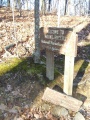
Photo of the former Mt. Rogers sign that marks the TN/VA stateline.
