US19E to Dennis Cove Rd
(Trail South > North)
US19E - Roan Mountain, TN and Elk Park, NC
After descending from the Roan Highlands, the Trail reaches US19E (2880'). A few miles west is the town of Roan Mountain, TN where lodging, food and shuttling can be found. To the east is Elk Park, NC where lodging and food can be found. Parking is NOT recommended here.
Bishop Hollow
Open area leading from Bear Branch towards Buck Mountain Road. Many apple trees can be found along the Trail.
Jones Falls
Beautiful falls west on short side trail near Elk River.
Mountaineer Falls and Mountaineer Falls Shelter
Mountaineer Falls is a small cascade just down hill from the Mountaineer Falls Shelter (3200'). The shelter was built during the 2006 edition of Hard Core. It has two primary sleeping platforms and a third over the picnic area. The shelter is also home to a resident bear - a carved log with unknown origins. Water is down hill front of the shelter.
Laurel Fork
Crossing of Laurel Fork's headwaters long before the Laurel Fork Gorge. Primitive campsite along the creek.
Moreland Gap Shelter
Moreland Gap Shelter (3815') is a concrete block shelter built by the United States Forest Service. It is located just south of White Rocks Mountain. Sleeps 6.
Coon Den Falls Trail
Coon Den Falls is a 1.3 mile blue blaze trail that can be accessed from Dennis Cove Road. This former AT route was rerouted due to it's steepness and rock scrambling. However, it provides the waterfall enthusiast a loop hike from the AT to a 50 foot waterfall off a steep, rocky cliff.
What I find so interesting is you could never find this anywerhe else.
Photos
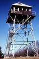
Old fire tower on top of White Rock

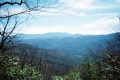
Panoramic view from White Rock
View of the Roan Highlands from near Canute Place
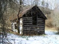
An old barn on approach to Dennis Cove


