Twin Pinnacles Trail: Difference between revisions
m (Add infobox photo) |
|||
| Line 1: | Line 1: | ||
<!-- The following few lines create the "Infobox" table template. Please scroll down to edit the main content of the article. --> | <!-- The following few lines create the "Infobox" table template. Please scroll down to edit the main content of the article. --> | ||
{{Infobox Trail | {{Infobox Trail | ||
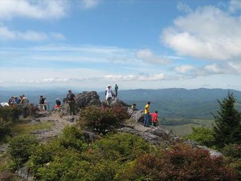
| Image Name = | | Image Name = Grayson_Highlands_SP_-_Little_Pinnacle.jpg | ||
| Trail No. = * | | Trail No. = * | ||
| City = Mouth of Wilson | | City = Mouth of Wilson | ||
Revision as of 21:35, 10 March 2011
| |||||||||||||||||||||||||||||||||||||
Trail Overview
This popular park route bags its two highest peaks of Little Pinnacle (5,089 feet) and Big Pinnacle (5,068 feet).
How to get there
Driving direction are given on the Grayson Highlands State Park page.
Trailhead is behind the visitors' center. Start at bright orange marker to begin following red blazed trail.
Alternatively, park at Massie Gap and take the 0.4 mile Big Pinnacle Trail up the mountain. Once at Twin Pinnacles Trail, head right for Big Pinnacle or left for Little Pinnacle.
Route Description
From the visitors' center, the hike begin walking through the forest until a large map sign is reached. At that point the loop can be taken either left towards Little Pnnacle or right towards Big Pinnacle. The path is through thickets of mountain laurel and rhododedron plus a favorite of many: huckleberries, which are like small blueberries (ripe in August to early September). The climb to top of Big Pinnacle is steep, but great place for lunch to look out over the valley. (Warning: Dangerous, sharp drop-off!) Part of the trail also proceeds through scrub forest with ferns.
Typical Conditions
Fees, Permits, etc.
After the Hike
Misc. Information
Maps
Photos
- Placeholder.gif
