|
|
| (9 intermediate revisions by 2 users not shown) |
| Line 1: |
Line 1: |
| <!-- The following few lines create the "Infobox" table template. Please scroll down to edit the main content of the article. -->
| | {{Trail |
| {{Infobox Trail | | |Banner Image=File:EKSP placemarker.jpg |
| | Image Name = EKSP_placemarker.jpg
| | |Trail Highlight=5,560' summit with view of northern highlands |
| | City = Todd
| | |Park=Elk Knob State Park |
| | State = North Carolina
| | |Trail Marking=Blue |
| | Marking = *
| | |Trail Use=Hiking |
| | Trail Use = {{Hike}} {{Dogs}}
| | |Trail Features=Vistas, Mountains |
| | Difficulty Rating = Easy
| | |Difficulty Rating=Medium |
| | Hike Time = 2
| | |Hike Time=2 hrs |
| | Distance = 4
| | |Trail Distance=1.829 mi |
| | Elevation Gain = ~900
| | |Round Trip Distance=3.6 mi |
| | High Point = 5560
| | |Trail Type=In-and-Out |
| | Latitude = 36.33173
| | |High Point=5,550 ft |
| | Longitude = -81.68957
| | |Low Point=4,567 ft |
| | Medical = Boone, NC
| | |Elevation Gain=962 ft |
| | |Elevation Loss=0 ft |
| | |Elevation Change Direction=West-to-East |
| | |Parking location=36.33173, -81.68957 |
| | |Trailhead location=36.33173, -81.68957 |
| }} | | }} |
| <!-- End Infobox template table-->
| | {{Trail Map}} |
| {{Trail page needs | | |
| | Hide needs =
| | __TOC__ |
| | KML =
| |
| | Updated KML =
| |
| | Detail route description =
| |
| | Photos =
| |
| | Winter photos =
| |
| | Remove prefix =
| |
| | Update infobox =
| |
| | Infobox data update =
| |
| | Trail pins =
| |
| | Other = Not a trail
| |
| | Comment = Convert to park page, and create individual trail pages
| |
| | Date reviewed = 10/24/2015
| |
| }} | |
| <!-- Start of Main Page -->
| |
|
| |
|
| == Trail Overview == | | == Trail Overview == |
| <!-- Enter a overview of the trail. What attracts you to this trail, points of interest, types of flowers, lakes, and peaks that you see along the way. --> | | <!-- Enter a overview of the trail. What attracts you to this trail, points of interest, types of flowers, lakes, and peaks that you see along the way. --> |
| Newest state park in North Carolina with new trail being built to 5560' summit with view of northern highlands.
| | Trail at the newest state park in North Carolina to 5,560' summit with view of northern highlands. |
|
| |
|
| In 2002, 5540′ Elk Knob was purchased by The Nature Conservancy and later conveyed to the State of North Carolina as first a natural area, then a state park. Initially the summit could be reached by a very steep gravel road, but some excellent trail construction work has resulted in completion of a new, hardened sidehill trail not unlike the [[TEHCC AT|A. T.]] heading up [[Carver's Gap to US19E|Round Bald]]. The new trail leads 2 miles to the top of Elk Knob which has two very nice overlooks, one at the summit looking north towards Mt. Rogers and the [[Grayson Highlands State Park|Grayson Highlands]] and one a little below the top looking south towards [[Julian Price Memorial Park|Grandfather]] and Roan Mountains. This is a great wildflower hike with many trillium in early May and Gray’s lilies and flame azalea in June. | | In 2002, 5540′ Elk Knob was purchased by The Nature Conservancy and later conveyed to the State of North Carolina as first a natural area, then a state park. Initially the summit could be reached by a very steep gravel road, but some excellent trail construction work has resulted in completion of a new, hardened sidehill trail not unlike the [[TEHCC AT|A. T.]] heading up [[Carver's Gap to US19E|Round Bald]]. The new trail leads 2 miles to the top of Elk Knob which has two very nice overlooks, one at the summit looking north towards Mt. Rogers and the [[Grayson Highlands State Park|Grayson Highlands]] and one a little below the top looking south towards [[Julian Price Memorial Park|Grandfather]] and Roan Mountains. This is a great wildflower hike with many trillium in early May and Gray’s lilies and flame azalea in June. |
| Line 84: |
Line 74: |
| == Typical Conditions == | | == Typical Conditions == |
| <!-- Typical conditions throughout the year of what to expect on the trail. Rocky, muddy, sandy, flowers, lots of downed trees? --> | | <!-- Typical conditions throughout the year of what to expect on the trail. Rocky, muddy, sandy, flowers, lots of downed trees? --> |
| Newly constructed trail path just short of finishing.
| |
|
| |
|
| ==Fees, Permits, etc. == | | ==Fees, Permits, etc. == |
| Line 103: |
Line 92: |
| Link to [http://www.ncparks.gov/Visit/parks/elkn/main.php state park webpage], [http://www.ncparks.gov/sites/default/files/ncparks/maps-and-brochures/elk-knob-parkmap.pdf park map], and [http://www.ncparks.gov/sites/default/files/ncparks/maps-and-brochures/elk-knob-backcountry-trails.pdf back-country trails map]. | | Link to [http://www.ncparks.gov/Visit/parks/elkn/main.php state park webpage], [http://www.ncparks.gov/sites/default/files/ncparks/maps-and-brochures/elk-knob-parkmap.pdf park map], and [http://www.ncparks.gov/sites/default/files/ncparks/maps-and-brochures/elk-knob-backcountry-trails.pdf back-country trails map]. |
|
| |
|
| == Maps == | | ==Gallery== |
| <!-- You can place pictures, PDF's, links, or even create a Google map with your waypoints and place it here. -->
| | {{Park trail gallery|Trail={{PAGENAME}}}} |
| <display_map type="terrain" height="450" width="auto" gkml="http://tehcc.org/clubwiki/kml/EKSP_Summit_Trail.kml,
| | {{Map Marker |
| http://tehcc.org/clubwiki/kml/EKSP_Jeep_Road.kml,
| | |Icon Type=Toilet |
| http://tehcc.org/clubwiki/kml/EKSP_Backcountry_Trail.kml">
| | |Marker Title=Restrooms |
| | | |Marker Location=36.331670841,-81.6895649562 |
| 36.331670841,-81.6895649562~Restrooms~~MarkerQ.png | | }} |
| 36.3319480093,-81.6898349622~Info. Center~ ~MarkerG.png | | {{Map Marker |
| 36.3353485152,-81.6905777121~Picnic Area~ ~MarkerS.png | | |Icon Type=Point of interest |
| 36.32942371,-81.68193391~Tree growing out of a rock~[[Image:EKSP_floating_tree.jpg|150px]]~MarkerG.png
| | |Marker Title=Information Center |
| 36.33010241,-81.68010071~Bench with views north~[[Image:EKSP_bench_view.jpg|150px]]~MarkerK.png | | |Marker Location=36.3319480093,-81.6898349622 |
| 36.3268258542,-81.6771597224~South View~[[Image:EKSP_south_view.jpg|150px]]~MarkerB.png | | }} |
| 36.3272865565,-81.6764833195~North View~[[Image:EKSP_north_view.jpg|150px]]~MarkerB.png | | {{Map Marker |
| 36.3271446247,-81.6765842401~Weather Station~ ~MarkerM.png | | |Icon Type=Picnic spot |
| 36.3329927576,-81.6942716515~Park Office~ ~MarkerG.png | | |Marker Title=Picnic Area |
| 36.33173,-81.68957~Parking and trailhead~[[Image:EKSP_trailhead.jpg|150px]]~MarkerA.png | | |Marker Location=36.3353485152,-81.6905777121 |
| </display_map>
| | }} |
| | | {{Map Marker |
| == Photos == | | |Icon Type=Point of interest |
| <gallery>
| | |Marker Title=Tree growing out of a rock |
| <!-- Place any pictures from this trail below. Ideally we would have a picture of the trailhead to help people know when they found it -->
| | |Marker Description=[[Image:EKSP_floating_tree.jpg|150px]] |
| <!-- Add a picture by typing Image:imagename.extension -->
| | |Marker Location=36.32942371,-81.68193391 |
| Image:EKSP_trailhead.jpg|Trailhead
| | }} |
| Image:EKSP_stonework.jpg|Well designed stonework
| | {{Map Marker |
| Image:EKSP_floating_tree.jpg|Floating tree
| | |Icon Type=Bench |
| Image:EKSP_bench_view.jpg|Nice view while you rest on a bench
| | |Marker Title=Bench with views north |
| Image:EKSP_summit_looking_south.jpg|At the top!
| | |Marker Description=[[Image:EKSP_bench_view.jpg|150px]] |
| Image:EKSP_north_view.jpg|looking north towards the Amphibolite Range.
| | |Marker Location=36.33010241,-81.68010071 |
| Image:EKSP_south_view.jpg|Looking south towards, Grandfather Mountain and Sugar Mountain
| | }} |
| <!-- Do not remove the end gallery code.-->
| | {{Map Marker |
| </gallery>
| | |Icon Type=Photo spot |
| <!-- Finally add the trail to any Categories it should belong to. Please keep the State category. To make a new category just type [[Category:mycategory]]. Keep in mind categories are case sensitive. -->
| | |Marker Title=South View |
| [[Category:Overlook]] [[Category:North Carolina]] [[Category:Easy]] [[Category:Dog Friendly]]
| | |Marker Description=[[Image:EKSP_south_view.jpg|150px]] |
| | |Marker Location=36.3268258542,-81.6771597224 |
| | }} |
| | {{Map Marker |
| | |Icon Type=Photo spot |
| | |Marker Title=North View |
| | |Marker Description=[[Image:EKSP_north_view.jpg|150px]] |
| | |Marker Location=36.3272865565,-81.6764833195 |
| | }} |
| | {{Map Marker |
| | |Icon Type=Comm tower |
| | |Marker Title=Weather Station |
| | |Marker Location=36.3271446247,-81.6765842401 |
| | }} |
| | {{Map Marker |
| | |Icon Type=Point of interest |
| | |Marker Title=Park Office |
| | |Marker Location=36.3329927576,-81.6942716515 |
| | }} |
| | {{Map Marker |
| | |Icon Type=Parking |
| | |Marker Title=Parking and trailhead |
| | |Marker Description=[[Image:EKSP_trailhead.jpg|150px]] |
| | |Marker Location=36.33173,-81.68957 |
| | }} |
| Summit Trail (Elk Knob)
(log in to submit report)
|
|
|
|
| Highlight
|
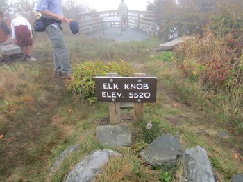
5,560' summit with view of northern highlands
|
| Park
|
Elk Knob State Park
|
| Located
|
Todd, North CarolinaLocation inherited from associated park
|
| Trail Marking
|
Blue
|
| Trail UseThings allowed to do on or near the trail
|

|
| FeaturesThings to see on or near the trail
|
 
|
| Difficulty Rating
|
Medium
|
| Hiking TimeTime from car and back. Includes any time hiking to access this trail.
|
2 hrs0.125 Days <br />120 Min <br /> round trip
|
| Distance:
|
1.829 mi2.943 km <br /> trailStrict non-repeating trail length / 3.6 mi5.794 km <br /> round tripTypical or shortest length from the car, hike the trail, and return to car
|
| Trail Type
|
In-and-Out
|
| Low / High Point
|
4,567 ft1,522.333 Yards <br />1,392.022 Meters <br /> / 5,550 ft1,850 Yards <br />1,691.64 Meters <br />
|
| Elev. Gain/LossSee link for details of calculation. Gain/Loss is direction dependent.
|
962 ft293.218 Meters <br /> / (0 ft0 Meters <br />) – West-to-East
|
| Trip ReportsFrom user "hiked it" submissions<br />Recent is within last 90 days
|
No hikes logged yet
|
| NearbyWithin 5 mi<br />Click link to view list
|
No other Trails within 5 mi
|
| Parking
|
36° 19' 54.23" N, 81° 41' 22.45" W Map
|
| Trailhead
|
36° 19' 54.23" N, 81° 41' 22.45" W Map
|
Loading map... {"type":"ROADMAP","minzoom":false,"maxzoom":false,"types":["ROADMAP","SATELLITE","HYBRID","TERRAIN"],"mappingservice":"googlemaps3","width":"100%","height":"180px","centre":false,"title":"","label":"","icon":"","lines":[],"polygons":[],"circles":[],"rectangles":[],"copycoords":false,"static":false,"visitedicon":"","wmsoverlay":false,"zoom":8,"layers":[],"controls":[""],"zoomstyle":"DEFAULT","typestyle":"DEFAULT","autoinfowindows":false,"resizable":false,"kmlrezoom":false,"poi":true,"cluster":false,"clustergridsize":60,"clustermaxzoom":20,"clusterzoomonclick":true,"clusteraveragecenter":true,"clusterminsize":2,"imageoverlays":[],"kml":[],"gkml":[],"searchmarkers":"","fullscreen":false,"scrollwheelzoom":false,"locations":[{"text":"\u003Cb\u003E\u003Cdiv class=\"mw-parser-output\"\u003E\u003Cp\u003ESummit Trail (Elk Knob)\n\u003C/p\u003E\u003C/div\u003E\u003C/b\u003E\u003Cdiv class=\"mw-parser-output\"\u003E\u003Cp\u003EMain Parking Location\n\u003C/p\u003E\u003C/div\u003E","title":"Summit Trail (Elk Knob)\n","link":"","lat":36.33173000000000030240698833949863910675048828125,"lon":-81.68957000000000334694050252437591552734375,"icon":""}]} |
| Show In Google Maps
|
Loading map...
{"format":"googlemaps3","type":"TERRAIN","minzoom":false,"maxzoom":false,"types":["SATELLITE","HYBRID","TERRAIN"],"limit":50,"offset":0,"link":"none","sort":[""],"order":[],"headers":"show","mainlabel":"","intro":"","outro":"","searchlabel":"... further results","default":"","import-annotation":false,"width":"auto","height":"600px","centre":false,"title":"","label":"","icon":"","lines":[],"polygons":[],"circles":[],"rectangles":[],"copycoords":false,"static":false,"visitedicon":"","wmsoverlay":false,"zoom":false,"layers":[],"controls":["pan","zoom","type","scale","streetview","rotate"],"zoomstyle":"DEFAULT","typestyle":"DEFAULT","autoinfowindows":false,"resizable":false,"kmlrezoom":true,"poi":true,"cluster":false,"clustergridsize":60,"clustermaxzoom":20,"clusterzoomonclick":true,"clusteraveragecenter":true,"clusterminsize":2,"imageoverlays":[],"kml":[],"gkml":["https://tehcc.org/clubwiki/images/Summit_Trail_(Elk_Knob).kml"],"searchmarkers":"","fullscreen":false,"scrollwheelzoom":false,"showtitle":false,"hidenamespace":true,"template":"Map Balloon Template","userparam":"","activeicon":"","pagelabel":false,"ajaxcoordproperty":"","ajaxquery":"","locations":[{"text":"\u003Cp\u003E\u003Cb\u003E\u003Ca class=\"mw-selflink selflink\"\u003ESummit Trail (Elk Knob)\u003C/a\u003E\u003C/b\u003E\u003Cbr /\u003E\u003C/p\u003E\u003Chr /\u003E\u003Cp\u003E1.83\u0026#160;Mi (2.94\u0026#160;km)\u003Cbr /\u003EDifficulty: Medium\u003Cbr /\u003EMarking: Blue\u003C/p\u003E","title":"Summit Trail (Elk Knob)","link":"","lat":36.33173000000000030240698833949863910675048828125,"lon":-81.68957000000000334694050252437591552734375,"icon":"/clubwiki/images/MarkerT.png"},{"text":"\u003Cp\u003E\u003Cb\u003EBench with views north\u003C/b\u003E\u003Cbr /\u003E\u003C/p\u003E\u003Chr /\u003E\u003Cp\u003E\u003Ca href=\"/wiki/File:EKSP_bench_view.jpg\" class=\"image\"\u003E\u003Cimg alt=\"EKSP bench view.jpg\" src=\"/clubwiki/images/thumb/EKSP_bench_view.jpg/150px-EKSP_bench_view.jpg\" decoding=\"async\" width=\"150\" height=\"113\" srcset=\"/clubwiki/images/thumb/EKSP_bench_view.jpg/225px-EKSP_bench_view.jpg 1.5x, /clubwiki/images/thumb/EKSP_bench_view.jpg/300px-EKSP_bench_view.jpg 2x\" data-file-width=\"1200\" data-file-height=\"900\" /\u003E\u003C/a\u003E\u003C/p\u003E","title":"Summit Trail (Elk Knob)","link":"","lat":36.33010241000000206668119062669575214385986328125,"lon":-81.680100710000004937683115713298320770263671875,"icon":"/clubwiki/images/MarkerK.png"},{"text":"\u003Cp\u003E\u003Cb\u003EInformation Center\u003C/b\u003E\u003Cbr /\u003E\u003C/p\u003E\u003Chr /\u003E\u003Cp\u003EInformation Center\u003C/p\u003E","title":"Summit Trail (Elk Knob)","link":"","lat":36.33194800929999956906613078899681568145751953125,"lon":-81.68983496219999551613000221550464630126953125,"icon":"/clubwiki/images/MarkerG.png"},{"text":"\u003Cp\u003E\u003Cb\u003ERestrooms\u003C/b\u003E\u003Cbr /\u003E\u003C/p\u003E\u003Chr /\u003E\u003Cp\u003ERestrooms\u003C/p\u003E","title":"Summit Trail (Elk Knob)","link":"","lat":36.33167084099999755153476144187152385711669921875,"lon":-81.689564956200001688557676970958709716796875,"icon":"/clubwiki/images/MarkerQ.png"},{"text":"\u003Cp\u003E\u003Cb\u003ESouth View\u003C/b\u003E\u003Cbr /\u003E\u003C/p\u003E\u003Chr /\u003E\u003Cp\u003E\u003Ca href=\"/wiki/File:EKSP_south_view.jpg\" class=\"image\"\u003E\u003Cimg alt=\"EKSP south view.jpg\" src=\"/clubwiki/images/thumb/EKSP_south_view.jpg/150px-EKSP_south_view.jpg\" decoding=\"async\" width=\"150\" height=\"113\" srcset=\"/clubwiki/images/thumb/EKSP_south_view.jpg/225px-EKSP_south_view.jpg 1.5x, /clubwiki/images/thumb/EKSP_south_view.jpg/300px-EKSP_south_view.jpg 2x\" data-file-width=\"1200\" data-file-height=\"900\" /\u003E\u003C/a\u003E\u003C/p\u003E","title":"Summit Trail (Elk Knob)","link":"","lat":36.32682585420000265230555669404566287994384765625,"lon":-81.6771597224000061032711528241634368896484375,"icon":"/clubwiki/images/MarkerB.png"},{"text":"\u003Cp\u003E\u003Cb\u003EWeather Station\u003C/b\u003E\u003Cbr /\u003E\u003C/p\u003E\u003Chr /\u003E\u003Cp\u003EWeather Station\u003C/p\u003E","title":"Summit Trail (Elk Knob)","link":"","lat":36.32714462469999716631718911230564117431640625,"lon":-81.67658424009999862391850911080837249755859375,"icon":"/clubwiki/images/MarkerM.png"},{"text":"\u003Cp\u003E\u003Cb\u003ETree growing out of a rock\u003C/b\u003E\u003Cbr /\u003E\u003C/p\u003E\u003Chr /\u003E\u003Cp\u003E\u003Ca href=\"/wiki/File:EKSP_floating_tree.jpg\" class=\"image\"\u003E\u003Cimg alt=\"EKSP floating tree.jpg\" src=\"/clubwiki/images/thumb/EKSP_floating_tree.jpg/150px-EKSP_floating_tree.jpg\" decoding=\"async\" width=\"150\" height=\"113\" srcset=\"/clubwiki/images/thumb/EKSP_floating_tree.jpg/225px-EKSP_floating_tree.jpg 1.5x, /clubwiki/images/thumb/EKSP_floating_tree.jpg/300px-EKSP_floating_tree.jpg 2x\" data-file-width=\"1200\" data-file-height=\"900\" /\u003E\u003C/a\u003E\u003C/p\u003E","title":"Summit Trail (Elk Knob)","link":"","lat":36.3294237100000003692912287078797817230224609375,"lon":-81.681933909999997922568581998348236083984375,"icon":"/clubwiki/images/MarkerG.png"},{"text":"\u003Cp\u003E\u003Cb\u003EPicnic Area\u003C/b\u003E\u003Cbr /\u003E\u003C/p\u003E\u003Chr /\u003E\u003Cp\u003EPicnic Area\u003C/p\u003E","title":"Summit Trail (Elk Knob)","link":"","lat":36.33534851520000330538096022792160511016845703125,"lon":-81.6905777120999943008428090251982212066650390625,"icon":"/clubwiki/images/MarkerS.png"},{"text":"\u003Cp\u003E\u003Cb\u003EParking and trailhead\u003C/b\u003E\u003Cbr /\u003E\u003C/p\u003E\u003Chr /\u003E\u003Cp\u003E\u003Ca href=\"/wiki/File:EKSP_trailhead.jpg\" class=\"image\"\u003E\u003Cimg alt=\"EKSP trailhead.jpg\" src=\"/clubwiki/images/thumb/EKSP_trailhead.jpg/150px-EKSP_trailhead.jpg\" decoding=\"async\" width=\"150\" height=\"113\" srcset=\"/clubwiki/images/thumb/EKSP_trailhead.jpg/225px-EKSP_trailhead.jpg 1.5x, /clubwiki/images/thumb/EKSP_trailhead.jpg/300px-EKSP_trailhead.jpg 2x\" data-file-width=\"1200\" data-file-height=\"900\" /\u003E\u003C/a\u003E\u003C/p\u003E","title":"Summit Trail (Elk Knob)","link":"","lat":36.33173000000000030240698833949863910675048828125,"lon":-81.68957000000000334694050252437591552734375,"icon":"/clubwiki/images/MarkerA.png"},{"text":"\u003Cp\u003E\u003Cb\u003EPark Office\u003C/b\u003E\u003Cbr /\u003E\u003C/p\u003E\u003Chr /\u003E\u003Cp\u003EPark Office\u003C/p\u003E","title":"Summit Trail (Elk Knob)","link":"","lat":36.33299275760000313084674417041242122650146484375,"lon":-81.69427165150000291760079562664031982421875,"icon":"/clubwiki/images/MarkerG.png"},{"text":"\u003Cp\u003E\u003Cb\u003ENorth View\u003C/b\u003E\u003Cbr /\u003E\u003C/p\u003E\u003Chr /\u003E\u003Cp\u003E\u003Ca href=\"/wiki/File:EKSP_north_view.jpg\" class=\"image\"\u003E\u003Cimg alt=\"EKSP north view.jpg\" src=\"/clubwiki/images/thumb/EKSP_north_view.jpg/150px-EKSP_north_view.jpg\" decoding=\"async\" width=\"150\" height=\"113\" srcset=\"/clubwiki/images/thumb/EKSP_north_view.jpg/225px-EKSP_north_view.jpg 1.5x, /clubwiki/images/thumb/EKSP_north_view.jpg/300px-EKSP_north_view.jpg 2x\" data-file-width=\"1200\" data-file-height=\"900\" /\u003E\u003C/a\u003E\u003C/p\u003E","title":"Summit Trail (Elk Knob)","link":"","lat":36.3272865564999989373973221518099308013916015625,"lon":-81.676483319499993740464560687541961669921875,"icon":"/clubwiki/images/MarkerB.png"}]}
Download KML / Upload new version / KML File Page / Create Profile Chart / gpsvisualizer Map
Trail Overview[edit]
Trail at the newest state park in North Carolina to 5,560' summit with view of northern highlands.
In 2002, 5540′ Elk Knob was purchased by The Nature Conservancy and later conveyed to the State of North Carolina as first a natural area, then a state park. Initially the summit could be reached by a very steep gravel road, but some excellent trail construction work has resulted in completion of a new, hardened sidehill trail not unlike the A. T. heading up Round Bald. The new trail leads 2 miles to the top of Elk Knob which has two very nice overlooks, one at the summit looking north towards Mt. Rogers and the Grayson Highlands and one a little below the top looking south towards Grandfather and Roan Mountains. This is a great wildflower hike with many trillium in early May and Gray’s lilies and flame azalea in June.
How to get there[edit]
From Johnson City, TN
Longer, but easier drive is:
- Take US321 over to Boone, NC.
- Take NC194 north out of Boone for just over four miles.
- Turn onto Meat Camp Road and travel just over five miles.
- Turn right at state park sign and enter on gravel road
- The parking area at the sharp bend in the road is the trailhead.
Park address is 5564 Meat Camp Road Todd, NC 28684-9549
Route Description[edit]
Well built, blue blaze trail to the views at the summit. New summit trail replaces the old steep rocky jeep road. The new summit trail is a longer route but has several switchbacks and thus a more gradual way to the top. As the trail winds its way up, it will cross the old road from time to time. The old jeep road is still available for hiking if you want to but the summit trail is much easier.
The north view feature spectacular views of the entire Amphibolite Range north of Boone with Mount Rogers and Whitetop in Virginia also viewable. On extremely clear days it's possible to see Pilot Mountain way off near Winston Salem.
The south view features 3 ski resorts (Beach, Sugar, Appalachian Ski), Grandfather Mountain, Roan Highlands, and the Black Mountains. On extremely clear days, it's been reported that Mount Guyot in the Smokies is visible!
| Distance (mi)
|
Feature
|
| 0.0
|
Trailhead
|
| 0.9
|
Neat tree that looks like it's growing on a rock out of thin air
|
| 1.1
|
Bench with a good view north towards "The Peak" in Ashe County
|
| 1.9
|
Trail arrives at top. Go left for the south view, go right for north view and the true summit
|
Typical Conditions[edit]
Fees, Permits, etc.[edit]
No fees at this time. Camping is not allowed.
Park Hours
November - February: 8AM - 6PM
March, April, May, September and October: 8AM - 8PM
June - August: 8AM - 9PM
Trail closes 15 minutes before the park entrance gate is locked.
After the Hike[edit]
Misc. Information[edit]
Link to state park webpage, park map, and back-country trails map.
Gallery[edit]
