|
|
| Line 123: |
Line 123: |
| == Photos == | | == Photos == |
| <gallery> | | <gallery> |
| <!-- Place any pictures from this trail below. Add a picture by typing Image:imagename.extension --> | | <!-- Place any pictures from this trail below. Ideally we would have a picture of the trailhead to help people know when they found it --> |
| Image:placeholder.jpg | | <!-- Add a picture by typing Image:imagename.extension --> |
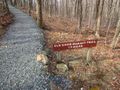
| | Image:EKSP_trailhead.jpg|Trailhead |
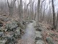
| | Image:EKSP_stonework.jpg|Well designed stonework |
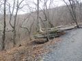
| | Image:EKSP_floating_tree.jpg|Floating tree |
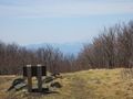
| | Image:EKSP_bench_view.jpg|Nice view while you rest on a bench |
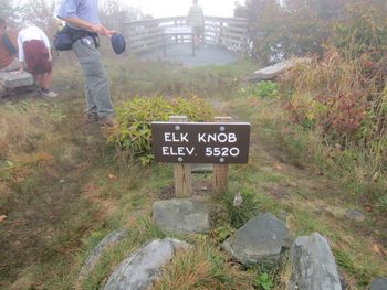
| | Image:EKSP_summit_looking_south.jpg|At the top! |
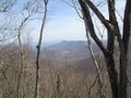
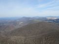
| | Image:EKSP_north_view.jpg|looking north towards the Amphibolite Range. |
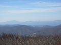
| | Image:EKSP_south_view.jpg|Looking south towards, Grandfather Mountain and Sugar Mountain |
| <!-- Do not remove the end gallery code.--> | | <!-- Do not remove the end gallery code.--> |
| </gallery> | | </gallery> |
|
| |
| <!-- Finally add the trail to any Categories it should belong to. Please keep the State category. To make a new category just type [[Category:mycategory]]. Keep in mind categories are case sensitive. --> | | <!-- Finally add the trail to any Categories it should belong to. Please keep the State category. To make a new category just type [[Category:mycategory]]. Keep in mind categories are case sensitive. --> |
| [[Category:Overlook]] [[Category:North Carolina]] [[Category:Easy]] [[Category:Dog Friendly]] | | [[Category:Overlook]] [[Category:North Carolina]] [[Category:Easy]] [[Category:Dog Friendly]] |
|
|
|
|
|
| Trail Name
|
Summit Trail (Elk Knob)
|
| Nearest City
|
Todd
|
| State
|
North Carolina
|
| Trail Marking
|
|
| Trail Use/Features
|
 
|
| Difficulty Rating
|
Easy
|
| Hiking Time
|
22 Hours <br />0.125 Days <br />120 Min <br />
|
| Distance, round-trip
|
44 mi <br />6.437 km <br />
|
| Climb/Descent Elevation
|
~900"~" is not declared as a valid unit of measurement for this property. / {{{Elevation Loss}}}"{{{Elevation Loss}}}" is not a number.
|
| High Point
|
55605,560 Feet <br />1,853.333 Yards <br />1,694.688 Meters <br />
|
| Nearest Medical
|
Boone, NC
|
| Trip Reports
|
Click Here
|
|
|
Loading map... {"type":"ROADMAP","minzoom":false,"maxzoom":false,"types":["ROADMAP","SATELLITE","HYBRID","TERRAIN"],"mappingservice":"googlemaps3","width":"270px","height":"180px","centre":false,"title":"","label":"","icon":"","lines":[],"polygons":[],"circles":[],"rectangles":[],"copycoords":false,"static":false,"visitedicon":"","wmsoverlay":false,"zoom":8,"layers":[],"controls":["zoom"],"zoomstyle":"DEFAULT","typestyle":"DEFAULT","autoinfowindows":false,"resizable":false,"kmlrezoom":false,"poi":true,"cluster":false,"clustergridsize":60,"clustermaxzoom":20,"clusterzoomonclick":true,"clusteraveragecenter":true,"clusterminsize":2,"imageoverlays":[],"kml":[],"gkml":[],"searchmarkers":"","fullscreen":false,"scrollwheelzoom":false,"locations":[{"text":"","title":"","link":"","lat":36.33173000000000030240698833949863910675048828125,"lon":-81.68957000000000334694050252437591552734375,"icon":""}]} |
|
| Show Large Map
|
|
Trail Overview
Newest state park in North Carolina with new trail being built to 5560' summit with view of northern highlands.
In 2002, 5540′ Elk Knob was purchased by The Nature Conservancy and later conveyed to the State of North Carolina as first a natural area, then a state park. Initially the summit could be reached by a very steep gravel road, but some excellent trail construction work has resulted in completion of a new, hardened sidehill trail not unlike the A. T. heading up Round Bald. The new trail leads 2 miles to the top of Elk Knob which has two very nice overlooks, one at the summit looking north towards Mt. Rogers and the Grayson Highlands and one a little below the top looking south towards Grandfather and Roan Mountains. This is a great wildflower hike with many trillium in early May and Gray’s lilies and flame azalea in June.
How to get there
From Johnson City, TN
Longer, but easier drive is:
- Take US321 over to Boone, NC.
- Take NC194 north out of Boone for just over four miles.
- Turn onto Meat Camp Road and travel just over five miles.
- Turn right at state park sign and enter on gravel road
- The parking area at the sharp bend in the road is the trailhead.
Park address is 5564 Meat Camp Road Todd, NC 28684-9549
Route Description
Well built, blue blaze trail to the views at the summit. New summit trail replaces the old steep rocky jeep road. The new summit trail is a longer route but has several switchbacks and thus a more gradual way to the top. As the trail winds its way up, it will cross the old road from time to time. The old jeep road is still available for hiking if you want to but the summit trail is much easier.
The north view feature spectacular views of the entire Amphibolite Range north of Boone with Mount Rogers and Whitetop in Virginia also viewable. On extremely clear days it's possible to see Pilot Mountain way off near Winston Salem.
The south view features 3 ski resorts (Beach, Sugar, Appalachian Ski), Grandfather Mountain, Roan Highlands, and the Black Mountains. On extremely clear days, it's been reported that Mount Guyot in the Smokies is visible!
| Distance (mi)
|
Feature
|
| 0.0
|
Trailhead
|
| 0.9
|
Neat tree that looks like it's growing on a rock out of thin air
|
| 1.1
|
Bench with a good view north towards "The Peak" in Ashe County
|
| 1.9
|
Trail arrives at top. Go left for the south view, go right for north view and the true summit
|
Typical Conditions
Newly constructed trail path just short of finishing.
Fees, Permits, etc.
No fees at this time. Camping is not allowed.
Park Hours
November - February: 8AM - 6PM
March, April, May, September and October: 8AM - 8PM
June - August: 8AM - 9PM
Trail closes 15 minutes before the park entrance gate is locked.
After the Hike
Misc. Information
Link to state park webpage, park map, and back-country trails map.
Maps
Loading map...
{"type":"TERRAIN","minzoom":false,"maxzoom":false,"types":["ROADMAP","SATELLITE","HYBRID","TERRAIN"],"mappingservice":"googlemaps3","width":"auto","height":"450px","centre":false,"title":"","label":"","icon":"","lines":[],"polygons":[],"circles":[],"rectangles":[],"copycoords":false,"static":false,"visitedicon":"","wmsoverlay":false,"zoom":false,"layers":[],"controls":["pan","zoom","type","scale","streetview","rotate"],"zoomstyle":"DEFAULT","typestyle":"DEFAULT","autoinfowindows":false,"resizable":false,"kmlrezoom":false,"poi":true,"cluster":false,"clustergridsize":60,"clustermaxzoom":20,"clusterzoomonclick":true,"clusteraveragecenter":true,"clusterminsize":2,"imageoverlays":[],"kml":[],"gkml":["http://tehcc.org/clubwiki/kml/EKSP_Summit_Trail.kml","http://tehcc.org/clubwiki/kml/EKSP_Jeep_Road.kml","http://tehcc.org/clubwiki/kml/EKSP_Backcountry_Trail.kml"],"searchmarkers":"","fullscreen":false,"scrollwheelzoom":false,"locations":[{"text":"\u003Cdiv class=\"mw-parser-output\"\u003E\u003Cp\u003ERestrooms\n\u003C/p\u003E\u003C/div\u003E","title":"Restrooms\n","link":"","lat":36.33167084099999755153476144187152385711669921875,"lon":-81.689564956200001688557676970958709716796875,"icon":"/clubwiki/images/MarkerQ.png"},{"text":"\u003Cdiv class=\"mw-parser-output\"\u003E\u003Cp\u003EInfo. Center\n\u003C/p\u003E\u003C/div\u003E","title":"Info. Center\n","link":"","lat":36.33194800929999956906613078899681568145751953125,"lon":-81.68983496219999551613000221550464630126953125,"icon":"/clubwiki/images/MarkerG.png"},{"text":"\u003Cdiv class=\"mw-parser-output\"\u003E\u003Cp\u003EPicnic Area\n\u003C/p\u003E\u003C/div\u003E","title":"Picnic Area\n","link":"","lat":36.33534851520000330538096022792160511016845703125,"lon":-81.6905777120999943008428090251982212066650390625,"icon":"/clubwiki/images/MarkerS.png"},{"text":"\u003Cdiv class=\"mw-parser-output\"\u003E\u003Cp\u003ETree growing out of a rock\n\u003C/p\u003E\u003C/div\u003E","title":"Tree growing out of a rock\n","link":"","lat":36.3294237100000003692912287078797817230224609375,"lon":-81.681933909999997922568581998348236083984375,"icon":"/clubwiki/images/MarkerG.png"},{"text":"\u003Cdiv class=\"mw-parser-output\"\u003E\u003Cp\u003EBench with views north\n\u003C/p\u003E\u003C/div\u003E","title":"Bench with views north\n","link":"","lat":36.33010241000000206668119062669575214385986328125,"lon":-81.680100710000004937683115713298320770263671875,"icon":"/clubwiki/images/MarkerK.png"},{"text":"\u003Cdiv class=\"mw-parser-output\"\u003E\u003Cp\u003ESouth View\n\u003C/p\u003E\u003C/div\u003E","title":"South View\n","link":"","lat":36.32682585420000265230555669404566287994384765625,"lon":-81.6771597224000061032711528241634368896484375,"icon":"/clubwiki/images/MarkerB.png"},{"text":"\u003Cdiv class=\"mw-parser-output\"\u003E\u003Cp\u003ENorth View\n\u003C/p\u003E\u003C/div\u003E","title":"North View\n","link":"","lat":36.3272865564999989373973221518099308013916015625,"lon":-81.676483319499993740464560687541961669921875,"icon":"/clubwiki/images/MarkerB.png"},{"text":"\u003Cdiv class=\"mw-parser-output\"\u003E\u003Cp\u003EWeather Station\n\u003C/p\u003E\u003C/div\u003E","title":"Weather Station\n","link":"","lat":36.32714462469999716631718911230564117431640625,"lon":-81.67658424009999862391850911080837249755859375,"icon":"/clubwiki/images/MarkerM.png"},{"text":"\u003Cdiv class=\"mw-parser-output\"\u003E\u003Cp\u003EPark Office\n\u003C/p\u003E\u003C/div\u003E","title":"Park Office\n","link":"","lat":36.33299275760000313084674417041242122650146484375,"lon":-81.69427165150000291760079562664031982421875,"icon":"/clubwiki/images/MarkerG.png"},{"text":"\u003Cdiv class=\"mw-parser-output\"\u003E\u003Cp\u003EParking and trailhead\n\u003C/p\u003E\u003C/div\u003E","title":"Parking and trailhead\n","link":"","lat":36.33173000000000030240698833949863910675048828125,"lon":-81.68957000000000334694050252437591552734375,"icon":"/clubwiki/images/MarkerA.png"}]}
Photos
Nice view while you rest on a bench
looking north towards the Amphibolite Range.
Looking south towards, Grandfather Mountain and Sugar Mountain