Spivey Gap (3200') is the southern boundary of the TEHCC's maintenance responsibility and where US19W cross the Trail. South of Spivey Gap, the Trail is maintained by the Carolina Mountain Club. Oglesby Branch, named after TEHCC founder Frank Oglesby, is trail north on Flattop Mountain.
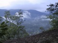
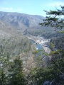
Overlooking the Nolichucky River, Cliff Ridge is the last high point before descending to the Chestoa Bridge crossing of the Nolichucky River.
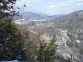
The AT meets the Nolichucky River at Chestoa Bridge. Downtown Erwin is approximately 2 miles from this point. Food, resupply, shuttles and lodging are available.
Loading map...
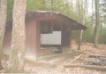
{"type":"TERRAIN","minzoom":false,"maxzoom":false,"types":["ROADMAP","SATELLITE","HYBRID","TERRAIN"],"mappingservice":"googlemaps3","width":"auto","height":"600px","centre":false,"title":"","label":"","icon":"","lines":[],"polygons":[],"circles":[],"rectangles":[],"copycoords":false,"static":false,"visitedicon":"","wmsoverlay":false,"zoom":false,"layers":[],"controls":["pan","zoom","type","scale","streetview","rotate"],"zoomstyle":"DEFAULT","typestyle":"DEFAULT","autoinfowindows":false,"resizable":false,"kmlrezoom":false,"poi":true,"cluster":false,"clustergridsize":60,"clustermaxzoom":20,"clusterzoomonclick":true,"clusteraveragecenter":true,"clusterminsize":2,"imageoverlays":[],"kml":[],"gkml":["http://tehcc.org/clubwiki/kml/Appalachian_Trail_01_Spivey_Gap_to_Nolichucky_River.kml"],"searchmarkers":"","fullscreen":false,"scrollwheelzoom":false,"locations":[{"text":"\u003Cdiv class=\"mw-parser-output\"\u003E\u003Cp\u003EChestoa Bridge\n\u003C/p\u003E\u003C/div\u003E","title":"Chestoa Bridge\n","link":"","lat":36.1054571362000018552862456999719142913818359375,"lon":-82.4478148639999943725342745892703533172607421875,"icon":"/clubwiki/images/MarkerG.png"},{"text":"\u003Cdiv class=\"mw-parser-output\"\u003E\u003Cp\u003ENo Business Knob (4,160 ft)\n\u003C/p\u003E\u003C/div\u003E","title":"No Business Knob (4,160 ft)\n","link":"","lat":36.06490000000000151203494169749319553375244140625,"lon":-82.4429999999999978399500832892954349517822265625,"icon":"/clubwiki/images/MarkerP.png"},{"text":"\u003Cdiv class=\"mw-parser-output\"\u003E\u003Cp\u003ENo Business Knob Shelter\n\u003C/p\u003E\u003C/div\u003E","title":"No Business Knob Shelter\n","link":"","lat":36.0668799689999985957911121658980846405029296875,"lon":-82.433451017999999521634890697896480560302734375,"icon":"/clubwiki/images/MarkerF.png"},{"text":"\u003Cdiv class=\"mw-parser-output\"\u003E\u003Cp\u003ETemple Hill (3,710 ft)\n\u003C/p\u003E\u003C/div\u003E","title":"Temple Hill (3,710 ft)\n","link":"","lat":36.0801000000000016143530956469476222991943359375,"lon":-82.4608999999999952024154481478035449981689453125,"icon":"/clubwiki/images/MarkerP.png"}]}