Spivey Gap to Nolichucky River: Difference between revisions
(Added southern end coordindates on gmap will function) |
No edit summary |
||
| Line 7: | Line 7: | ||
| Distance = 11.2 | | Distance = 11.2 | ||
| Min_elevation = 1,700 | | Min_elevation = 1,700 | ||
| Max_elevation = | | Max_elevation = 3,901 | ||
| Governing = Unaka | | Governing = Unaka | ||
| Latitude = 36.03198 | | Latitude = 36.03198 | ||
| Line 33: | Line 33: | ||
The AT meets the Nolichucky River at Chestoa Bridge. Downtown Erwin is approximately 2 miles from this point. Food, resupply, shuttles and lodging are available. | The AT meets the Nolichucky River at Chestoa Bridge. Downtown Erwin is approximately 2 miles from this point. Food, resupply, shuttles and lodging are available. | ||
== Maps == | |||
<!-- You can place pictures, PDF's, links, or even create a Google map with your waypoints and place it here. --> | |||
<display_map type="terrain" width="auto" height="600" gkml="http://tehcc.org/clubwiki/kml/Appalachian_Trail_01_Spivey_Gap_to_Nolichucky_River.kml"> | |||
36.1054571362, -82.447814864~Chestoa Bridge~ ~MarkerG.png | |||
36.0649000000, -82.443000000~No Business Knob (4,160 ft)~ ~MarkerP.png | |||
36.0668799690, -82.433451018~No Business Knob Shelter~ ~MarkerF.png | |||
36.0801000000, -82.460900000~Temple Hill (3,710 ft)~ ~MarkerP.png | |||
</display_map> | |||
<gallery> | <gallery> | ||
Revision as of 13:15, 19 May 2016

| ||
| Section | 20a/b | |
| Trail south point | Spivey Gap | |
| Trail north point | Nolichucky River | |
| Distance | 11.2 Miles | |
| Min Elevation | 1,700 Feet | |
| Max Elevation | 3,901 Feet | |
| Governing Body | Unaka | |
|
|
||
| Show Large Map | ||
(Trail South > North)
Spivey Gap
Spivey Gap (3200') is the southern boundary of the TEHCC's maintenance responsibility and where US19W cross the Trail. South of Spivey Gap, the Trail is maintained by the Carolina Mountain Club. Oglesby Branch, named after TEHCC founder Frank Oglesby, is trail north on Flattop Mountain.
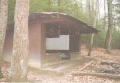
No Business Knob Shelter
No Business Knob Shelter (3251') is a concrete block shelter built in 1963 by the United States Forest Service.
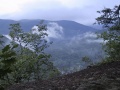
Cliff Ridge
Overlooking the Nolichucky River, Cliff Ridge is the last high point before descending to the Chestoa Bridge crossing of the Nolichucky River.
Nolichucky River and Erwin, TN
The AT meets the Nolichucky River at Chestoa Bridge. Downtown Erwin is approximately 2 miles from this point. Food, resupply, shuttles and lodging are available.
Maps
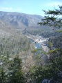
Nolichucky River Gorge
No Business Knob Shelter

White Rhododendron
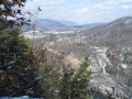
Spivey Gap as viewed from Temple Hill
Spivey Gap as viewed from Temple Hill


