South Holston Dam: Difference between revisions
m (Text replacement - "http://tehcc.org/clubwiki/" to "https://tehcc.org/clubwiki/") |
|||
| (20 intermediate revisions by 3 users not shown) | |||
| Line 1: | Line 1: | ||
<!-- The following few lines create the "Infobox" table template. Please scroll down to edit the main content of the article. --> | <!-- The following few lines create the "Infobox" table template. Please scroll down to edit the main content of the article. | ||
{{Infobox Trail | |||
| Image Name = | -->{{Infobox Trail | ||
| Image Name = South Holston Dam1.JPG | |||
| City = Bristol | | City = Bristol | ||
| State = Tennessee | | State = Tennessee | ||
| Trail Use = {{Hike}} {{Biking}} {{Dogs}} | | Marking = None | ||
| Trail Use = {{Hike}} {{Biking}} {{Dogs}} {{Fishing}} | |||
| Difficulty Rating = Easy | | Difficulty Rating = Easy | ||
| Hike Time = | | Hike Time = 1.5 | ||
| Distance = | | Distance = 3.4 | ||
| Elevation Gain = | | Elevation Gain = 265 | ||
| High Point = | | High Point = 1903 | ||
| Latitude = | | Latitude = 36.51741 | ||
| Longitude = | | Longitude = -82.08995 | ||
| Medical = Bristol, TN | | Medical = Bristol, TN | ||
<!-- | }}<!-- | ||
End Infobox template table | |||
<!-- | -->{{Trail page needs | ||
| Hide needs = | |||
| KML = | |||
| Updated KML = | |||
| Detail route description = | |||
| Photos = | |||
| Winter photos = | |||
| Remove prefix = | |||
| Update infobox = Yes | |||
| Infobox data update = Yes | |||
| Trail pins = | |||
| Other = | |||
| Comment = Just needs update to new page/template formats | |||
| Date reviewed = 11/22/2015 | |||
}}<!-- | |||
Start of Main Page --> | |||
== Trail Overview == | == Trail Overview == | ||
<!-- Enter a overview of the trail. What attracts you to this trail, points of interest, types of flowers, lakes, and peaks that you see along the way. --> | <!-- Enter a overview of the trail. What attracts you to this trail, points of interest, types of flowers, lakes, and peaks that you see along the way. --> | ||
Probably better known as the South Holston Spillway Trail, this is an easy family hike with views of South Holston Lake. | |||
== How to get there == | == How to get there == | ||
| Line 31: | Line 44: | ||
From Kingsport, TN | From Kingsport, TN | ||
# Take I-81 north to Exit 69 (TN394/Blountville). | # Take I-81 north to Exit 69 (TN394/Blountville). | ||
# Turn right/east onto TN394 and travel 12 miles. | # Turn right/east onto TN394 and travel 12 miles (passing Bristol Motor Speedway). | ||
# Take right/ | # Take right/south onto US421 and travel 3 miles. | ||
# Turn right/south onto Emmett Road and travel 1 mile. | # Turn right/south onto Emmett Road (South Holston Dam sign) and travel 1 mile. | ||
# | # Veer right/south onto Holston View Dam Road and travel 1 mile. | ||
# At base of dam, take South Holston Dam Road up the right side. | # At base of dam, take sharp right onto South Holston Dam Road up the right side. | ||
# Pass a small picnic area on left (Note: This is not | # Pass a small picnic area on left (Note: This is not the main, large picnic area near the visitors' center.) | ||
# Parking is at the small pulloff on the right before reaching the top of the dam. | # Parking is at the small gravel pulloff on the right before reaching the top of the dam. | ||
Space for half dozen correctly parked vehicles, else park uphill no grassy shoulder or back down in picnic area. | |||
== Route Description== | == Route Description== | ||
<!-- Detailed description of the route. Is there any side trails that are worth traveling? --> | <!-- Detailed description of the route. Is there any side trails that are worth traveling? --> | ||
Starting at the parking area, walk past | Starting at the parking area, walk past boulder and cable barrier onto gravel roadway. Follow road south up and over ridge to walk along the lake shore until it ends at the spillway. Return by same path. No blazes or signs. | ||
{| class="wikitable" border="1" | |||
|- | |||
!Miles | |||
!Elevation | |||
!South Holston Spillway | |||
|- | |||
|0.0 | |||
|1640 | |||
|Trailhead | |||
|- | |||
|0.9 | |||
|1900 | |||
|Highpoint | |||
|- | |||
|1.7 | |||
|1760 | |||
|Spillway | |||
|} | |||
Family idea: When the water level is down, the shore below the spillway has lots of smooth, flat shale rocks, which are great for skipping across the lake. Challenge the kids to a "number of skips" contest. | |||
== Typical Conditions == | == Typical Conditions == | ||
<!-- Typical conditions throughout the year of what to expect on the trail. Rocky, muddy, sandy, flowers, lots of downed trees? --> | <!-- Typical conditions throughout the year of what to expect on the trail. Rocky, muddy, sandy, flowers, lots of downed trees? --> | ||
Shaded | Shaded gravel road, generally dual tracks, thus suitable for bikes or walking. Forest Service appears to run a bushhog up and back to keep the grass cut low. | ||
== Fees, Permits, etc. == | == Fees, Permits, etc. == | ||
| Line 51: | Line 86: | ||
No fee to use. | No fee to use. | ||
== After the Hike == | == Before/After the Hike == | ||
<!-- Other things to check out while you're in the area. Restaurants, attractions, monuments, etc... --> | <!-- Other things to check out while you're in the area. Restaurants, attractions, monuments, etc... --> | ||
Visitors' Center on north side of the dam offers a nice view of the lake - and very basic bathroom facilities. | |||
== Misc. Information == | == Misc. Information == | ||
<!-- Enter any additional information that doesn't fit an any other fields. Any seasonal features, factoids, etc...? --> | <!-- Enter any additional information that doesn't fit an any other fields. Any seasonal features, factoids, etc...? --> | ||
The reservoir is created by a TVA dam on the South Fork Holston River. Construction of the dam was started in 1942, but halted due to WWII, and finally completed in 1950. The earth-and-rock fill dam is 285 feet high and 1,600 feet long. | The reservoir is created by a TVA dam on the South Fork Holston River. Construction of the dam was started in 1942, but halted due to WWII, and finally completed in 1950. The earth-and-rock fill dam is 285 feet high and 1,600 feet long. The purpose of the spillway is to protect the main earthen dam in case the lake level rises quickly. | ||
== Maps == | == Maps == | ||
<!-- You can place pictures, PDF's, links, or even create a Google map with your waypoints and place it here. --> | <!-- You can place pictures, PDF's, links, or even create a Google map with your waypoints and place it here. --> | ||
< | <display_map center="36.5150,-82.0910" type="terrain" height="500" width="auto" zoom="14" gkml="https://tehcc.org/clubwiki/kml/South_Holston_Dam_spillway.kml"> | ||
36.52118,-82.09117~Small picnic area~ ~MarkerS.png | |||
36.5279,-82.0867~Large picnic area across dam~ ~MarkerS.png | |||
36.51741,-82.08995~Parking at trailhead~[[Image:South Holston Spillway Trailhead.JPG|150px]]~MarkerA.png | |||
Parking | 36.5,-82.0960~Spillway~[[Image:South_Holston_Spillway.JPG|150px]]~MarkerG.png | ||
36.5255,-82.0879~Visitors' center~ ~MarkerQ.png | |||
</display_map> | |||
</ | |||
== Photos == | == Photos == | ||
| Line 75: | Line 109: | ||
<!-- Place any pictures from this trail below. Ideally we would have a picture of the trailhead to help people know when they found it --> | <!-- Place any pictures from this trail below. Ideally we would have a picture of the trailhead to help people know when they found it --> | ||
<!-- Add a picture by typing Image:imagename.extension --> | <!-- Add a picture by typing Image:imagename.extension --> | ||
Image: | Image:South_Holston_Spillway.JPG|Spillway viewed from upon rim | ||
Image:South_Holston_Spillway2.JPG|Viewed from shore | |||
Image:South Holston Lake.JPG|Lake as seen from along trail | |||
Image:South Holston Spillway Trail.JPG|South Holston Spillway Trail | |||
Image:South Holston Spillway Trailhead.JPG|Trailhead at parking lot | |||
<!-- Do not remove the end gallery code.--> | <!-- Do not remove the end gallery code.--> | ||
</gallery> | </gallery> | ||
<!-- Finally add the trail to any Categories it should belong to. | <!-- Finally add the trail to any Categories it should belong to. Keep in mind categories are case sensitive. --> | ||
[[Category:Tennessee]] [[Category:Hiking]] [[Category:Biking]] [[Category:Easy]] [[Category:Dog Friendly]] | [[Category:Tennessee]] [[Category:Hiking]] [[Category:Biking]] [[Category:Easy]] [[Category:Dog Friendly]] [[Category:Fishing]] | ||
Latest revision as of 12:12, 7 January 2023
| |||||||||||||||||||||||||||||||||||||

Trail Overview[edit]
Probably better known as the South Holston Spillway Trail, this is an easy family hike with views of South Holston Lake.
How to get there[edit]
From Kingsport, TN
- Take I-81 north to Exit 69 (TN394/Blountville).
- Turn right/east onto TN394 and travel 12 miles (passing Bristol Motor Speedway).
- Take right/south onto US421 and travel 3 miles.
- Turn right/south onto Emmett Road (South Holston Dam sign) and travel 1 mile.
- Veer right/south onto Holston View Dam Road and travel 1 mile.
- At base of dam, take sharp right onto South Holston Dam Road up the right side.
- Pass a small picnic area on left (Note: This is not the main, large picnic area near the visitors' center.)
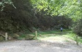
- Parking is at the small gravel pulloff on the right before reaching the top of the dam.
Space for half dozen correctly parked vehicles, else park uphill no grassy shoulder or back down in picnic area.
Route Description[edit]
Starting at the parking area, walk past boulder and cable barrier onto gravel roadway. Follow road south up and over ridge to walk along the lake shore until it ends at the spillway. Return by same path. No blazes or signs.
| Miles | Elevation | South Holston Spillway |
|---|---|---|
| 0.0 | 1640 | Trailhead |
| 0.9 | 1900 | Highpoint |
| 1.7 | 1760 | Spillway |
Family idea: When the water level is down, the shore below the spillway has lots of smooth, flat shale rocks, which are great for skipping across the lake. Challenge the kids to a "number of skips" contest.
Typical Conditions[edit]
Shaded gravel road, generally dual tracks, thus suitable for bikes or walking. Forest Service appears to run a bushhog up and back to keep the grass cut low.
Fees, Permits, etc.[edit]
No fee to use.
Before/After the Hike[edit]
Visitors' Center on north side of the dam offers a nice view of the lake - and very basic bathroom facilities.
Misc. Information[edit]
The reservoir is created by a TVA dam on the South Fork Holston River. Construction of the dam was started in 1942, but halted due to WWII, and finally completed in 1950. The earth-and-rock fill dam is 285 feet high and 1,600 feet long. The purpose of the spillway is to protect the main earthen dam in case the lake level rises quickly.
Maps[edit]
Photos[edit]
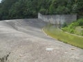
Spillway viewed from upon rim
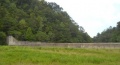
Viewed from shore
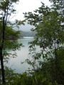
Lake as seen from along trail
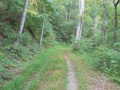
South Holston Spillway Trail
Trailhead at parking lot


