Loading map...
{"format":"googlemaps3","type":"TERRAIN","minzoom":false,"maxzoom":false,"types":["SATELLITE","HYBRID","TERRAIN"],"limit":50,"offset":0,"link":"none","sort":[""],"order":[],"headers":"show","mainlabel":"","intro":"","outro":"","searchlabel":"... further results","default":"","import-annotation":false,"width":"auto","height":"600px","centre":false,"title":"","label":"","icon":"","lines":[],"polygons":[],"circles":[],"rectangles":[],"copycoords":false,"static":false,"visitedicon":"","wmsoverlay":false,"zoom":false,"layers":[],"controls":["pan","zoom","type","scale","streetview","rotate"],"zoomstyle":"DEFAULT","typestyle":"DEFAULT","autoinfowindows":false,"resizable":false,"kmlrezoom":true,"poi":true,"cluster":false,"clustergridsize":60,"clustermaxzoom":20,"clusterzoomonclick":true,"clusteraveragecenter":true,"clusterminsize":2,"imageoverlays":[],"kml":[],"gkml":["https://tehcc.org/clubwiki/images/Sinking_Waters.kml"],"searchmarkers":"","fullscreen":false,"scrollwheelzoom":false,"showtitle":false,"hidenamespace":true,"template":"Map Balloon Template","userparam":"","activeicon":"","pagelabel":false,"ajaxcoordproperty":"","ajaxquery":"","locations":[{"text":"\u003Cp\u003E\u003Cb\u003E\u003Ca class=\"mw-selflink selflink\"\u003ESinking Waters\u003C/a\u003E\u003C/b\u003E\u003Cbr /\u003E\u003C/p\u003E\u003Chr /\u003E\u003Cp\u003E1.75\u0026#160;Mi (2.82\u0026#160;km)\u003Cbr /\u003EDifficulty: Easy\u003Cbr /\u003EMarking: Green, Yellow, Blue\u003C/p\u003E","title":"Sinking Waters","link":"","lat":36.51659000000000077079675975255668163299560546875,"lon":-82.4736599999999953070073388516902923583984375,"icon":"/clubwiki/images/MarkerT.png"},{"text":"\u003Cp\u003E\u003Cb\u003ETrail sign\u003C/b\u003E\u003Cbr /\u003E\u003C/p\u003E\u003Chr /\u003E\u003Cp\u003E\u003Ca href=\"/wiki/File:WPSP_SW_sign_on_NorthEast_loop.jpg\" class=\"image\" title=\"Sign on ridge of the first loop\"\u003E\u003Cimg alt=\"Sign on ridge of the first loop\" src=\"/clubwiki/images/thumb/WPSP_SW_sign_on_NorthEast_loop.jpg/150px-WPSP_SW_sign_on_NorthEast_loop.jpg\" decoding=\"async\" width=\"150\" height=\"113\" srcset=\"/clubwiki/images/thumb/WPSP_SW_sign_on_NorthEast_loop.jpg/225px-WPSP_SW_sign_on_NorthEast_loop.jpg 1.5x, /clubwiki/images/thumb/WPSP_SW_sign_on_NorthEast_loop.jpg/300px-WPSP_SW_sign_on_NorthEast_loop.jpg 2x\" data-file-width=\"1280\" data-file-height=\"960\" /\u003E\u003C/a\u003E\u003C/p\u003E","title":"Sinking Waters","link":"","lat":36.51596500000000133923094836063683032989501953125,"lon":-82.477991000000002941305865533649921417236328125,"icon":"/clubwiki/images/MarkerG.png"},{"text":"\u003Cp\u003E\u003Cb\u003ECollapsed shed\u003C/b\u003E\u003Cbr /\u003E\u003C/p\u003E\u003Chr /\u003E\u003Cp\u003E\u003Ca href=\"/wiki/File:WPSP_SW_Collapsed_shed_1.jpg\" class=\"image\" title=\"Collapsed shed\"\u003E\u003Cimg alt=\"Collapsed shed\" src=\"/clubwiki/images/thumb/WPSP_SW_Collapsed_shed_1.jpg/150px-WPSP_SW_Collapsed_shed_1.jpg\" decoding=\"async\" width=\"150\" height=\"113\" srcset=\"/clubwiki/images/thumb/WPSP_SW_Collapsed_shed_1.jpg/225px-WPSP_SW_Collapsed_shed_1.jpg 1.5x, /clubwiki/images/thumb/WPSP_SW_Collapsed_shed_1.jpg/300px-WPSP_SW_Collapsed_shed_1.jpg 2x\" data-file-width=\"1280\" data-file-height=\"960\" /\u003E\u003C/a\u003E\u003C/p\u003E","title":"Sinking Waters","link":"","lat":36.5084269999999975198079482652246952056884765625,"lon":-82.4814889999999962810761644504964351654052734375,"icon":"/clubwiki/images/MarkerV.png"},{"text":"\u003Cp\u003E\u003Cb\u003EBench\u003C/b\u003E\u003Cbr /\u003E\u003C/p\u003E\u003Chr /\u003E\u003Cp\u003E\u003Ca href=\"/wiki/File:WPSP_SW_bench_at_2nd_loop_split.jpg\" class=\"image\" title=\"Bench\"\u003E\u003Cimg alt=\"Bench\" src=\"/clubwiki/images/thumb/WPSP_SW_bench_at_2nd_loop_split.jpg/150px-WPSP_SW_bench_at_2nd_loop_split.jpg\" decoding=\"async\" width=\"150\" height=\"113\" srcset=\"/clubwiki/images/thumb/WPSP_SW_bench_at_2nd_loop_split.jpg/225px-WPSP_SW_bench_at_2nd_loop_split.jpg 1.5x, /clubwiki/images/thumb/WPSP_SW_bench_at_2nd_loop_split.jpg/300px-WPSP_SW_bench_at_2nd_loop_split.jpg 2x\" data-file-width=\"1280\" data-file-height=\"960\" /\u003E\u003C/a\u003E\u003C/p\u003E","title":"Sinking Waters","link":"","lat":36.51350699999999704914444009773433208465576171875,"lon":-82.47773399999999810461304150521755218505859375,"icon":"/clubwiki/images/MarkerK.png"},{"text":"\u003Cp\u003E\u003Cb\u003EBench\u003C/b\u003E\u003Cbr /\u003E\u003C/p\u003E\u003Chr /\u003E\u003Cp\u003E\u003Ca href=\"/wiki/File:WPSP_SW_bench_on_North_middle_loop.jpg\" class=\"image\" title=\"Bench on North leg of 2nd loop\"\u003E\u003Cimg alt=\"Bench on North leg of 2nd loop\" src=\"/clubwiki/images/thumb/WPSP_SW_bench_on_North_middle_loop.jpg/150px-WPSP_SW_bench_on_North_middle_loop.jpg\" decoding=\"async\" width=\"150\" height=\"113\" srcset=\"/clubwiki/images/thumb/WPSP_SW_bench_on_North_middle_loop.jpg/225px-WPSP_SW_bench_on_North_middle_loop.jpg 1.5x, /clubwiki/images/thumb/WPSP_SW_bench_on_North_middle_loop.jpg/300px-WPSP_SW_bench_on_North_middle_loop.jpg 2x\" data-file-width=\"1280\" data-file-height=\"960\" /\u003E\u003C/a\u003E\u003C/p\u003E","title":"Sinking Waters","link":"","lat":36.51375600000000076761352829635143280029296875,"lon":-82.4791500000000041836756281554698944091796875,"icon":"/clubwiki/images/MarkerK.png"},{"text":"\u003Cp\u003E\u003Cb\u003EThe Sinking Waters\u003C/b\u003E\u003Cbr /\u003E\u003C/p\u003E\u003Chr /\u003E\u003Cp\u003E\u003Ca href=\"/wiki/File:Sinking_Waters_sinkhole.jpg\" class=\"image\" title=\"The namesake sinking waters disappearing into a hole\"\u003E\u003Cimg alt=\"The namesake sinking waters disappearing into a hole\" src=\"/clubwiki/images/thumb/Sinking_Waters_sinkhole.jpg/150px-Sinking_Waters_sinkhole.jpg\" decoding=\"async\" width=\"150\" height=\"113\" srcset=\"/clubwiki/images/thumb/Sinking_Waters_sinkhole.jpg/225px-Sinking_Waters_sinkhole.jpg 1.5x, /clubwiki/images/thumb/Sinking_Waters_sinkhole.jpg/300px-Sinking_Waters_sinkhole.jpg 2x\" data-file-width=\"2048\" data-file-height=\"1536\" /\u003E\u003C/a\u003E\u003Cbr /\u003EThe namesake sinking waters\u003Cbr /\u003Edisappearing into a hole\u003C/p\u003E","title":"Sinking Waters","link":"","lat":36.51004999999999967030817060731351375579833984375,"lon":-82.4812749999999965666575008071959018707275390625,"icon":"/clubwiki/images/MarkerB.png"},{"text":"\u003Cp\u003E\u003Cb\u003ETrail stairs\u003C/b\u003E\u003Cbr /\u003E\u003C/p\u003E\u003Chr /\u003E\u003Cp\u003E\u003Ca href=\"/wiki/File:WPSP_SW_stairs.jpg\" class=\"image\" title=\"Stairs coming off of the ridge\"\u003E\u003Cimg alt=\"Stairs coming off of the ridge\" src=\"/clubwiki/images/thumb/WPSP_SW_stairs.jpg/150px-WPSP_SW_stairs.jpg\" decoding=\"async\" width=\"150\" height=\"200\" srcset=\"/clubwiki/images/thumb/WPSP_SW_stairs.jpg/225px-WPSP_SW_stairs.jpg 1.5x, /clubwiki/images/thumb/WPSP_SW_stairs.jpg/300px-WPSP_SW_stairs.jpg 2x\" data-file-width=\"768\" data-file-height=\"1024\" /\u003E\u003C/a\u003E\u003C/p\u003E","title":"Sinking Waters","link":"","lat":36.51483600000000251384335570037364959716796875,"lon":-82.4773650000000060344973462633788585662841796875,"icon":"/clubwiki/images/MarkerG.png"},{"text":"\u003Cp\u003E\u003Cb\u003EUnmarked trail turn\u003C/b\u003E\u003Cbr /\u003E\u003C/p\u003E\u003Chr /\u003E\u003Cp\u003EMust turn right uphill or left to follow the creek on your right to continue in the correct direction. Not sure where the other path will take you\u003C/p\u003E","title":"Sinking Waters","link":"","lat":36.51294500000000198269844986498355865478515625,"lon":-82.4809609999999935325831756927073001861572265625,"icon":"/clubwiki/images/MarkerT.png"},{"text":"\u003Cp\u003E\u003Cb\u003ETrail sign\u003C/b\u003E\u003Cbr /\u003E\u003C/p\u003E\u003Chr /\u003E\u003Cp\u003E\u003Ca href=\"/wiki/File:WPSP_SW_trail_sign_near_stairs.jpg\" class=\"image\" title=\"Sign near stairs of 1st loop rejoining\"\u003E\u003Cimg alt=\"Sign near stairs of 1st loop rejoining\" src=\"/clubwiki/images/thumb/WPSP_SW_trail_sign_near_stairs.jpg/150px-WPSP_SW_trail_sign_near_stairs.jpg\" decoding=\"async\" width=\"150\" height=\"113\" srcset=\"/clubwiki/images/thumb/WPSP_SW_trail_sign_near_stairs.jpg/225px-WPSP_SW_trail_sign_near_stairs.jpg 1.5x, /clubwiki/images/thumb/WPSP_SW_trail_sign_near_stairs.jpg/300px-WPSP_SW_trail_sign_near_stairs.jpg 2x\" data-file-width=\"1280\" data-file-height=\"960\" /\u003E\u003C/a\u003E\u003C/p\u003E","title":"Sinking Waters","link":"","lat":36.51429999999999864712663111276924610137939453125,"lon":-82.47683399999999664942151866853237152099609375,"icon":"/clubwiki/images/MarkerG.png"},{"text":"\u003Cp\u003E\u003Cb\u003ETrail sign\u003C/b\u003E\u003Cbr /\u003E\u003C/p\u003E\u003Chr /\u003E\u003Cp\u003E\u003Ca href=\"/wiki/File:WPSP_SW_Sign_on_SouthEast_Loop.jpg\" class=\"image\" title=\"Sign on south end of the first loop\"\u003E\u003Cimg alt=\"Sign on south end of the first loop\" src=\"/clubwiki/images/thumb/WPSP_SW_Sign_on_SouthEast_Loop.jpg/150px-WPSP_SW_Sign_on_SouthEast_Loop.jpg\" decoding=\"async\" width=\"150\" height=\"113\" srcset=\"/clubwiki/images/thumb/WPSP_SW_Sign_on_SouthEast_Loop.jpg/225px-WPSP_SW_Sign_on_SouthEast_Loop.jpg 1.5x, /clubwiki/images/thumb/WPSP_SW_Sign_on_SouthEast_Loop.jpg/300px-WPSP_SW_Sign_on_SouthEast_Loop.jpg 2x\" data-file-width=\"1280\" data-file-height=\"960\" /\u003E\u003C/a\u003E\u003C/p\u003E","title":"Sinking Waters","link":"","lat":36.51590999999999809233486303128302097320556640625,"lon":-82.475132999999999583451426587998867034912109375,"icon":"/clubwiki/images/MarkerG.png"},{"text":"\u003Cp\u003E\u003Cb\u003ETrail signs\u003C/b\u003E\u003Cbr /\u003E\u003C/p\u003E\u003Chr /\u003E\u003Cp\u003E\u003Ca href=\"/wiki/File:WPSP_SW_boardwalk_sign_front.jpg\" class=\"image\" title=\"Front side of boardwalk sign\"\u003E\u003Cimg alt=\"Front side of boardwalk sign\" src=\"/clubwiki/images/thumb/WPSP_SW_boardwalk_sign_front.jpg/150px-WPSP_SW_boardwalk_sign_front.jpg\" decoding=\"async\" width=\"150\" height=\"113\" srcset=\"/clubwiki/images/thumb/WPSP_SW_boardwalk_sign_front.jpg/225px-WPSP_SW_boardwalk_sign_front.jpg 1.5x, /clubwiki/images/thumb/WPSP_SW_boardwalk_sign_front.jpg/300px-WPSP_SW_boardwalk_sign_front.jpg 2x\" data-file-width=\"1280\" data-file-height=\"960\" /\u003E\u003C/a\u003E\u003Cbr /\u003E\u003Ca href=\"/wiki/File:WPSP_SW_Boardwalk_sign_back.jpg\" class=\"image\" title=\"Back side of boardwalk sign\"\u003E\u003Cimg alt=\"Back side of boardwalk sign\" src=\"/clubwiki/images/thumb/WPSP_SW_Boardwalk_sign_back.jpg/150px-WPSP_SW_Boardwalk_sign_back.jpg\" decoding=\"async\" width=\"150\" height=\"113\" srcset=\"/clubwiki/images/thumb/WPSP_SW_Boardwalk_sign_back.jpg/225px-WPSP_SW_Boardwalk_sign_back.jpg 1.5x, /clubwiki/images/thumb/WPSP_SW_Boardwalk_sign_back.jpg/300px-WPSP_SW_Boardwalk_sign_back.jpg 2x\" data-file-width=\"1280\" data-file-height=\"960\" /\u003E\u003C/a\u003E\u003C/p\u003E","title":"Sinking Waters","link":"","lat":36.51068599999999975125319906510412693023681640625,"lon":-82.481055999999995265170582570135593414306640625,"icon":"/clubwiki/images/MarkerG.png"},{"text":"\u003Cp\u003E\u003Cb\u003ETrail sign\u003C/b\u003E\u003Cbr /\u003E\u003C/p\u003E\u003Chr /\u003E\u003Cp\u003E\u003Ca href=\"/wiki/File:WPSP_SW_Sign_on_South_mid_loop.jpg\" class=\"image\" title=\"Sign on south end of the middle loop\"\u003E\u003Cimg alt=\"Sign on south end of the middle loop\" src=\"/clubwiki/images/thumb/WPSP_SW_Sign_on_South_mid_loop.jpg/150px-WPSP_SW_Sign_on_South_mid_loop.jpg\" decoding=\"async\" width=\"150\" height=\"113\" srcset=\"/clubwiki/images/thumb/WPSP_SW_Sign_on_South_mid_loop.jpg/225px-WPSP_SW_Sign_on_South_mid_loop.jpg 1.5x, /clubwiki/images/thumb/WPSP_SW_Sign_on_South_mid_loop.jpg/300px-WPSP_SW_Sign_on_South_mid_loop.jpg 2x\" data-file-width=\"1280\" data-file-height=\"960\" /\u003E\u003C/a\u003E\u003C/p\u003E","title":"Sinking Waters","link":"","lat":36.5123109999999968522388371638953685760498046875,"lon":-82.4796649999999971214492688886821269989013671875,"icon":"/clubwiki/images/MarkerG.png"},{"text":"\u003Cp\u003E\u003Cb\u003EWater bridge\u003C/b\u003E\u003Cbr /\u003E\u003C/p\u003E\u003Chr /\u003E\u003Cp\u003E\u003Ca href=\"/wiki/File:WPSP_SW_bridge.jpg\" class=\"image\" title=\"Bridge near parking\"\u003E\u003Cimg alt=\"Bridge near parking\" src=\"/clubwiki/images/thumb/WPSP_SW_bridge.jpg/150px-WPSP_SW_bridge.jpg\" decoding=\"async\" width=\"150\" height=\"113\" srcset=\"/clubwiki/images/thumb/WPSP_SW_bridge.jpg/225px-WPSP_SW_bridge.jpg 1.5x, /clubwiki/images/thumb/WPSP_SW_bridge.jpg/300px-WPSP_SW_bridge.jpg 2x\" data-file-width=\"1280\" data-file-height=\"960\" /\u003E\u003C/a\u003E\u003C/p\u003E","title":"Sinking Waters","link":"","lat":36.51640400000000141744749271310865879058837890625,"lon":-82.4743160000000017362253856845200061798095703125,"icon":"/clubwiki/images/MarkerL.png"},{"text":"\u003Cp\u003E\u003Cb\u003EParking and trail head\u003C/b\u003E\u003Cbr /\u003E\u003C/p\u003E\u003Chr /\u003E\u003Cp\u003E\u003Ca href=\"/wiki/File:WPSP_SW_parking_lot.jpg\" class=\"image\" title=\"Parking lot sign\"\u003E\u003Cimg alt=\"Parking lot sign\" src=\"/clubwiki/images/thumb/WPSP_SW_parking_lot.jpg/150px-WPSP_SW_parking_lot.jpg\" decoding=\"async\" width=\"150\" height=\"83\" srcset=\"/clubwiki/images/thumb/WPSP_SW_parking_lot.jpg/225px-WPSP_SW_parking_lot.jpg 1.5x, /clubwiki/images/thumb/WPSP_SW_parking_lot.jpg/300px-WPSP_SW_parking_lot.jpg 2x\" data-file-width=\"1280\" data-file-height=\"705\" /\u003E\u003C/a\u003E\u003C/p\u003E","title":"Sinking Waters","link":"","lat":36.51659099999999824603946763090789318084716796875,"lon":-82.4736649999999968940755934454500675201416015625,"icon":"/clubwiki/images/MarkerA.png"},{"text":"\u003Cp\u003E\u003Cb\u003ETrail sign\u003C/b\u003E\u003Cbr /\u003E\u003C/p\u003E\u003Chr /\u003E\u003Cp\u003E\u003Ca href=\"/wiki/File:WPSP_SW_Golf_Course_Entrance.jpg\" class=\"image\" title=\"Golf Course Entrance sign\"\u003E\u003Cimg alt=\"Golf Course Entrance sign\" src=\"/clubwiki/images/thumb/WPSP_SW_Golf_Course_Entrance.jpg/150px-WPSP_SW_Golf_Course_Entrance.jpg\" decoding=\"async\" width=\"150\" height=\"113\" srcset=\"/clubwiki/images/thumb/WPSP_SW_Golf_Course_Entrance.jpg/225px-WPSP_SW_Golf_Course_Entrance.jpg 1.5x, /clubwiki/images/thumb/WPSP_SW_Golf_Course_Entrance.jpg/300px-WPSP_SW_Golf_Course_Entrance.jpg 2x\" data-file-width=\"1280\" data-file-height=\"960\" /\u003E\u003C/a\u003E\u003C/p\u003E","title":"Sinking Waters","link":"","lat":36.5091579999999993333403836004436016082763671875,"lon":-82.4814300000000031332092476077377796173095703125,"icon":"/clubwiki/images/MarkerG.png"},{"text":"\u003Cp\u003E\u003Cb\u003ETrail sign\u003C/b\u003E\u003Cbr /\u003E\u003C/p\u003E\u003Chr /\u003E\u003Cp\u003E\u003Ca href=\"/wiki/File:WPSP_SW_sign_at_mid_loop_rejoin.jpg\" class=\"image\" title=\"Sign between 2nd and 3rd loop/boardwalk\"\u003E\u003Cimg alt=\"Sign between 2nd and 3rd loop/boardwalk\" src=\"/clubwiki/images/thumb/WPSP_SW_sign_at_mid_loop_rejoin.jpg/150px-WPSP_SW_sign_at_mid_loop_rejoin.jpg\" decoding=\"async\" width=\"150\" height=\"113\" srcset=\"/clubwiki/images/thumb/WPSP_SW_sign_at_mid_loop_rejoin.jpg/225px-WPSP_SW_sign_at_mid_loop_rejoin.jpg 1.5x, /clubwiki/images/thumb/WPSP_SW_sign_at_mid_loop_rejoin.jpg/300px-WPSP_SW_sign_at_mid_loop_rejoin.jpg 2x\" data-file-width=\"1280\" data-file-height=\"960\" /\u003E\u003C/a\u003E\u003C/p\u003E","title":"Sinking Waters","link":"","lat":36.51160800000000250520315603353083133697509765625,"lon":-82.480456000000003768946044147014617919921875,"icon":"/clubwiki/images/MarkerG.png"},{"text":"\u003Cp\u003E\u003Cb\u003ESpring house\u003C/b\u003E\u003Cbr /\u003E\u003C/p\u003E\u003Chr /\u003E\u003Cp\u003E\u003Ca href=\"/wiki/File:WPSP_SW_spring_house.jpg\" class=\"image\" title=\"Spring house\"\u003E\u003Cimg alt=\"Spring house\" src=\"/clubwiki/images/thumb/WPSP_SW_spring_house.jpg/150px-WPSP_SW_spring_house.jpg\" decoding=\"async\" width=\"150\" height=\"113\" srcset=\"/clubwiki/images/thumb/WPSP_SW_spring_house.jpg/225px-WPSP_SW_spring_house.jpg 1.5x, /clubwiki/images/thumb/WPSP_SW_spring_house.jpg/300px-WPSP_SW_spring_house.jpg 2x\" data-file-width=\"1280\" data-file-height=\"960\" /\u003E\u003C/a\u003E\u003C/p\u003E","title":"Sinking Waters","link":"","lat":36.5165259999999989304342307150363922119140625,"lon":-82.4742289999999940164343570359051227569580078125,"icon":"/clubwiki/images/MarkerG.png"},{"text":"\u003Cp\u003E\u003Cb\u003EBench\u003C/b\u003E\u003Cbr /\u003E\u003C/p\u003E\u003Chr /\u003E\u003Cp\u003E\u003Ca href=\"/wiki/File:WPSP_SW_bench_at_paved_portion.jpg\" class=\"image\" title=\"Bench between 2nd loop and boardwalk\"\u003E\u003Cimg alt=\"Bench between 2nd loop and boardwalk\" src=\"/clubwiki/images/thumb/WPSP_SW_bench_at_paved_portion.jpg/150px-WPSP_SW_bench_at_paved_portion.jpg\" decoding=\"async\" width=\"150\" height=\"113\" srcset=\"/clubwiki/images/thumb/WPSP_SW_bench_at_paved_portion.jpg/225px-WPSP_SW_bench_at_paved_portion.jpg 1.5x, /clubwiki/images/thumb/WPSP_SW_bench_at_paved_portion.jpg/300px-WPSP_SW_bench_at_paved_portion.jpg 2x\" data-file-width=\"1280\" data-file-height=\"960\" /\u003E\u003C/a\u003E\u003C/p\u003E","title":"Sinking Waters","link":"","lat":36.5116340000000008103597792796790599822998046875,"lon":-82.480276000000003477907739579677581787109375,"icon":"/clubwiki/images/MarkerK.png"},{"text":"\u003Cp\u003E\u003Cb\u003EStructure remains\u003C/b\u003E\u003Cbr /\u003E\u003C/p\u003E\u003Chr /\u003E\u003Cp\u003EStructure remains\u003C/p\u003E","title":"Sinking Waters","link":"","lat":36.50838499999999697820385335944592952728271484375,"lon":-82.481617999999997437043930403888225555419921875,"icon":"/clubwiki/images/MarkerV.png"}]}
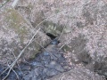
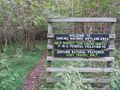
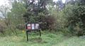
The trail consists of three connected loops. Starting from the typical access point on Cedar Branch Road is the greenish blue blazed forest or ridge loop offering some views to the south. The middle loop is the yellow blazed field loop. The final loop and location of the sinking waters namesake is the blue blazed wetlands loop. The wetlands loop is connected to the park golf course.
The trail can be made very short or long by taking the loops as desired. The description below is for an "always turn right" route starting from Cedar Branch Road, (almost always) taking the trail to the right when it splits.
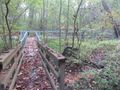
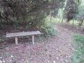
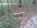
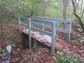
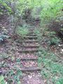
The trails are fairly well maintained with boardwalks in the wetter parts and stairs on the steeper parts. Some side trails exist without posted signs.
None needed, just park and go.
Blackberries and raspberries abound in late June and July.
At night along the boardwalk a barred owl may ask "who cooks for you, who cooks for y'all."
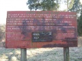
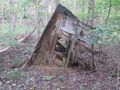
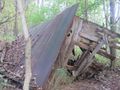
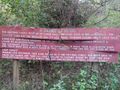
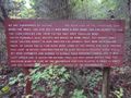
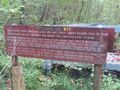
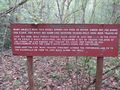
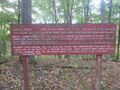
According to the signs, the Coffman family settled in the area in the late 1860's. They tried to farm, but frequent floods swept away their cornfield and peach orchard. To get by they switched to blacksmithing and built a shop in the area.
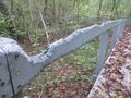
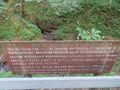
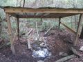
In recent times the land was owned by (?) who bought it for his daughters to have a spot to ride horses. In (?) he donated to the park.