Sill Branch: Difference between revisions
(change picture caption) |
(highlight falls) |
||
| (14 intermediate revisions by 2 users not shown) | |||
| Line 1: | Line 1: | ||
{{Trail | |||
{{ | |Banner Image=File:Sill Branch Falls.jpg | ||
|Trail Highlight=An easy short trail to a remote and beautiful waterfall | |||
|Trail Number=FS #115 | |||
|Park=Clarks Creek | |||
|Land Owner=Cherokee National Forest | |||
|Trail Marking=Blue Diamond | |||
|Trail Use=Hiking, Camping, Hunting | |||
|Trail Features=Waterfalls | |||
|Difficulty Rating=Easy | |||
|Hike Time=1 hr | |||
|Trail Distance=0.56 mi | |||
|Round Trip Distance=1.12 mi | |||
|Trail Type=In-and-Out | |||
|High Point=2,054 ft | |||
|Low Point=1,760 ft | |||
|Elevation Gain=272 ft | |||
|Elevation Loss=0 ft | |||
|Elevation Change Direction=West-to-East | |||
|Parking location=36.12832, -82.53416 | |||
|Trailhead location=36.12832, -82.53416 | |||
}} | }} | ||
{{Trail Map}} | |||
Note: Either error in the mapping, or more likely poor reception due to the trees, the trail is shown a little too far north. The first portion of the hike will have you heading out with the branch on your left. | |||
__TOC__ | |||
== Trail Overview == | == Trail Overview == | ||
Located in [[Clarks Creek]]. Forest Service Trail #115. It's a great introductory hike for those who don't like hiking, small kids, can't hike far, or just getting started. The hike is short along a very remote setting with a great payoff at the end. | |||
Located in [[Clarks Creek | |||
== How to get there == | == How to get there == | ||
<!-- Please enter detailed instruction on how to find the trail head. --> | <!-- Please enter detailed instruction on how to find the trail head. --> | ||
From the end of the paved portion of Clarks Creek Road continue 1.7 miles (total of 3.1 since leaving TN107) trail head on your left, parking on your right. | From the end of the paved portion of Clarks Creek Road continue 1.7 miles (total of 3.1 since leaving TN107) trail head on your left, parking for 4-6 vehickles on your right. | ||
== Route Description== | == Route Description== | ||
<!-- Detailed description of the route. Is there any side trails that are worth traveling? --> | <!-- Detailed description of the route. Is there any side trails that are worth traveling? --> | ||
Short hike, mostly uphill to the falls. At the junction of two blue blazed trails, stay to the LEFT to see the falls and cross the creek. | Short hike, mostly uphill to the falls. At the junction of two blue blazed trails, stay to the LEFT to see the falls and cross the creek. Someone has attached blue diamonds over the blue blazes. | ||
== Typical Conditions == | == Typical Conditions == | ||
<!-- Typical conditions throughout the year of what to expect on the trail. Rocky, muddy, sandy, flowers, lots of downed trees? --> | <!-- Typical conditions throughout the year of what to expect on the trail. Rocky, muddy, sandy, flowers, lots of downed trees? --> | ||
Fairly well worn path with some rocks. Great hike for those new to hiking. It feels remote, fairly easy, short, and a great payoff at the end for the falls. The one stream crossing has flat rocks nicely positioned for a dry crossing. | Fairly well worn path with some rocks. Great hike for those new to hiking. It feels remote, fairly easy, short, and a great payoff at the end for the falls. The one stream crossing has flat rocks nicely positioned for a dry crossing. Just over the creek is a steep, short climb. | ||
==Fees, Permits, etc. == | ==Fees, Permits, etc. == | ||
<!-- Please list any Fees, Permits, Regulations, etc. that may be required on this trail.--> | <!-- Please list any Fees, Permits, Regulations, etc. that may be required on this trail.--> | ||
No fee required. | No fee required. | ||
No AT&T cell phone service. | |||
== Photos == | == Photos == | ||
{{Park trail gallery|Trail={{PAGENAME}}}} | |||
{{Map Marker | |||
|Icon Type=Parking | |||
|Marker Title=Trailhead and parking | |||
|Marker Location=36.1283167,-82.5341583 | |||
}} | |||
{{Map Marker | |||
|Icon Type=Trail sign | |||
|Marker Title=Trail split | |||
|Marker Description=Stay to the LEFT to stay along North Fork Sill Branch and shortly after the falls | |||
|Marker Location=36.1250167,-82.5290222 | |||
}} | |||
{{Map Marker | |||
|Icon Type=Water crossing | |||
|Marker Title=Stream Crossing | |||
|Marker Location=36.125237,-82.528678 | |||
}} | |||
{{Map Marker | |||
|Icon Type=Waterfall | |||
|Marker Title=Sill Branch Falls | |||
|Marker Location=36.1247889,-82.5272722 | |||
}} | |||
Latest revision as of 11:01, 19 September 2021
| Sill Branch (log in to submit report) | |
|---|---|

| |
| Highlight | An easy short trail to a remote and beautiful waterfall |
| Trail Number | FS #115 |
| Park | Clarks Creek |
| Land Owner | Cherokee National Forest |
| Located | Erwin, TennesseeLocation inherited from associated park |
| Trail Marking | Blue Diamond |
| Trail UseThings allowed to do on or near the trail |
|
| FeaturesThings to see on or near the trail |
|
| Difficulty Rating | Easy |
| Hiking TimeTime from car and back. Includes any time hiking to access this trail. | 1 hr0.0625 Days <br />60 Min <br /> round trip |
| Distance: | 0.56 mi0.901 km <br /> trailStrict non-repeating trail length / 1.12 mi1.802 km <br /> round tripTypical or shortest length from the car, hike the trail, and return to car |
| Trail Type | In-and-Out |
| Low / High Point | 1,760 ft586.667 Yards <br />536.448 Meters <br /> / 2,054 ft684.667 Yards <br />626.059 Meters <br /> |
| Elev. Gain/LossSee link for details of calculation. Gain/Loss is direction dependent. | 272 ft82.906 Meters <br /> / (0 ft0 Meters <br />) – West-to-East |
| Trip ReportsFrom user "hiked it" submissions<br />Recent is within last 90 days | 2 logged hikes (0 recent) |
| NearbyWithin 5 mi<br />Click link to view list | 2 trails / 11.9 mi of trail |
| Parking | 36° 7' 41.95" N, 82° 32' 2.98" W Map |
| Trailhead | 36° 7' 41.95" N, 82° 32' 2.98" W Map |
|
| |
| Show In Google Maps | |
Download KML / Upload new version / KML File Page / Create Profile Chart / gpsvisualizer Map
Note: Either error in the mapping, or more likely poor reception due to the trees, the trail is shown a little too far north. The first portion of the hike will have you heading out with the branch on your left.
Trail Overview[edit]
Located in Clarks Creek. Forest Service Trail #115. It's a great introductory hike for those who don't like hiking, small kids, can't hike far, or just getting started. The hike is short along a very remote setting with a great payoff at the end.
How to get there[edit]
From the end of the paved portion of Clarks Creek Road continue 1.7 miles (total of 3.1 since leaving TN107) trail head on your left, parking for 4-6 vehickles on your right.
Route Description[edit]
Short hike, mostly uphill to the falls. At the junction of two blue blazed trails, stay to the LEFT to see the falls and cross the creek. Someone has attached blue diamonds over the blue blazes.
Typical Conditions[edit]
Fairly well worn path with some rocks. Great hike for those new to hiking. It feels remote, fairly easy, short, and a great payoff at the end for the falls. The one stream crossing has flat rocks nicely positioned for a dry crossing. Just over the creek is a steep, short climb.
Fees, Permits, etc.[edit]
No fee required. No AT&T cell phone service.
Photos[edit]
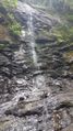
View of Sill Branch Falls
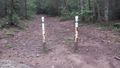
View of Sill and South Branch Trail Head

Trail Profile
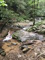
stream view along trail


