Clarks Creek
| Clarks Creek | |
|---|---|

| |
| Park Type | Recreation Area |
| Located | Erwin, Tennessee |
| External Links | |
| Entrance Fee | None |
| ActivitiesThings to do at the park | |
| Park AmenitiesThings built to enjoy or use at the park | |
| FeaturesNatural things to see at the park | |
| Park Trails |
4 Trails / Total of 6.35 miles10.219 km <br /> |
| Lodging Types | None |
| Park Area | |
| Operated By | Cherokee National Forest |
| Main Location | 36° 8' 57.41" N, 82° 31' 42.67" W Map |
|
| |
| Show In Google Maps | |
Park Overview[edit]
Clarks Creek forest (no longer classified as a USFS Recreation Area) is a secretive backcountry cove nestled in the Bald Mountains not far from the Tri-Cities, Jonesborough, and Erwin just off of TN 107. Much of the Clarks Creek area borders Sampson Mountain Wilderness. It is popular for hiking and fishing. It is home to several waterfalls, one being the famous Buckeye Falls (475'), the tallest waterfall system in Tennessee. As of 2015, camping is not allowed due to bear activity.
Directions[edit]
- Travel I-26 toward Erwin.
- Take Exit 37 and follow TN 107 West/TN 81 North
- Turn left at Lamar Crossroads to continue on TN 107.
- Travel about 5 miles and take a left onto Clarks Creek Road.
- Travel on Clarks Creek Road for about 1.5 miles to where the road turns gravel to enter the Clarks Creek Area (USFS 25; also entering Unicoi County).
History[edit]
The area was once a popular backcountry recreation area with the ruins of an old iron furnace. But due to heavy rains and flooding in the early 2000s, much of the USFS 25 road system was washed out. However, the US Forest Service has been able to rehab most of the area. Unfortunately, in 2015, a closure notice was issued for camping due to aggressive bear activity.
Buckeye Falls[edit]
Officially, Buckeye Falls is measured at 475 feet being the tallest waterfall system in Tennessee. However, many locals swear it falls more than 600 feet if counting countless cascades; unofficially beating Whitewater Falls in North Carolina as the tallest waterfall east of the Rockies. However, the 600 foot ruling has not been officially confirmed due to the steep/sheer drop terrain.
There is no longer an officially recognized Clarks Creek Trail to Buckeye Falls. The former difficult hike required a 3.6-3.8 mile trek through water fords and rocks. For the Tennessee Eastman Hiking & Canoeing Club, the hike was reported to be our first, but will not be pursued during the 75th Anniversary in 2021.
Park Trails[edit]
The park offers the following trails to explore:
| Park Trails | Distance | Difficulty | Marking | Usage | Highlight |
|---|---|---|---|---|---|
| Longarm Branch | 3.60 mi | Medium | Yellow |
|
Small cascading falls just past fourth crossing of Longarm Branch |
| Sill Branch | 0.56 mi | Easy | Blue Diamond |
|
An easy short trail to a remote and beautiful waterfall |
| Sill Branch South | 1.39 mi | Medium | Blue |
|
Forest Service Trail #116 |
| Hell HollowThis trail is a "stub" either because of its short length, lack of significance, or the page hasn't been created yet. The page can be created, but then delete the stub reference from this park. | 0.80 mi | Medium | Forest Service Trail #124 |
USFS has delisted:
- Iron Furnace Trail (FS #109) which was observed to be an overgrown, washed out narrow path leading up drainage to no scenic feature
- Clarks Creek Trail (no FS number) which did not have sufficient public use to justify its maintenance
Gallery[edit]
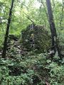
historic iron furnace
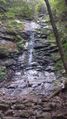
View of Sill Branch Falls
