Ridge Top (Roan Mountain State Park): Difference between revisions
Jump to navigation
Jump to search
(Add photos) |
(convert to new trail form template) |
||
| Line 1: | Line 1: | ||
{{Trail | |||
|Banner Image= | |||
|Park=Roan Mountain State Park | |||
|Trail Marking=Yellow | |||
|Trail Use=Hiking | |||
|Trail Features=Vistas, Mountains | |||
|Difficulty Rating=Medium | |||
|Hike Time=1.5 hrs | |||
|Trail Distance=2.193 mi | |||
|Round Trip Distance=4.4 mi | |||
|Trail Type=In-and-Out | |||
|High Point=3,773 ft | |||
|Low Point=2,841 ft | |||
|Elevation Gain=319 ft | |||
|Elevation Loss=1,162 ft | |||
|Elevation Change Direction=West-to-East | |||
|Parking location=36.167866,-82.096965 | |||
|Trailhead location=36.167416,-82.098804 | |||
}} | |||
{{Trail Map|Other Trails=Blue 2}} | |||
__TOC__ | |||
== Trail Overview == | == Trail Overview == | ||
This is part of the [[Roan Mountain State Park]] trail system and along with [[Blue 2]] constitutes the Mountain Bike Trails of Roan Mountain State Park | This is part of the [[Roan Mountain State Park]] trail system and along with [[Blue 2]] constitutes the Mountain Bike Trails of Roan Mountain State Park | ||
| Line 54: | Line 35: | ||
== Route Description== | == Route Description== | ||
[[File:Ridge top profile.png|thumb|right]] | |||
A short alternate option of riding around the mountain bike trails. | A short alternate option of riding around the mountain bike trails. | ||
| Line 62: | Line 43: | ||
<!-- Typical conditions throughout the year of what to expect on the trail. Rocky, muddy, sandy, flowers, lots of downed trees? --> | <!-- Typical conditions throughout the year of what to expect on the trail. Rocky, muddy, sandy, flowers, lots of downed trees? --> | ||
The trails are fairly well maintained and blazed fairly clearly with the exception of the Ridge Top connector. As I now recall, it may have been blazed blue as well. | The trails are fairly well maintained and blazed fairly clearly with the exception of the Ridge Top connector. As I now recall, it may have been blazed blue as well. | ||
== Photos == | == Photos == | ||
{{Park trail gallery|Trail={{PAGENAME}}}} | |||
Revision as of 10:39, 28 December 2019
| Ridge Top (Roan Mountain State Park) (log in to submit report) | |
|---|---|
| Park | Roan Mountain State Park |
| Located | Roan Mountain, TennesseeLocation inherited from associated park |
| Trail Marking | Yellow |
| Trail UseThings allowed to do on or near the trail |
|
| FeaturesThings to see on or near the trail |
|
| Difficulty Rating | Medium |
| Hiking TimeTime from car and back. Includes any time hiking to access this trail. | 1.5 hrs0.0938 Days <br />90 Min <br /> round trip |
| Distance: | 2.193 mi3.529 km <br /> trailStrict non-repeating trail length / 4.4 mi7.081 km <br /> round tripTypical or shortest length from the car, hike the trail, and return to car |
| Trail Type | In-and-Out |
| Low / High Point | 2,841 ft947 Yards <br />865.937 Meters <br /> / 3,773 ft1,257.667 Yards <br />1,150.01 Meters <br /> |
| Elev. Gain/LossSee link for details of calculation. Gain/Loss is direction dependent. | 319 ft97.231 Meters <br /> / (1,162 ft354.178 Meters <br />) – West-to-East |
| Trip ReportsFrom user "hiked it" submissions<br />Recent is within last 90 days | No hikes logged yet |
| NearbyWithin 5 mi<br />Click link to view list | 13 trails / 50.7 mi of trail |
| Parking | 36° 10' 4.32" N, 82° 5' 49.07" W Map |
| Trailhead | 36° 10' 2.70" N, 82° 5' 55.69" W Map |
|
| |
| Show In Google Maps | |
Download KML / Upload new version / KML File Page / Create Profile Chart / gpsvisualizer Map
Trail Overview
This is part of the Roan Mountain State Park trail system and along with Blue 2 constitutes the Mountain Bike Trails of Roan Mountain State Park
How to get there
From Johnson City (I-26 Exit 24):
- Take TN67/US321 over to Elizabethton (about eight miles).
- Turn right/south at traffic light for TN37/US19E/US321 and travel for 17 miles.
- Turn right/south for TN143 for five miles to park visitors center.
- Trailheads are in several places around the park.
GPS address is 1015 Hwy 143 Roan Mountain, TN 37687.
Route Description

A short alternate option of riding around the mountain bike trails.
Accessible from this trail is Blue 2.
Typical Conditions
The trails are fairly well maintained and blazed fairly clearly with the exception of the Ridge Top connector. As I now recall, it may have been blazed blue as well.
Photos
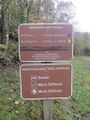
Trail head sign
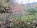
View along trail
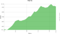
Trail Profile


_Banner.jpg)