Take either Indian Pipes Trail from near Fire Tower or Back Hollow Road.
Mountain biking is not allowed in the eastern drop down to Back Hollow Road. The western slope is inaccessible.
Nice hard dirt path up on the ridge. Eastern section was redug after a major winter storm in the 90s. The western section has been abandoned by the park after 2009 winter storms with many, many blowdowns and missing blazes, thus no maintenance being done.
Brown is Pretty Ridge Trail. Yellow is Kiner Hollow Trail. Red is Indian Pipes Trail. Green is Back Hollow Road.
Loading map...
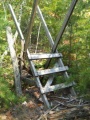
{"type":"TERRAIN","minzoom":false,"maxzoom":false,"types":["ROADMAP","SATELLITE","HYBRID","TERRAIN"],"mappingservice":"googlemaps3","width":"auto","height":"550px","centre":{"text":"","title":"","link":"","lat":36.494900000000001227817847393453121185302734375,"lon":-82.650000000000005684341886080801486968994140625,"icon":""},"title":"","label":"","icon":"","lines":[],"polygons":[],"circles":[],"rectangles":[],"copycoords":false,"static":false,"visitedicon":"","wmsoverlay":false,"zoom":15,"layers":[],"controls":["pan","zoom","type","scale","streetview","rotate"],"zoomstyle":"DEFAULT","typestyle":"DEFAULT","autoinfowindows":false,"resizable":false,"kmlrezoom":false,"poi":true,"cluster":false,"clustergridsize":60,"clustermaxzoom":20,"clusterzoomonclick":true,"clusteraveragecenter":true,"clusterminsize":2,"imageoverlays":[],"kml":[],"gkml":["http://tehcc.org/clubwiki/kml/BMP_Back_Hollow_Road.kml","http://tehcc.org/clubwiki/kml/BMP_Kiner_Hollow_Trail.kml","http://tehcc.org/clubwiki/kml/BMP_Pretty_Ridge_Trail.kml","http://tehcc.org/clubwiki/kml/BMP_Indian_Pipes_Trail.kml"],"searchmarkers":"","fullscreen":false,"scrollwheelzoom":false,"locations":[{"text":"\u003Cdiv class=\"mw-parser-output\"\u003E\u003Cp\u003EWestern descent from ridge\n\u003C/p\u003E\u003C/div\u003E","title":"Western descent from ridge\n","link":"","lat":36.4915739999999999554347596131265163421630859375,"lon":-82.657148000000006504706107079982757568359375,"icon":"/clubwiki/images/MarkerG.png"},{"text":"\u003Cdiv class=\"mw-parser-output\"\u003E\u003Cp\u003EIntersection at \u003Ca href=\"/wiki/Back_Hollow_Road\" title=\"Back Hollow Road\"\u003EBack Hollow Road\u003C/a\u003E\n\u003C/p\u003E\u003C/div\u003E","title":"Intersection at Back Hollow Road\n","link":"","lat":36.49759999999999848796505830250680446624755859375,"lon":-82.6432999999999964302332955412566661834716796875,"icon":"/clubwiki/images/MarkerT.png"},{"text":"\u003Cb\u003E\u003Cdiv class=\"mw-parser-output\"\u003E\u003Cp\u003ESty across fence\n\u003C/p\u003E\u003C/div\u003E\u003C/b\u003E\u003Cdiv class=\"mw-parser-output\"\u003E\u003Cp\u003E\u003Ca href=\"/wiki/File:BMP_Pretty_Ridge_Trail_sty.JPG\" class=\"image\"\u003E\u003Cimg alt=\"BMP Pretty Ridge Trail sty.JPG\" src=\"/clubwiki/images/thumb/BMP_Pretty_Ridge_Trail_sty.JPG/150px-BMP_Pretty_Ridge_Trail_sty.JPG\" decoding=\"async\" width=\"150\" height=\"200\" srcset=\"/clubwiki/images/thumb/BMP_Pretty_Ridge_Trail_sty.JPG/225px-BMP_Pretty_Ridge_Trail_sty.JPG 1.5x, /clubwiki/images/thumb/BMP_Pretty_Ridge_Trail_sty.JPG/300px-BMP_Pretty_Ridge_Trail_sty.JPG 2x\" data-file-width=\"336\" data-file-height=\"448\" /\u003E\u003C/a\u003E\n\u003C/p\u003E\u003C/div\u003E","title":"Sty across fence\n","link":"","lat":36.48915000000000219415596802718937397003173828125,"lon":-82.65420000000000300133251585066318511962890625,"icon":"/clubwiki/images/MarkerG.png"},{"text":"\u003Cdiv class=\"mw-parser-output\"\u003E\u003Cp\u003EIntersection at \u003Ca href=\"/wiki/Back_Hollow_Road\" title=\"Back Hollow Road\"\u003EBack Hollow Road\u003C/a\u003E\n\u003C/p\u003E\u003C/div\u003E","title":"Intersection at Back Hollow Road\n","link":"","lat":36.48818200000000189220372703857719898223876953125,"lon":-82.6537770000000051595634431578218936920166015625,"icon":"/clubwiki/images/MarkerT.png"}]}