Pretty Ridge Trail: Difference between revisions
(→Maps: add other trail head) |
(Cleaning up) |
||
| Line 2: | Line 2: | ||
{{Infobox Trail | {{Infobox Trail | ||
| Image Name = BMP Pretty Ridge Trail sty.JPG | | Image Name = BMP Pretty Ridge Trail sty.JPG | ||
| Trail Number = | |||
| Park = Bays Mountain Park | | Park = Bays Mountain Park | ||
| City = Kingsport | | City = Kingsport | ||
| Line 9: | Line 10: | ||
| Difficulty Rating = Hard | | Difficulty Rating = Hard | ||
| Hike Time = 1.5 Hours | | Hike Time = 1.5 Hours | ||
| Round Trip Distance = | | Round Trip Distance = 7.2 Mi | ||
| Trail Distance = 1.75 Mi | | Trail Distance = 1.75 Mi | ||
| Trail Type = Segment | | Trail Type = Segment | ||
| Line 23: | Line 24: | ||
== Trail Overview == | == Trail Overview == | ||
<!-- Enter a overview of the trail. What attracts you to this trail, points of interest, types of flowers, lakes, and peaks that you see along the way. --> | <!-- Enter a overview of the trail. What attracts you to this trail, points of interest, types of flowers, lakes, and peaks that you see along the way. --> | ||
Located in [[Bays Mountain Park]]. Pretty Ridge, up on the ridge, is a nice extension of [[ | Located in [[Bays Mountain Park]]. Pretty Ridge, up on the ridge, is a nice extension of [[Indian Pipes Trail|Indian Pipes Trail]], but difficult hiking between [[Back Hollow Road|Back Hollow Road]]. | ||
== How to get there == | == How to get there == | ||
<!-- Please enter detailed instruction on how to find the trail head. --> | <!-- Please enter detailed instruction on how to find the trail head. --> | ||
Take either Indian Pipes Trail from near | Take either Indian Pipes Trail from near Fire Tower or Back Hollow Road. | ||
== Route Description== | == Route Description== | ||
<!-- Detailed description of the route. Is there any side trails that are worth traveling? --> | <!-- Detailed description of the route. Is there any side trails that are worth traveling? --> | ||
On paper, a U-shaped path up from Back Hollow Road, along the ridgeline, and back down. The western segment has been abandoned by the park at this time. | On paper, a U-shaped path up from Back Hollow Road, along the ridgeline, and back down with connections to [[Trail connects to::Back Hollow Road]], [[Trail connects to::Cross Ridges Trail]], [[Trail connects to::Indian Pipes Trail]], [[Trail connects to::Kiner Hollow Trail]], [[Trail connects to::Front Hollow Road]], and [[Trail connects to::Bays Ridge Trail]]. The western segment has been abandoned by the park at this time. The trail is marked with white plastic blazes. | ||
{| class="wikitable" border="1" | {| class="wikitable" border="1" | ||
| Line 44: | Line 45: | ||
|- | |- | ||
|0.45 | |0.45 | ||
|Intersection with [[ | |Intersection with [[Indian Pipes Trail|Indian Pipes Trail]] and [[Kiner Hollow Trail]] | ||
|1980 | |1980 | ||
|- | |- | ||
| Line 80: | Line 81: | ||
36.491574,-82.657148~Western descent from ridge~ ~MarkerG.png | 36.491574,-82.657148~Western descent from ridge~ ~MarkerG.png | ||
36.4976,-82.6433~Intersection at [[ | 36.4976,-82.6433~Intersection at [[Back Hollow Road|Back Hollow Road]]~ ~MarkerT.png | ||
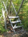
36.48915,-82.65420~Sty across fence~[[Image:BMP_Pretty_Ridge_Trail_sty.JPG|150px]]~MarkerG.png | 36.48915,-82.65420~Sty across fence~[[Image:BMP_Pretty_Ridge_Trail_sty.JPG|150px]]~MarkerG.png | ||
36.488182,-82.653777~Intersection at [[ | 36.488182,-82.653777~Intersection at [[Back Hollow Road|Back Hollow Road]]~ ~MarkerT.png | ||
</display_map> | </display_map> | ||
| Line 94: | Line 95: | ||
<!-- Finally add the trail to any Categories it should belong to. --> | <!-- Finally add the trail to any Categories it should belong to. --> | ||
[[Category:Tennessee]] [[Category:Kingsport]] [[Category:Bays Mountain Park]] [[Category:Hard]] [[Category:Hiking]] [[Category:Biking]] [[Category:Dog Friendly]] | [[Category:Tennessee]] [[Category:Kingsport]] [[Category:Bays Mountain Park]] [[Category:Hard]] [[Category:Hiking]] [[Category:Biking]] [[Category:Dog Friendly]] | ||
{{#set: | |||
|Trail page needs=Detail route description;Photos;Trail pins;Update 1|+sep=; | |||
}} | |||
Revision as of 22:16, 6 October 2015
| |||||||||||||||||||||||||||||||||||||||||||||

Trail Overview
Located in Bays Mountain Park. Pretty Ridge, up on the ridge, is a nice extension of Indian Pipes Trail, but difficult hiking between Back Hollow Road.
How to get there
Take either Indian Pipes Trail from near Fire Tower or Back Hollow Road.
Route Description
On paper, a U-shaped path up from Back Hollow Road, along the ridgeline, and back down with connections to Back Hollow Road, Cross Ridges Trail, Indian Pipes Trail, Kiner Hollow Trail, Front Hollow Road, and Bays Ridge Trail. The western segment has been abandoned by the park at this time. The trail is marked with white plastic blazes.
| Miles | Pretty Ridge Trail | Elevation (ft) |
|---|---|---|
| 0.00 | Back Hollow Road at abandoned cabin | 1672 |
| 0.45 | Intersection with Indian Pipes Trail and Kiner Hollow Trail | 1980 |
| 1.35 | Split back down just before meeting Kiner Hollow Trail again | 2000 |
| 1.65 | Sty over fence | 1665 |
| 1.7 | Back Hollow Road at open meadows | 1615 |
Mountain biking is not allowed in the eastern drop down to Back Hollow Road. The western slope is inaccessible.
Typical Conditions
Nice hard dirt path up on the ridge. Eastern section was redug after a major winter storm in the 90s. The western section has been abandoned by the park after 2009 winter storms with many, many blowdowns and missing blazes, thus no maintenance being done.
Misc. Information
Maps
Brown is Pretty Ridge Trail. Yellow is Kiner Hollow Trail. Red is Indian Pipes Trail. Green is Back Hollow Road.
Photos
Sty across fence - key location