|
|
| Line 1: |
Line 1: |
| <!-- The following few lines create the "Infobox" table template. Please scroll down to edit the main content of the article. --> | | <!-- The following few lines create the "Infobox" table template. Please scroll down to edit the main content of the article. --> |
| {{Infobox Trail | | {{Infobox Trail |
| | Image Name = BMP Pretty Ridge Trail sty.JPG
| | | Image Name = BMP Pretty Ridge Trail sty.JPG |
| | City = Kingsport
| | | Park = Bays Mountain Park |
| | State = Tennessee
| | | City = Kingsport |
| | Marking = Junction Signs
| | | State = Tennessee |
| | Trail Use = {{Hike}} {{Biking}} {{Dogs}}
| | | Marking = Signs |
| | Difficulty Rating = Hard
| | | Trail Use = {{Hike}} {{Biking}} {{Dogs}} |
| | Hike Time = 1.5
| | | Difficulty Rating = Hard |
| | Distance = 1.7
| | | Hike Time = 1.5 Hours |
| | Elevation Gain = ~470
| | | Round Trip Distance = 3.5 Mi |
| | High Point = 2081
| | | Trail Distance = 1.75 Mi |
| | Latitude = 36.49487
| | | Trail Type = Segment |
| | Longitude = -82.60517
| | | Elevation Gain = 668 Ft |
| | Medical = Kingsport, TN
| | | Elevation Loss = -769 Ft |
| | | High Point = 2,154 Ft |
| | | Parking coords = 36.508821,-82.609545 |
| | | Trailhead coords = 36.497640,-82.643300 |
| | | Medical = Kingsport, TN |
| }} | | }} |
| <!-- End Infobox template table--> | | <!-- End Infobox template table--> |
|
| |
| <!-- Start of Main Page --> | | <!-- Start of Main Page --> |
|
| |
| == Trail Overview == | | == Trail Overview == |
| <!-- Enter a overview of the trail. What attracts you to this trail, points of interest, types of flowers, lakes, and peaks that you see along the way. --> | | <!-- Enter a overview of the trail. What attracts you to this trail, points of interest, types of flowers, lakes, and peaks that you see along the way. --> |
| Line 72: |
Line 74: |
| Brown is Pretty Ridge Trail. Yellow is Kiner Hollow Trail. Red is Indian Pipes Trail. Green is Back Hollow Road. | | Brown is Pretty Ridge Trail. Yellow is Kiner Hollow Trail. Red is Indian Pipes Trail. Green is Back Hollow Road. |
|
| |
|
| <googlemap version="0.9" lat="36.4949" lon="-82.65" type="terrain" zoom="15" width="725" scale="yes" icons="http://tehcc.org/clubwiki/kml/marker{label}.png"> | | <display_map center="36.4949,-82.65" type="terrain" zoom="15" width="auto" height="550" gkml="http://tehcc.org/clubwiki/kml/BMP_Back_Hollow_Road.kml, |
| http://tehcc.org/clubwiki/kml/BMP_Back_Hollow_Road.kml | | http://tehcc.org/clubwiki/kml/BMP_Kiner_Hollow_Trail.kml, |
| http://tehcc.org/clubwiki/kml/BMP_Kiner_Hollow_Trail.kml | | http://tehcc.org/clubwiki/kml/BMP_Pretty_Ridge_Trail.kml, |
| http://tehcc.org/clubwiki/kml/BMP_Pretty_Ridge_Trail.kml | | http://tehcc.org/clubwiki/kml/BMP_Indian_Pipes_Trail.kml"> |
| http://tehcc.org/clubwiki/kml/BMP_Indian_Pipes_Trail.kml | |
|
| |
|
| (G) 36.491574,-82.657148
| | 36.491574,-82.657148~Western descent from ridge~ ~MarkerG.png |
| Western descent from ridge | | 36.4976,-82.6433~Intersection at [[BMP Back Hollow Road|Back Hollow Road]]~ ~MarkerT.png |
| (G) 36.4976,-82.6433
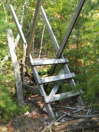
| | 36.48915,-82.65420~Sty across fence~[[Image:BMP_Pretty_Ridge_Trail_sty.JPG|150px]]~MarkerG.png |
| Intersection at [[BMP Back Hollow Road|Back Hollow Road]] | | </display_map> |
| 36.48915,-82.65420 | |
| Sty across fence | |
| [[Image:BMP_Pretty_Ridge_Trail_sty.JPG|150px]] | |
| </googlemap> | |
|
| |
|
| == Photos == | | == Photos == |
|
|
|
|
|
| Trail Name
|
Pretty Ridge Trail
|
| Park
|
Bays Mountain Park
|
| Nearest City
|
Kingsport
|
| State
|
Tennessee
|
| Trail Marking
|
Signs
|
| Trail Use/Features
|
  
|
| Difficulty Rating
|
Hard
|
| Hiking Time
|
1.5 Hours0.0938 Days <br />90 Min <br />
|
Distance:
round-trip/trail only
|
3.5 Mi5.633 km <br /> / 1.75 Mi2.816 km <br />
|
| Trail Type
|
Segment
|
| Climb/Descent Elevation
|
668 Ft203.606 Meters <br /> / -769 Ft-234.391 Meters <br />
|
| High Point
|
2,154 Ft718 Yards <br />656.539 Meters <br />
|
| Parking
|
36° 30' 31.76" N, 82° 36' 34.36" W
|
| Trailhead
|
36° 29' 51.50" N, 82° 38' 35.88" W
|
| Nearest Medical
|
Kingsport, TN
|
| Trip Reports
|
Click Here
|
|
|
Loading map... {"type":"ROADMAP","minzoom":false,"maxzoom":false,"types":["ROADMAP","SATELLITE","HYBRID","TERRAIN"],"mappingservice":"googlemaps3","width":"270px","height":"180px","centre":false,"title":"","label":"","icon":"","lines":[],"polygons":[],"circles":[],"rectangles":[],"copycoords":false,"static":false,"visitedicon":"","wmsoverlay":false,"zoom":8,"layers":[],"controls":["zoom"],"zoomstyle":"DEFAULT","typestyle":"DEFAULT","autoinfowindows":false,"resizable":false,"kmlrezoom":false,"poi":true,"cluster":false,"clustergridsize":60,"clustermaxzoom":20,"clusterzoomonclick":true,"clusteraveragecenter":true,"clusterminsize":2,"imageoverlays":[],"kml":[],"gkml":[],"searchmarkers":"","fullscreen":false,"scrollwheelzoom":false,"locations":[{"text":"","title":"","link":"","lat":36.5088209999999975252649164758622646331787109375,"lon":-82.609544999999997116901795379817485809326171875,"icon":""}]} |
|
| Show Large Map
|
|
Trail Overview
Located in Bays Mountain Park. Pretty Ridge, up on the ridge, is a nice extension of Indian Pipes Trail, but difficult hiking between Back Hollow Road.
How to get there
Take either Indian Pipes Trail from near Firetower or Back Hollow Road.
Route Description
On paper, a U-shaped path up from Back Hollow Road, along the ridgeline, and back down. The western segment has been abandoned by the park at this time. White plastic blazes.
| Miles
|
Pretty Ridge Trail
|
Elevation (ft)
|
| 0.00
|
Back Hollow Road at abandoned cabin
|
1672
|
| 0.45
|
Intersection with Indian Pipes Trail and Kiner Hollow Trail
|
1980
|
| 1.35
|
Split back down just before meeting Kiner Hollow Trail again
|
2000
|
| 1.65
|
Sty over fence
|
1665
|
| 1.7
|
Back Hollow Road at open meadows
|
1615
|
Mountain biking is not allowed in the eastern drop down to Back Hollow Road. The western slope is inaccessible.
Typical Conditions
Nice hard dirt path up on the ridge. Eastern section was redug after a major winter storm in the 90s. The western section has been abandoned by the park after 2009 winter storms with many, many blowdowns and missing blazes, thus no maintenance being done.
Misc. Information
Maps
Brown is Pretty Ridge Trail. Yellow is Kiner Hollow Trail. Red is Indian Pipes Trail. Green is Back Hollow Road.
Loading map...
{"type":"TERRAIN","minzoom":false,"maxzoom":false,"types":["ROADMAP","SATELLITE","HYBRID","TERRAIN"],"mappingservice":"googlemaps3","width":"auto","height":"550px","centre":{"text":"","title":"","link":"","lat":36.494900000000001227817847393453121185302734375,"lon":-82.650000000000005684341886080801486968994140625,"icon":""},"title":"","label":"","icon":"","lines":[],"polygons":[],"circles":[],"rectangles":[],"copycoords":false,"static":false,"visitedicon":"","wmsoverlay":false,"zoom":15,"layers":[],"controls":["pan","zoom","type","scale","streetview","rotate"],"zoomstyle":"DEFAULT","typestyle":"DEFAULT","autoinfowindows":false,"resizable":false,"kmlrezoom":false,"poi":true,"cluster":false,"clustergridsize":60,"clustermaxzoom":20,"clusterzoomonclick":true,"clusteraveragecenter":true,"clusterminsize":2,"imageoverlays":[],"kml":[],"gkml":["http://tehcc.org/clubwiki/kml/BMP_Back_Hollow_Road.kml","http://tehcc.org/clubwiki/kml/BMP_Kiner_Hollow_Trail.kml","http://tehcc.org/clubwiki/kml/BMP_Pretty_Ridge_Trail.kml","http://tehcc.org/clubwiki/kml/BMP_Indian_Pipes_Trail.kml"],"searchmarkers":"","fullscreen":false,"scrollwheelzoom":false,"locations":[{"text":"\u003Cdiv class=\"mw-parser-output\"\u003E\u003Cp\u003EWestern descent from ridge\n\u003C/p\u003E\u003C/div\u003E","title":"Western descent from ridge\n","link":"","lat":36.4915739999999999554347596131265163421630859375,"lon":-82.657148000000006504706107079982757568359375,"icon":"/clubwiki/images/MarkerG.png"},{"text":"\u003Cdiv class=\"mw-parser-output\"\u003E\u003Cp\u003EIntersection at \u003Ca href=\"/wiki/BMP_Back_Hollow_Road\" class=\"mw-redirect\" title=\"BMP Back Hollow Road\"\u003EBack Hollow Road\u003C/a\u003E\n\u003C/p\u003E\u003C/div\u003E","title":"Intersection at Back Hollow Road\n","link":"","lat":36.49759999999999848796505830250680446624755859375,"lon":-82.6432999999999964302332955412566661834716796875,"icon":"/clubwiki/images/MarkerT.png"},{"text":"\u003Cb\u003E\u003Cdiv class=\"mw-parser-output\"\u003E\u003Cp\u003ESty across fence\n\u003C/p\u003E\u003C/div\u003E\u003C/b\u003E\u003Cdiv class=\"mw-parser-output\"\u003E\u003Cp\u003E\u003Ca href=\"/wiki/File:BMP_Pretty_Ridge_Trail_sty.JPG\" class=\"image\"\u003E\u003Cimg alt=\"BMP Pretty Ridge Trail sty.JPG\" src=\"/clubwiki/images/thumb/BMP_Pretty_Ridge_Trail_sty.JPG/150px-BMP_Pretty_Ridge_Trail_sty.JPG\" decoding=\"async\" width=\"150\" height=\"200\" srcset=\"/clubwiki/images/thumb/BMP_Pretty_Ridge_Trail_sty.JPG/225px-BMP_Pretty_Ridge_Trail_sty.JPG 1.5x, /clubwiki/images/thumb/BMP_Pretty_Ridge_Trail_sty.JPG/300px-BMP_Pretty_Ridge_Trail_sty.JPG 2x\" data-file-width=\"336\" data-file-height=\"448\" /\u003E\u003C/a\u003E\n\u003C/p\u003E\u003C/div\u003E","title":"Sty across fence\n","link":"","lat":36.48915000000000219415596802718937397003173828125,"lon":-82.65420000000000300133251585066318511962890625,"icon":"/clubwiki/images/MarkerG.png"}]}
Photos
Sty across fence - key location

