Phipps Bend Trail
| |||||||||||||||||||||||||||||||||||||
Trail Overview
In-and-out hike along a level old gravel road around the bend in Holston River at Phipps Bend Industrial Park. Opportunity to see various waterfowl due to the adjacent wetlands and river.
How to get there
From Kingsport, TN
- Take Highway 11W west.
- Turn south on Phipps Bend Road.
- At the Cooper Standard business, turn left/east onto unnamed road. This is the left after Technology Drive.
- Reach parking area at coordinates. The trail past locked gate heads east along gravel roadway.
Route Description
An in-and-out hike along an old gravel road - roughly five miles round trip with very limited elevation change. Path is also used by trail runners, mountain bikes, and horses. Ends at farmer's field.
Typical Conditions
Hard packed gravel - shared with bikes, so be alert. Edged by wetlands and Holston River with lots of wildlife to observe.
An Eagle Scout project provided a trailhead sign and distance markers as orange topped posts.
Fees, Permits, etc.
No fee. Opens 30 minutes before sunrise and closes 30 minutes after sunset.
After the Hike
Phipps Bend was to be a nuclear power plant site. There are couple of large "ruins" left behind to see.
Misc. Information
Avoid this location during last weekend in March as there is a trail race held here!
Maps
<googlemap version="0.9" lat="36.468" lon="-82.809" type="terrain" zoom="14" scale="yes" icons="http://tehcc.org/clubwiki/kml/marker{label}.png"> http://tehcc.org/clubwiki/kml/Phipps_Bend_Trail.kml
(A) 36.4732,-82.8059 Trailhead parking (G) 36.47378, -82.80413 Locked gate at trailhead (G) 36.46575, -82.82517 Roughly end of trail </googlemap>
Photos
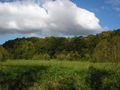
Near trail turnaround
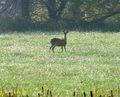
Deer

