Loading map...
{"format":"googlemaps3","type":"TERRAIN","minzoom":false,"maxzoom":false,"types":["SATELLITE","HYBRID","TERRAIN"],"limit":50,"offset":0,"link":"none","sort":[""],"order":[],"headers":"show","mainlabel":"","intro":"","outro":"","searchlabel":"... further results","default":"","import-annotation":false,"width":"auto","height":"600px","centre":false,"title":"","label":"","icon":"","lines":[],"polygons":[],"circles":[],"rectangles":[],"copycoords":false,"static":false,"visitedicon":"","wmsoverlay":false,"zoom":false,"layers":[],"controls":["pan","zoom","type","scale","streetview","rotate"],"zoomstyle":"DEFAULT","typestyle":"DEFAULT","autoinfowindows":false,"resizable":false,"kmlrezoom":true,"poi":true,"cluster":false,"clustergridsize":60,"clustermaxzoom":20,"clusterzoomonclick":true,"clusteraveragecenter":true,"clusterminsize":2,"imageoverlays":[],"kml":[],"gkml":["https://tehcc.org/clubwiki/images/Phipps_Bend_Trail.kml"],"searchmarkers":"","fullscreen":false,"scrollwheelzoom":false,"showtitle":false,"hidenamespace":true,"template":"Map Balloon Template","userparam":"","activeicon":"","pagelabel":false,"ajaxcoordproperty":"","ajaxquery":"","locations":[{"text":"\u003Cp\u003E\u003Cb\u003E\u003Ca class=\"mw-selflink selflink\"\u003EPhipps Bend Trail\u003C/a\u003E\u003C/b\u003E\u003Cbr /\u003E\u003C/p\u003E\u003Chr /\u003E\u003Cp\u003E3.00\u0026#160;Mi (4.83\u0026#160;km)\u003Cbr /\u003EDifficulty: Easy\u003Cbr /\u003EMarking: TVA Hiker Signs\u003C/p\u003E","title":"Phipps Bend Trail","link":"","lat":36.47377999999999786950866109691560268402099609375,"lon":-82.8041300000000006775735528208315372467041015625,"icon":"/clubwiki/images/MarkerT.png"},{"text":"\u003Cp\u003E\u003Cb\u003EHigh Voltage\u003C/b\u003E\u003Cbr /\u003E\u003C/p\u003E\u003Chr /\u003E\u003Cp\u003E\u003Ca href=\"/wiki/File:High_Voltage_Grounding_Mats.JPG\" class=\"image\"\u003E\u003Cimg alt=\"High Voltage Grounding Mats.JPG\" src=\"/clubwiki/images/thumb/High_Voltage_Grounding_Mats.JPG/150px-High_Voltage_Grounding_Mats.JPG\" decoding=\"async\" width=\"150\" height=\"333\" srcset=\"/clubwiki/images/thumb/High_Voltage_Grounding_Mats.JPG/225px-High_Voltage_Grounding_Mats.JPG 1.5x, /clubwiki/images/thumb/High_Voltage_Grounding_Mats.JPG/300px-High_Voltage_Grounding_Mats.JPG 2x\" data-file-width=\"506\" data-file-height=\"1125\" /\u003E\u003C/a\u003E\u003C/p\u003E","title":"Phipps Bend Trail","link":"","lat":36.45823299999999989040588843636214733123779296875,"lon":-82.801883000000003676177584566175937652587890625,"icon":"/clubwiki/images/MarkerB.png"},{"text":"\u003Cp\u003E\u003Cb\u003ETrailhead parking\u003C/b\u003E\u003Cbr /\u003E\u003C/p\u003E\u003Chr /\u003E\u003Cp\u003ETrailhead parking\u003C/p\u003E","title":"Phipps Bend Trail","link":"","lat":36.47319999999999851070242584683001041412353515625,"lon":-82.8058999999999940655470709316432476043701171875,"icon":"/clubwiki/images/MarkerA.png"},{"text":"\u003Cp\u003E\u003Cb\u003EEnd of trail\u003C/b\u003E\u003Cbr /\u003E\u003C/p\u003E\u003Chr /\u003E\u003Cp\u003E\u003Ca href=\"/wiki/File:Phipps_Bend_End_of_Trail.png\" class=\"image\"\u003E\u003Cimg alt=\"Phipps Bend End of Trail.png\" src=\"/clubwiki/images/thumb/Phipps_Bend_End_of_Trail.png/150px-Phipps_Bend_End_of_Trail.png\" decoding=\"async\" width=\"150\" height=\"113\" srcset=\"/clubwiki/images/thumb/Phipps_Bend_End_of_Trail.png/225px-Phipps_Bend_End_of_Trail.png 1.5x, /clubwiki/images/thumb/Phipps_Bend_End_of_Trail.png/300px-Phipps_Bend_End_of_Trail.png 2x\" data-file-width=\"504\" data-file-height=\"378\" /\u003E\u003C/a\u003E\u003C/p\u003E","title":"Phipps Bend Trail","link":"","lat":36.4657600000000030604496714659035205841064453125,"lon":-82.8250000000000028421709430404007434844970703125,"icon":"/clubwiki/images/MarkerG.png"},{"text":"\u003Cp\u003E\u003Cb\u003ELocked gate at trailhead\u003C/b\u003E\u003Cbr /\u003E\u003C/p\u003E\u003Chr /\u003E\u003Cp\u003ELocked gate at trailhead\u003C/p\u003E","title":"Phipps Bend Trail","link":"","lat":36.47377999999999786950866109691560268402099609375,"lon":-82.8041300000000006775735528208315372467041015625,"icon":"/clubwiki/images/MarkerG.png"},{"text":"\u003Cp\u003E\u003Cb\u003ELillypad Pond\u003C/b\u003E\u003Cbr /\u003E\u003C/p\u003E\u003Chr /\u003E\u003Cp\u003E\u003Ca href=\"/wiki/File:Phipps_Bend_Lillypad_Pond.jpg\" class=\"image\"\u003E\u003Cimg alt=\"Phipps Bend Lillypad Pond.jpg\" src=\"/clubwiki/images/thumb/Phipps_Bend_Lillypad_Pond.jpg/150px-Phipps_Bend_Lillypad_Pond.jpg\" decoding=\"async\" width=\"150\" height=\"113\" srcset=\"/clubwiki/images/thumb/Phipps_Bend_Lillypad_Pond.jpg/225px-Phipps_Bend_Lillypad_Pond.jpg 1.5x, /clubwiki/images/thumb/Phipps_Bend_Lillypad_Pond.jpg/300px-Phipps_Bend_Lillypad_Pond.jpg 2x\" data-file-width=\"4032\" data-file-height=\"3024\" /\u003E\u003C/a\u003E\u003C/p\u003E","title":"Phipps Bend Trail","link":"","lat":36.4626099999999979672793415375053882598876953125,"lon":-82.7966799999999949477569316513836383819580078125,"icon":"/clubwiki/images/MarkerB.png"}]}
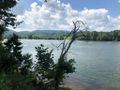
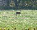
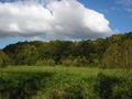
In-and-out hike along a level old gravel road around the bend in Holston River at Phipps Bend Industrial Park. Opportunity to see various waterfowl due to the adjacent wetlands and river.
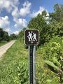
An in-and-out hike on an old gravel road along the Holston River - six miles round trip with very limited elevation change. Path is also used by trail runners, mountain bikes, and horses. Ends at farmer's field.
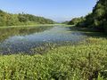
Hard packed gravel - shared with bikes and horses, so be alert. Horses keep the gravel churned up so a more rocky experience. Edged by wetlands and Holston River with lots of wildlife to observe.
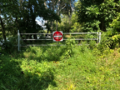
No fee. Opens 30 minutes before sunrise and closes 30 minutes after sunset.
Managed by Phipps Bend Industrial Park. In February 2020, there was construction to install a culvert to allow better control of the wetlands water level.
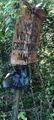
Phipps Bend was to be a nuclear power plant site. There are couple of large "ruins" left behind to see.
Avoid this location during second Saturday in October as there is a trail race held here!