|
|
| (13 intermediate revisions by 2 users not shown) |
| Line 1: |
Line 1: |
| <!-- The following few lines create the "Infobox" table template. Please scroll down to edit the main content of the article.
| | {{Trail |
| | |Banner Image=File:Phipps Bend Trail - near trail end.jpg |
| | |Trail Highlight=Hike, bike, or horseride along the Holston River near canceled nuclear power plant |
| | |City=Surgoinsville |
| | |Trail Marking=TVA Hiker Signs |
| | |Trail Use=Hiking, Biking, Geocaching, Horses, Fishing |
| | |Trail Features=Vistas, Rivers |
| | |Difficulty Rating=Easy |
| | |Hike Time=2.5 hrs |
| | |Trail Distance=3 mi |
| | |Round Trip Distance=6 mi |
| | |Trail Type=In-and-Out |
| | |High Point=1,127 ft |
| | |Low Point=1,101 ft |
| | |Elevation Gain=6 ft |
| | |Elevation Loss=0 ft |
| | |Elevation Change Direction=Counter Clockwise |
| | |Parking location=36.47378, -82.80413 |
| | |Trailhead location=36.47378, -82.80413 |
| | }} |
| | {{Trail Map}} |
|
| |
|
| -->{{Infobox Trail
| | __TOC__ |
| | Image Name = Phipps_Bend_Trail_-_near_trail_end.jpg
| |
| | City = Surgoinsville
| |
| | State = Tennesse
| |
| | Marking = Orange
| |
| | Trail Use = {{Hike}} {{Biking}} {{Horses}} {{Dogs}}
| |
| | Difficulty Rating = Easy
| |
| | Hike Time = 2.5
| |
| | Distance = 6
| |
| | Elevation Gain = 24
| |
| | High Point = 1120
| |
| | Latitude = 36.47378
| |
| | Longitude = -82.80413
| |
| | Medical = Kingsport, TN
| |
| }}<!--
| |
|
| |
|
| End Infobox template table
| |
|
| |
| -->{{Trail page needs
| |
| | Hide needs =
| |
| | KML =
| |
| | Updated KML =
| |
| | Detail route description = Yes
| |
| | Photos =
| |
| | Winter photos =
| |
| | Remove prefix =
| |
| | Update infobox = Yes
| |
| | Infobox data update = Yes
| |
| | Trail pins =
| |
| | Other =
| |
| | Comment = More detailed route description?
| |
| | Date reviewed = 11/1/2015
| |
| }}<!--
| |
|
| |
| Start of Main Page -->
| |
| == Trail Overview == | | == Trail Overview == |
| <!-- Enter an overview of the trail. What attracts you to this trail, points of interest, types of flowers, lakes, and peaks that you see along the way. -->
| |
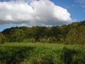
| In-and-out hike along a level old gravel road around the bend in Holston River at Phipps Bend Industrial Park. Opportunity to see various waterfowl due to the adjacent wetlands and river. | | In-and-out hike along a level old gravel road around the bend in Holston River at Phipps Bend Industrial Park. Opportunity to see various waterfowl due to the adjacent wetlands and river. |
|
| |
|
| Line 45: |
Line 31: |
| #Take Highway 11W west. | | #Take Highway 11W west. |
| #Turn south on Phipps Bend Road. | | #Turn south on Phipps Bend Road. |
| #At the Cooper Standard business, turn left/east onto unnamed road. This is the left after Technology Drive. | | #At the Cooper Standard business, turn left/east onto unmarked Schmiede Road. First left after Technology Drive. |
| #Reach parking area at coordinates. The trail past locked gate heads east along gravel roadway. | | #Reach parking area at coordinates. The trail is past locked gate heading east along gravel roadway. |
|
| |
|
| == Route Description== | | == Route Description== |
| <!-- Detailed description of the route. Are there any side trails that are worth traveling? -->
| | [[File:Phipps bend trail profile.png|thumb|right|Profile chart]] |
| An in-and-out hike along an old gravel road - roughly five miles round trip with very limited elevation change. Path is also used by trail runners, mountain bikes, and horses. Ends at farmer's field. | | An in-and-out hike on an old gravel road along the Holston River - six miles round trip with very limited elevation change. Path is also used by trail runners, mountain bikes, and horses. Ends at farmer's field. |
|
| |
|
| == Typical Conditions == | | == Typical Conditions == |
| <!-- Typical conditions throughout the year of what to expect on the trail. Rocky, muddy, sandy, flowers, lots of downed trees? --> | | <!-- Typical conditions throughout the year of what to expect on the trail. Rocky, muddy, sandy, flowers, lots of downed trees? --> |
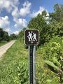
| Hard packed gravel - shared with bikes and horses, so be alert. Edged by wetlands and Holston River with lots of wildlife to observe. | | Hard packed gravel - shared with bikes and horses, so be alert. Horses keep the gravel churned up so a more rocky experience. Edged by wetlands and Holston River with lots of wildlife to observe. |
| | |
| An [http://therogersvillereview.com/story/7069 Eagle Scout project] provided a trailhead sign and distance markers as orange topped posts. These have completely faded and some are damaged.
| |
|
| |
|
| ==Fees, Permits, etc. == | | ==Fees, Permits, etc. == |
| <!-- Please list any Fees, Permits, Regulations, etc. that may be required on this trail.--> | | <!-- Please list any Fees, Permits, Regulations, etc. that may be required on this trail.--> |
| No fee. Opens 30 minutes before sunrise and closes 30 minutes after sunset. | | No fee. Opens 30 minutes before sunrise and closes 30 minutes after sunset. |
| | |
| | Managed by Phipps Bend Industrial Park. In February 2020, there was construction to install a culvert to allow better control of the wetlands water level. |
|
| |
|
| == After the Hike == | | == After the Hike == |
| Line 68: |
Line 54: |
| == Misc. Information == | | == Misc. Information == |
| <!-- Enter any additional information that doesn't fit an any other fields. --> | | <!-- Enter any additional information that doesn't fit an any other fields. --> |
| Avoid this location during last weekend in March as there is a trail race held here! | | Avoid this location during second Saturday in October as there is a trail race held here! |
| | |
| == Maps ==
| |
| <!-- You can place pictures, PDF's, links, or even create a Google map with your waypoints and place it here. -->
| |
| <display_map center="36.468,-82.809" type="terrain" zoom="14" gkml="http://tehcc.org/clubwiki/kml/Phipps_Bend_Trail.kml">
| |
| | |
| 36.4732,-82.8059~Trailhead parking~ ~MarkerA.png
| |
| 36.47378, -82.80413~Locked gate at trailhead~ ~MarkerG.png
| |
| 36.46576, -82.82500~End of trail~ ~MarkerG.png
| |
| </display_map>
| |
|
| |
|
| == Photos == | | == Photos == |
| <gallery>
| | {{Park trail gallery|Trail={{PAGENAME}}}} |
| <!-- Place any pictures from this trail below. Ideally we would have a picture of the trailhead to help people know when they found it -->
| | {{Map Marker |
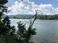
| Image:Phipps_Bend_Trail_-_near_trail_end.jpg|Near trail turnaround
| | |Icon Type=Photo spot |
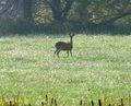
| Image:Phipps_Bend_Trail_-_deer.jpg|Deer
| | |Marker Title=Lillypad Pond |
| Image:
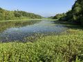
| | |Marker Description=[[File:Phipps Bend Lillypad Pond.jpg|150px]] |
| <!-- Do not remove the end gallery code.-->
| | |Marker Location=36.46261, -82.79668 |
| </gallery>
| | }} |
| | | {{Map Marker |
| <!-- Categories -->
| | |Icon Type=Photo spot |
| [[Category:Tennessee]] [[Category:Easy]] [[Category:Hiking]] [[Category:Dog Friendly]] [[Category:Horse Riding]] [[Category:Biking]] | | |Marker Title=High Voltage |
| | |Marker Description=[[File:High Voltage Grounding Mats.JPG|150px]] |
| | |Marker Location=36.458233,-82.801883 |
| | }} |
| | {{Map Marker |
| | |Icon Type=Parking |
| | |Marker Title=Trailhead parking |
| | |Marker Location=36.4732,-82.8059 |
| | }} |
| | {{Map Marker |
| | |Icon Type=Point of interest |
| | |Marker Title=Locked gate at trailhead |
| | |Marker Location=36.47378, -82.80413 |
| | }} |
| | {{Map Marker |
| | |Icon Type=Point of interest |
| | |Marker Title=End of trail |
| | |Marker Description=[[File:Phipps Bend End of Trail.png|150px]] |
| | |Marker Location=36.46576, -82.82500 |
| | }} |
| Phipps Bend Trail
(log in to submit report)
|

|
|
|
| Highlight
|
Hike, bike, or horseride along the Holston River near canceled nuclear power plant
|
| Located
|
Surgoinsville
|
| Trail Marking
|
TVA Hiker Signs
|
| Trail UseThings allowed to do on or near the trail
|
    
|
| FeaturesThings to see on or near the trail
|
 
|
| Difficulty Rating
|
Easy
|
| Hiking TimeTime from car and back. Includes any time hiking to access this trail.
|
2.5 hrs0.156 Days <br />150 Min <br /> round trip
|
| Distance:
|
3 mi4.828 km <br /> trailStrict non-repeating trail length / 6 mi9.656 km <br /> round tripTypical or shortest length from the car, hike the trail, and return to car
|
| Trail Type
|
In-and-Out
|
| Low / High Point
|
1,101 ft367 Yards <br />335.585 Meters <br /> / 1,127 ft375.667 Yards <br />343.51 Meters <br />
|
| Elev. Gain/LossSee link for details of calculation. Gain/Loss is direction dependent.
|
6 ft1.829 Meters <br /> / (0 ft0 Meters <br />) – Counter Clockwise
|
| Trip ReportsFrom user "hiked it" submissions<br />Recent is within last 90 days
|
1 logged hikes (0 recent)
|
| NearbyWithin 5 mi<br />Click link to view list
|
No other Trails within 5 mi
|
| Parking
|
36° 28' 25.61" N, 82° 48' 14.87" W Map
|
| Trailhead
|
36° 28' 25.61" N, 82° 48' 14.87" W Map
|
Loading map... {"type":"ROADMAP","minzoom":false,"maxzoom":false,"types":["ROADMAP","SATELLITE","HYBRID","TERRAIN"],"mappingservice":"googlemaps3","width":"100%","height":"180px","centre":false,"title":"","label":"","icon":"","lines":[],"polygons":[],"circles":[],"rectangles":[],"copycoords":false,"static":false,"visitedicon":"","wmsoverlay":false,"zoom":8,"layers":[],"controls":[""],"zoomstyle":"DEFAULT","typestyle":"DEFAULT","autoinfowindows":false,"resizable":false,"kmlrezoom":false,"poi":true,"cluster":false,"clustergridsize":60,"clustermaxzoom":20,"clusterzoomonclick":true,"clusteraveragecenter":true,"clusterminsize":2,"imageoverlays":[],"kml":[],"gkml":[],"searchmarkers":"","fullscreen":false,"scrollwheelzoom":false,"locations":[{"text":"\u003Cb\u003E\u003Cdiv class=\"mw-parser-output\"\u003E\u003Cp\u003EPhipps Bend Trail\n\u003C/p\u003E\u003C/div\u003E\u003C/b\u003E\u003Cdiv class=\"mw-parser-output\"\u003E\u003Cp\u003EMain Parking Location\n\u003C/p\u003E\u003C/div\u003E","title":"Phipps Bend Trail\n","link":"","lat":36.47377999999999786950866109691560268402099609375,"lon":-82.8041300000000006775735528208315372467041015625,"icon":""}]} |
| Show In Google Maps
|
Loading map...
{"format":"googlemaps3","type":"TERRAIN","minzoom":false,"maxzoom":false,"types":["SATELLITE","HYBRID","TERRAIN"],"limit":50,"offset":0,"link":"none","sort":[""],"order":[],"headers":"show","mainlabel":"","intro":"","outro":"","searchlabel":"... further results","default":"","import-annotation":false,"width":"auto","height":"600px","centre":false,"title":"","label":"","icon":"","lines":[],"polygons":[],"circles":[],"rectangles":[],"copycoords":false,"static":false,"visitedicon":"","wmsoverlay":false,"zoom":false,"layers":[],"controls":["pan","zoom","type","scale","streetview","rotate"],"zoomstyle":"DEFAULT","typestyle":"DEFAULT","autoinfowindows":false,"resizable":false,"kmlrezoom":true,"poi":true,"cluster":false,"clustergridsize":60,"clustermaxzoom":20,"clusterzoomonclick":true,"clusteraveragecenter":true,"clusterminsize":2,"imageoverlays":[],"kml":[],"gkml":["https://tehcc.org/clubwiki/images/Phipps_Bend_Trail.kml"],"searchmarkers":"","fullscreen":false,"scrollwheelzoom":false,"showtitle":false,"hidenamespace":true,"template":"Map Balloon Template","userparam":"","activeicon":"","pagelabel":false,"ajaxcoordproperty":"","ajaxquery":"","locations":[{"text":"\u003Cp\u003E\u003Cb\u003E\u003Ca class=\"mw-selflink selflink\"\u003EPhipps Bend Trail\u003C/a\u003E\u003C/b\u003E\u003Cbr /\u003E\u003C/p\u003E\u003Chr /\u003E\u003Cp\u003E3.00\u0026#160;Mi (4.83\u0026#160;km)\u003Cbr /\u003EDifficulty: Easy\u003Cbr /\u003EMarking: TVA Hiker Signs\u003C/p\u003E","title":"Phipps Bend Trail","link":"","lat":36.47377999999999786950866109691560268402099609375,"lon":-82.8041300000000006775735528208315372467041015625,"icon":"/clubwiki/images/MarkerT.png"},{"text":"\u003Cp\u003E\u003Cb\u003EHigh Voltage\u003C/b\u003E\u003Cbr /\u003E\u003C/p\u003E\u003Chr /\u003E\u003Cp\u003E\u003Ca href=\"/wiki/File:High_Voltage_Grounding_Mats.JPG\" class=\"image\"\u003E\u003Cimg alt=\"High Voltage Grounding Mats.JPG\" src=\"/clubwiki/images/thumb/High_Voltage_Grounding_Mats.JPG/150px-High_Voltage_Grounding_Mats.JPG\" decoding=\"async\" width=\"150\" height=\"333\" srcset=\"/clubwiki/images/thumb/High_Voltage_Grounding_Mats.JPG/225px-High_Voltage_Grounding_Mats.JPG 1.5x, /clubwiki/images/thumb/High_Voltage_Grounding_Mats.JPG/300px-High_Voltage_Grounding_Mats.JPG 2x\" data-file-width=\"506\" data-file-height=\"1125\" /\u003E\u003C/a\u003E\u003C/p\u003E","title":"Phipps Bend Trail","link":"","lat":36.45823299999999989040588843636214733123779296875,"lon":-82.801883000000003676177584566175937652587890625,"icon":"/clubwiki/images/MarkerB.png"},{"text":"\u003Cp\u003E\u003Cb\u003ETrailhead parking\u003C/b\u003E\u003Cbr /\u003E\u003C/p\u003E\u003Chr /\u003E\u003Cp\u003ETrailhead parking\u003C/p\u003E","title":"Phipps Bend Trail","link":"","lat":36.47319999999999851070242584683001041412353515625,"lon":-82.8058999999999940655470709316432476043701171875,"icon":"/clubwiki/images/MarkerA.png"},{"text":"\u003Cp\u003E\u003Cb\u003EEnd of trail\u003C/b\u003E\u003Cbr /\u003E\u003C/p\u003E\u003Chr /\u003E\u003Cp\u003E\u003Ca href=\"/wiki/File:Phipps_Bend_End_of_Trail.png\" class=\"image\"\u003E\u003Cimg alt=\"Phipps Bend End of Trail.png\" src=\"/clubwiki/images/thumb/Phipps_Bend_End_of_Trail.png/150px-Phipps_Bend_End_of_Trail.png\" decoding=\"async\" width=\"150\" height=\"113\" srcset=\"/clubwiki/images/thumb/Phipps_Bend_End_of_Trail.png/225px-Phipps_Bend_End_of_Trail.png 1.5x, /clubwiki/images/thumb/Phipps_Bend_End_of_Trail.png/300px-Phipps_Bend_End_of_Trail.png 2x\" data-file-width=\"504\" data-file-height=\"378\" /\u003E\u003C/a\u003E\u003C/p\u003E","title":"Phipps Bend Trail","link":"","lat":36.4657600000000030604496714659035205841064453125,"lon":-82.8250000000000028421709430404007434844970703125,"icon":"/clubwiki/images/MarkerG.png"},{"text":"\u003Cp\u003E\u003Cb\u003ELocked gate at trailhead\u003C/b\u003E\u003Cbr /\u003E\u003C/p\u003E\u003Chr /\u003E\u003Cp\u003ELocked gate at trailhead\u003C/p\u003E","title":"Phipps Bend Trail","link":"","lat":36.47377999999999786950866109691560268402099609375,"lon":-82.8041300000000006775735528208315372467041015625,"icon":"/clubwiki/images/MarkerG.png"},{"text":"\u003Cp\u003E\u003Cb\u003ELillypad Pond\u003C/b\u003E\u003Cbr /\u003E\u003C/p\u003E\u003Chr /\u003E\u003Cp\u003E\u003Ca href=\"/wiki/File:Phipps_Bend_Lillypad_Pond.jpg\" class=\"image\"\u003E\u003Cimg alt=\"Phipps Bend Lillypad Pond.jpg\" src=\"/clubwiki/images/thumb/Phipps_Bend_Lillypad_Pond.jpg/150px-Phipps_Bend_Lillypad_Pond.jpg\" decoding=\"async\" width=\"150\" height=\"113\" srcset=\"/clubwiki/images/thumb/Phipps_Bend_Lillypad_Pond.jpg/225px-Phipps_Bend_Lillypad_Pond.jpg 1.5x, /clubwiki/images/thumb/Phipps_Bend_Lillypad_Pond.jpg/300px-Phipps_Bend_Lillypad_Pond.jpg 2x\" data-file-width=\"4032\" data-file-height=\"3024\" /\u003E\u003C/a\u003E\u003C/p\u003E","title":"Phipps Bend Trail","link":"","lat":36.4626099999999979672793415375053882598876953125,"lon":-82.7966799999999949477569316513836383819580078125,"icon":"/clubwiki/images/MarkerB.png"}]}
Download KML / Upload new version / KML File Page / Create Profile Chart / gpsvisualizer Map
Trail Overview[edit]
In-and-out hike along a level old gravel road around the bend in Holston River at Phipps Bend Industrial Park. Opportunity to see various waterfowl due to the adjacent wetlands and river.
How to get there[edit]
From Kingsport, TN
- Take Highway 11W west.
- Turn south on Phipps Bend Road.
- At the Cooper Standard business, turn left/east onto unmarked Schmiede Road. First left after Technology Drive.
- Reach parking area at coordinates. The trail is past locked gate heading east along gravel roadway.
Route Description[edit]
An in-and-out hike on an old gravel road along the Holston River - six miles round trip with very limited elevation change. Path is also used by trail runners, mountain bikes, and horses. Ends at farmer's field.
Typical Conditions[edit]
Hard packed gravel - shared with bikes and horses, so be alert. Horses keep the gravel churned up so a more rocky experience. Edged by wetlands and Holston River with lots of wildlife to observe.
Fees, Permits, etc.[edit]
No fee. Opens 30 minutes before sunrise and closes 30 minutes after sunset.
Managed by Phipps Bend Industrial Park. In February 2020, there was construction to install a culvert to allow better control of the wetlands water level.
After the Hike[edit]
Phipps Bend was to be a nuclear power plant site. There are couple of large "ruins" left behind to see.
Misc. Information[edit]
Avoid this location during second Saturday in October as there is a trail race held here!
Leftover from nuclear plant