|
|
|
|
|
| Trail Name
|
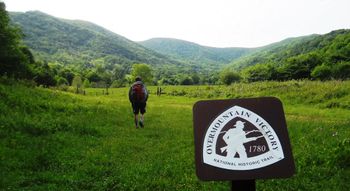
Overmountain Victory National Historic Trail
|
| Nearest City
|
Roan Mountain
|
| State
|
Tennessee
|
| Trail Marking
|
OVNHT icon
|
| Trail Use/Features
|

|
| Difficulty Rating
|
Medium
|
| Hiking Time
|
5-6"-6" is not declared as a valid unit of measurement for this property.
|
| Distance, round-trip
|
7.57.5 mi <br />12.07 km <br />
|
| Climb/Descent Elevation
|
16301,630 Feet <br />496.824 Meters <br /> / {{{Elevation Loss}}}"{{{Elevation Loss}}}" is not a number.
|
| High Point
|
46754,675 Feet <br />1,558.333 Yards <br />1,424.94 Meters <br />
|
| Nearest Medical
|
Elizabethton, TN
|
| Trip Reports
|
Click Here
|
|
|
Loading map... {"type":"ROADMAP","minzoom":false,"maxzoom":false,"types":["ROADMAP","SATELLITE","HYBRID","TERRAIN"],"mappingservice":"googlemaps3","width":"270px","height":"180px","centre":false,"title":"","label":"","icon":"","lines":[],"polygons":[],"circles":[],"rectangles":[],"copycoords":false,"static":false,"visitedicon":"","wmsoverlay":false,"zoom":8,"layers":[],"controls":["zoom"],"zoomstyle":"DEFAULT","typestyle":"DEFAULT","autoinfowindows":false,"resizable":false,"kmlrezoom":false,"poi":true,"cluster":false,"clustergridsize":60,"clustermaxzoom":20,"clusterzoomonclick":true,"clusteraveragecenter":true,"clusterminsize":2,"imageoverlays":[],"kml":[],"gkml":[],"searchmarkers":"","fullscreen":false,"scrollwheelzoom":false,"locations":[{"text":"","title":"","link":"","lat":36.1523830000000003792592906393110752105712890625,"lon":-82.055733000000003585228114388883113861083984375,"icon":""}]} |
|
| Show Large Map
|
|
Trail Overview
While the Overmountain Victory National Historic Trail stretches 330 miles, there are only a few segments that are not paved highway and open to the public. This page describes the 3.75 mile section located in the Hampton Creek Cove State Natural Area.
How to get there
From Johnson City, TN
- Head south on Roan Street for 3.5 miles passing under I-26.
- Take left/east onto TN359/Okolona Road and travel 1.4 miles.
- Take right/south onto TN361 over to US19E for nine miles. The road starts as Laurels Road, then Dry Creek Road and finally Gap Creek Road.
- Travel US19E for ten miles to town of Roan Mountain.
- Take right/south onto TN143.
- As soon as the highway divides take left/north onto Old Highway 143.
- Turn right/east onto Hampton Creek Road and proceed three miles.
- Parking area is on left/east side of road. Space for a dozen vehicles.
Route Description
From parking lot, head through gate through field with briars and cross old bridge to reach trail sign. Turn right to follow along fence row on left crossing an old wood bridge to intersect with farm road. The path initially proceeds through open meadows and along the Left Prong of Hampton Creek. CLOSE any gates as you pass through since livestock is grazed in the area. The route finally enter forest as a single path following the contour over a lower ridge. Once the path finds another old logging road it heads straight up Yellow Mountain with significant climb. At 3.75 miles, reach Appalachian Trail. Desirable is to head another 0.2 miles on the blue blaze at this intersection to Overmountain shelter, which is an old barn. Return by same route. Found only one sign for Birchfield Trail on the other side of the creek, but not a clear path.
The trail towards the highpoint is mostly up and up with two descending sections. Our steady pace was just under three hours up and two hours back down.
OVNHT continues into North Carolina for another 1.5 miles. From the A.T. is skirts the edge of a heavily grown field. A long shuttle could be arranged for an all day hike up and over the mountain. Alternatively, a shuttle at Carvers Gap would allow a just over ten mile hike on OVNHT and A.T.
Typical Conditions
The lower part of the route is on active dirt and rock farm roads. Also watch your step for deposits made by the grazed ponies and cattle. Two stream crossings have bridges, while others are forded on rocks while avoiding mud. Keep a close eye on the OVNHT icon blazes. The large metal ones are probably original from 2008 while the carbonite signs were installed in 2014 to give more guidance. Once through 4-5 farm gates, the trail veers right down to cross a stream. Long pants are recommended year around due to large amount of stinging nettle encountered once off the farm roads. A few blowdowns were observed with all able to step/climb over.
Fees, Permits, etc.
No permit or fee. The nature area closes at dusk. The trail officially says no mountain bikes or horses.
After the Hike
Misc. Information
Hampton Creek Cove is a 693-acre natural area. The official TN.gov Hampton Creek Cove webpage including map.
National Park Service website for OVMT
This section of the OVNHT was established in 2007-2008 per the March 2008 issue of the TEHCC newsletter. link
Maps
Loading map...
{"type":"TERRAIN","minzoom":false,"maxzoom":false,"types":["ROADMAP","SATELLITE","HYBRID","TERRAIN"],"mappingservice":"googlemaps3","width":"auto","height":"600px","centre":{"text":"","title":"","link":"","lat":36.1400000000000005684341886080801486968994140625,"lon":-82.055733000000003585228114388883113861083984375,"icon":""},"title":"","label":"","icon":"","lines":[],"polygons":[],"circles":[],"rectangles":[],"copycoords":false,"static":false,"visitedicon":"","wmsoverlay":false,"zoom":14,"layers":[],"controls":["pan","zoom","type","scale","streetview","rotate"],"zoomstyle":"DEFAULT","typestyle":"DEFAULT","autoinfowindows":false,"resizable":false,"kmlrezoom":false,"poi":true,"cluster":false,"clustergridsize":60,"clustermaxzoom":20,"clusterzoomonclick":true,"clusteraveragecenter":true,"clusterminsize":2,"imageoverlays":[],"kml":[],"gkml":["http://tehcc.org/clubwiki/kml/Overmountain_Victory_Trail.kml"],"searchmarkers":"","fullscreen":false,"scrollwheelzoom":false,"locations":[{"text":"\u003Cdiv class=\"mw-parser-output\"\u003E\u003Cp\u003EParking at Hampton Creek Cove State Natural Area\n\u003C/p\u003E\u003C/div\u003E","title":"Parking at Hampton Creek Cove State Natural Area\n","link":"","lat":36.1523830000000003792592906393110752105712890625,"lon":-82.055733000000003585228114388883113861083984375,"icon":"/clubwiki/images/MarkerA.png"},{"text":"\u003Cdiv class=\"mw-parser-output\"\u003E\u003Cp\u003EIntersection with Appalachian Trail\n\u003C/p\u003E\u003C/div\u003E","title":"Intersection with Appalachian Trail\n","link":"","lat":36.1258150000000028967406251467764377593994140625,"lon":-82.0513349999999945794115774333477020263671875,"icon":"/clubwiki/images/MarkerG.png"},{"text":"\u003Cdiv class=\"mw-parser-output\"\u003E\u003Cp\u003EOvermountain Shelter/Yellow Mtn Barn\n\u003C/p\u003E\u003C/div\u003E","title":"Overmountain Shelter/Yellow Mtn Barn\n","link":"","lat":36.123615000000000918589648790657520294189453125,"lon":-82.054214000000001760781742632389068603515625,"icon":"/clubwiki/images/MarkerF.png"}]}
Photos


