|
|
| (12 intermediate revisions by 4 users not shown) |
| Line 1: |
Line 1: |
| <!-- The following few lines create the "Infobox" table template. Please scroll down to edit the main content of the article. --> | | <!-- The following few lines create the "Infobox" table template. Please scroll down to edit the main content of the article. |
| {{Infobox Trail | | |
| | Image Name = OMVT1.jpg | | -->{{Infobox Trail |
| | | Image Name = HCCSNA_Blaze.jpg |
| | |Park=Hampton Creek Cove State Natural Area |
| | City = Roan Mountain | | | City = Roan Mountain |
| | State = Tennessee | | | State = Tennessee |
| | Marking = OVNHT icon | | | Marking = OVNHT icon |
| | Trail Use = {{Hike}} | | | Trail Use = {{Hike}} |
| | Difficulty Rating = Easy | | | Difficulty Rating = Medium |
| | Hike Time = 5 | | | Hike Time = 3 |
| | Distance = 7.5 | | | Distance = 4.4 |
| | Elevation Gain = ~1600 | | | Elevation Gain = 2148 |
| | High Point = ~4600 | | | Elevation Loss = -983 |
| | | High Point = 4686 |
| | Latitude = 36.152383 | | | Latitude = 36.152383 |
| | Longitude = -82.055733 | | | Longitude = -82.055733 |
| | Medical = Elizabethton, TN | | | Medical = Elizabethton, TN |
| }} | | }}<!-- |
| <!-- End Infobox template table--> | | |
| | End Infobox template table |
|
| |
|
| <!-- Start of Main Page --> | | -->{{Trail page needs |
| | | Hide needs = |
| | | KML = |
| | | Updated KML = |
| | | Detail route description = Yes |
| | | Photos = |
| | | Winter photos = |
| | | Remove prefix = |
| | | Update infobox = Yes |
| | | Infobox data update = Yes |
| | | Trail pins = |
| | | Other = |
| | | Comment = Need to figure out how to incorporate long trails with parks with shorter connections and side trips |
| | | Date reviewed = 10/25/2015 |
| | }}<!-- |
|
| |
|
| | Start of Main Page --> |
| == Trail Overview == | | == Trail Overview == |
| <!-- Enter a overview of the trail. What attracts you to this trail, points of interest, types of flowers, lakes, and peaks that you see along the way. --> | | <!-- Enter a overview of the trail. What attracts you to this trail, points of interest, types of flowers, lakes, and peaks that you see along the way. --> |
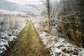
| While the Overmountain Victory National Historic Trail stretches 330 miles, there are only a few segments that are not paved highway and open to the public. This page describes the 3.75 mile section located in the Hampton Creek Cove State Natural Area. | | Located in the [[Hampton Creek Cove State Natural Area]]. |
| | |
| | While the Overmountain Victory National Historic Trail stretches 330 miles, there are only a few segments that are not paved highway and open to the public. |
|
| |
|
| == How to get there == | | == How to get there == |
| Line 31: |
Line 52: |
| #Travel US19E for ten miles to town of Roan Mountain. | | #Travel US19E for ten miles to town of Roan Mountain. |
| #Take right/south onto TN143. | | #Take right/south onto TN143. |
| #Cross bridge and then take left/east onto Stratton Street. | | #As soon as the highway divides take left/north onto Old Highway 143. |
| #Take right/south onto Old Highway 143/Sawdust Trail to Cloudland Elem School.
| | #Turn right/east onto Hampton Creek Road and proceed three miles. |
| #Turn left/east onto Hampton Creek Road and proceed three miles. | | #Parking area is on left/east side of road. Space for a dozen vehicles. |
| #Parking area is on left/east side of road. | |
|
| |
|
| == Route Description== | | == Route Description== |
| <!-- Detailed description of the route. Is there any side trails that are worth traveling? --> | | <!-- Detailed description of the route. Is there any side trails that are worth traveling? --> |
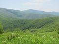
| From parking lot, initially proceed through open meadows and along the Left Prong of Hampton Creek. CLOSE any gates as you pass through since livestock is grazed in the area. Enter forest and continue up Yellow Mountain with significant climb. At 3.75 miles, reach Appalachian Trail. Desirable is to head another 0.2 miles to Overmountain shelter, which is an old barn. Return by same route or take Birchfield trail on the other side of the creek. | | From parking lot, head through gate through field with briars and cross old bridge to reach trail sign. Turn right to follow along fence row on left crossing an old wood bridge to intersect with farm road. The path initially proceeds through open meadows and along the Left Prong of Hampton Creek. CLOSE any gates as you pass through since livestock is grazed in the area. The route finally enter forest as a single path following the contour over a lower ridge. Once the path finds another old logging road it heads straight up Yellow Mountain with significant climb. At 3.75 miles, reach Appalachian Trail. Desirable is to head another 0.2 miles on the blue blaze at this intersection to Overmountain shelter, which is an old barn. Return by same route. Found only one sign for Birchfield Trail on the other side of the creek, but not a clear path. |
| | |
| | The trail towards the highpoint is mostly up and up with two descending sections. Our steady pace was just under three hours up and two hours back down. |
| | |
| | OVNHT continues into North Carolina for another 1.5 miles. From the A.T. is skirts the edge of a heavily grown field. A long shuttle could be arranged for an all day hike up and over the mountain. Alternatively, a shuttle at Carvers Gap would allow a just over ten mile hike on OVNHT and A.T. |
| | |
| | {| class="wikitable" border="1" |
| | |- |
| | !Miles |
| | !Notes |
| | |- |
| | |
| | |0.0 |
| | |Trailhead at Hampton Creek |
| | |- |
| | |
| | |0.1 |
| | |Bridge |
| | |- |
| | |
| | |0.2 |
| | |Bridge |
| | |- |
| | |
| | |0.3 |
| | |Farm Gate |
| | |- |
| | |
| | |0.4 |
| | |Farm Gate |
| | |- |
| | |
| | |0.55 |
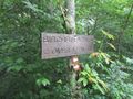
| | |Junction on [[Birchfield Trail]] |
| | |- |
| | |
| | |0.56 |
| | |Farm Gate |
| | |- |
| | |
| | |0.57 |
| | |Bridge |
| | |- |
| | |
| | |0.58 |
| | |Junction on [[Shell Hollow Trail]] |
| | |- |
| | |
| | |1.0 |
| | |Farm Gate |
| | |- |
|
| |
|
| OVNHT continues into North Carolina for another 1.5 miles. A long shuttle could be arranged for an all day hike up and over the mountain. Alternatively, a shuttle at Carvers Gap would allow a just over ten mile hike on OVNHT and A.T.
| | |1.3 |
| | |Farm Gate |
| | |- |
| | |
| | |1.5 |
| | |Farm Gate |
| | |- |
| | |
| | |1.55 |
| | |Junction on [[Birchfield Trail]] |
| | |- |
| | |
| | |1.75 |
| | |Trail leaves farm and enters woods |
| | |- |
| | |
| | |3.67 |
| | |Yellow Mountain Gap on AT |
| | |- |
| | |
| | |3.68 |
| | |Junction with Blue Blazed Trail to Barn |
| | |- |
| | |
| | |4.4 |
| | |Trailhead at Roaring Creek |
| | |} |
|
| |
|
| == Typical Conditions == | | == Typical Conditions == |
| <!-- Typical conditions throughout the year of what to expect on the trail. Rocky, muddy, sandy, flowers, lots of downed trees? --> | | <!-- Typical conditions throughout the year of what to expect on the trail. Rocky, muddy, sandy, flowers, lots of downed trees? --> |
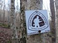
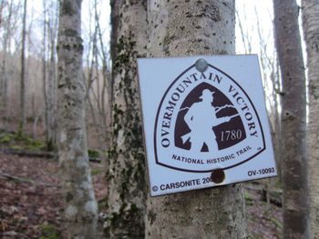
| | The lower part of the route is on active dirt and rock farm roads. Also watch your step for deposits made by the grazed ponies and cattle. Two stream crossings have bridges, while others are forded on rocks while avoiding mud. Keep a close eye on the OVNHT icon blazes. The large metal ones are probably original from 2008 while the carbonite signs were installed in 2014 to give more guidance. Once through 4-5 farm gates, the trail veers right down to cross a stream. Long pants are recommended year around due to large amount of stinging nettle encountered once off the farm roads. A few blowdowns were observed with all able to step/climb over. |
|
| |
|
| ==Fees, Permits, etc. == | | ==Fees, Permits, etc. == |
| Line 49: |
Line 146: |
| No permit or fee. The nature area closes at dusk. | | No permit or fee. The nature area closes at dusk. |
|
| |
|
| == After the Hike ==
| | NOTE Hunting is permitted. Use precaution when hiking during hunting season |
| <!-- Anywhere interesting to stop by since you're in the area!! -->
| |
|
| |
|
| == Misc. Information == | | == Misc. Information == |
| <!-- Enter any additional information that doesn't fit an any other fields. Does this trail require any permits for overnight? parking? --> | | <!-- Enter any additional information that doesn't fit an any other fields. Does this trail require any permits for overnight? parking? --> |
| Hampton Creek Cove is a 693-acre natural area. The official TN.gov Hampton Creek Cove [http://tn.gov/environment/natural-areas/natural-areas/hampton/ webpage] including [http://tn.gov/environment/natural-areas/natural-areas/hampton/na_hampton.pdf map].
| | [http://www.nps.gov/ovvi/index.htm National Park Service website for OVMT] |
|
| |
|
| [http://www.nps.gov/ovvi/index.htm National Park Service website for OVMT] | | This section of the OVNHT was established in 2007-2008 per the March 2008 issue of the TEHCC newsletter. [http://tehcc.org/pdf/newsletters/news200803.pdf link] |
|
| |
|
| == Maps == | | == Maps == |
| <googlemap lat="36.14" lon="-82.055733" type="terrain" zoom="14" height="600" scale="yes" icons="http://tehcc.org/clubwiki/kml/marker{label}.png"> | | Overmountain Victory National Historic Trail is red |
| http://tehcc.org/clubwiki/kml/Placeholder_trail.kml
| | |
| (A) 36.152383,-82.055733
| | <!-- You can place pictures, PDF's, links, or even create a Google map with your waypoints and place it here. --> |
| Parking at Hampton Creek Cove State Natural Area | | <display_map type="terrain" width="auto" height="600" gkml="https://tehcc.org/clubwiki/kml/HCCSNA_Birchfield_Trail.kml, |
| (G) 36.125815,-82.051335
| | https://tehcc.org/clubwiki/kml/HCCSNA_Overmountain_Shelter_Trail.kml, |
| Intersection with Appalachian Trail
| | https://tehcc.org/clubwiki/kml/HCCSNA_Overmountain_Victory_Trail.kml, |
| </googlemap> | | https://tehcc.org/clubwiki/kml/HCCSNA_Shell_Hollow_Trail.kml"> |
| | |
| | 36.1341375787, -82.0405528418~View into Hampton Cove~[[Image:HCCSNA_View_Into_Hampton_Cove.jpg|150px]]~MarkerB.png |
| | 36.1523127923, -82.0556224482~Hampton Cove Parking~ ~MarkerA.png |
| | 36.1170074500, -82.0489487139~Roaring Creek Parking~ ~MarkerA.png |
| | 36.1236150000, -82.0542140000~Overmountain Barn~[[Image:HCCSNA_Overmountain_Barn_From_AT.jpg|150px]]~MarkerF.png |
| | 36.1489500994, -82.0430267087~Shell Cemetery~ ~MarkerN.png |
| | 36.1404409560, -82.0468414829~Creek Crossing~[[Image:HCCSNA_Birchfield_Creek_Crossing.jpg|150px]]~MarkerJ.png |
| | 36.1410568100, -82.0461533500~Farm Gate~[[Image:HCCSNA_Farm_Gate_01.jpg|150px]]~MarkerG.png |
| | 36.1379704200, -82.0443995200~Farm Gate~[[Image:HCCSNA_Farm_Gate_02.jpg|150px]]~MarkerG.png |
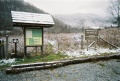
| | 36.1523057282, -82.0554279670~Trailhead Hampton Creek~[[Image:HCCSNA_Trailhead_Hampton_Creek.jpg|150px]]~MarkerT.png |
| | 36.1168907523, -82.0486987936~Trailhead Roaring Creek~[[Image:HCCSNA_Trailhead_Roaring_Creek.jpg|150px]]~MarkerT.png |
| | 36.1255151269, -82.0512409479~Trail Junction Shelter Trail~[[Image:HCCSNA_Junctions_Shelter_Trail.jpg|150px]]~MarkerT.png |
| | 36.1257587923, -82.0514537917~Yellow Mountain Gap Junction~[[Image:HCCSNA_Junctions_Yellow_Mountain_Gap.jpg|150px]]~MarkerT.png |
| | 36.1353754627, -82.0425103741~Junction Birchfield Trail North~[[Image:HCCSNA_Junctions_North.jpg|150px]]~MarkerT.png |
| | 36.1469884013, -82.0495906876~Junction Birchfield Trail South~[[Image:HCCSNA_Junctions_South.jpg|150px]]~MarkerT.png |
| | </display_map> |
|
| |
|
| == Photos == | | == Photos == |
| <gallery> | | <gallery> |
| | <!-- Place any pictures from this trail below. Add a picture by typing Image:imagename.extension --> |
| | Image:HCCSNA_View_Into_Hampton_Cove.jpg|View into Hampton Cove on OVNHT |
| | Image:HCCSNA_Overmountain_Barn_From_AT.jpg|Overmountain Barn viewed from the AT |
| | Image:HCCSNA_Farm_Gate_01.jpg|Farm Gate on OVNHT |
| | Image:HCCSNA_Farm_Gate_02.jpg|Farm Gate on OVNHT |
| | Image:HCCSNA_Trailhead_Hampton_Creek.jpg|Hampton Creek Trailhead |
| | Image:HCCSNA_Trailhead_Roaring_Creek.jpg|Roaring Creek Trailhead |
| | Image:HCCSNA_Junctions_Shelter_Trail.jpg|Shelter Trail Junction |
| | Image:HCCSNA_Junctions_Yellow_Mountain_Gap.jpg|Yellow Mountain Gap |
| | Image:HCCSNA_Junctions_North.jpg|Birchfield Trail North Junction |
| | Image:HCCSNA_Junctions_South.jpg|Birchfield Trail South Junction |
| | Image:HCCSNA_Blaze.jpg|Blaze |
| Image:OMVT1.jpg | | Image:OMVT1.jpg |
| Image:OMVT2.jpg | | Image:OMVT2.jpg |
| Line 74: |
Line 198: |
|
| |
|
| <!-- Categories --> | | <!-- Categories --> |
| [[Category:Overlook]] [[Category:Tennessee]] [[Category:Easy]] | | [[Category:Overlook]] [[Category:Tennessee]] [[Category:Medium]] |
|
|
|
|
|
| Trail Name
|
Overmountain Victory National Historic Trail
|
| Park
|
Hampton Creek Cove State Natural Area
|
| Nearest City
|
Roan Mountain
|
| State
|
Tennessee
|
| Trail Marking
|
OVNHT icon
|
| Trail Use/Features
|

|
| Difficulty Rating
|
Medium
|
| Hiking Time
|
33 Hours <br />0.188 Days <br />180 Min <br />
|
| Distance, round-trip
|
4.44.4 mi <br />7.081 km <br />
|
| Climb/Descent Elevation
|
21482,148 Feet <br />654.71 Meters <br /> / -983-983 Feet <br />-299.618 Meters <br />
|
| High Point
|
46864,686 Feet <br />1,562 Yards <br />1,428.293 Meters <br />
|
| Nearest Medical
|
Elizabethton, TN
|
| Trip Reports
|
Click Here
|
|
|
Loading map... {"type":"ROADMAP","minzoom":false,"maxzoom":false,"types":["ROADMAP","SATELLITE","HYBRID","TERRAIN"],"mappingservice":"googlemaps3","width":"270px","height":"180px","centre":false,"title":"","label":"","icon":"","lines":[],"polygons":[],"circles":[],"rectangles":[],"copycoords":false,"static":false,"visitedicon":"","wmsoverlay":false,"zoom":8,"layers":[],"controls":["zoom"],"zoomstyle":"DEFAULT","typestyle":"DEFAULT","autoinfowindows":false,"resizable":false,"kmlrezoom":false,"poi":true,"cluster":false,"clustergridsize":60,"clustermaxzoom":20,"clusterzoomonclick":true,"clusteraveragecenter":true,"clusterminsize":2,"imageoverlays":[],"kml":[],"gkml":[],"searchmarkers":"","fullscreen":false,"scrollwheelzoom":false,"locations":[{"text":"","title":"","link":"","lat":36.1523830000000003792592906393110752105712890625,"lon":-82.055733000000003585228114388883113861083984375,"icon":""}]} |
|
| Show Large Map
|
|
Trail Overview[edit]
Located in the Hampton Creek Cove State Natural Area.
While the Overmountain Victory National Historic Trail stretches 330 miles, there are only a few segments that are not paved highway and open to the public.
How to get there[edit]
From Johnson City, TN
- Head south on Roan Street for 3.5 miles passing under I-26.
- Take left/east onto TN359/Okolona Road and travel 1.4 miles.
- Take right/south onto TN361 over to US19E for nine miles. The road starts as Laurels Road, then Dry Creek Road and finally Gap Creek Road.
- Travel US19E for ten miles to town of Roan Mountain.
- Take right/south onto TN143.
- As soon as the highway divides take left/north onto Old Highway 143.
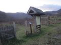
- Turn right/east onto Hampton Creek Road and proceed three miles.
- Parking area is on left/east side of road. Space for a dozen vehicles.
Route Description[edit]
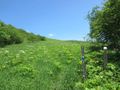
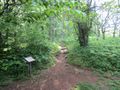
From parking lot, head through gate through field with briars and cross old bridge to reach trail sign. Turn right to follow along fence row on left crossing an old wood bridge to intersect with farm road. The path initially proceeds through open meadows and along the Left Prong of Hampton Creek. CLOSE any gates as you pass through since livestock is grazed in the area. The route finally enter forest as a single path following the contour over a lower ridge. Once the path finds another old logging road it heads straight up Yellow Mountain with significant climb. At 3.75 miles, reach Appalachian Trail. Desirable is to head another 0.2 miles on the blue blaze at this intersection to Overmountain shelter, which is an old barn. Return by same route. Found only one sign for Birchfield Trail on the other side of the creek, but not a clear path.
The trail towards the highpoint is mostly up and up with two descending sections. Our steady pace was just under three hours up and two hours back down.
OVNHT continues into North Carolina for another 1.5 miles. From the A.T. is skirts the edge of a heavily grown field. A long shuttle could be arranged for an all day hike up and over the mountain. Alternatively, a shuttle at Carvers Gap would allow a just over ten mile hike on OVNHT and A.T.
| Miles
|
Notes
|
| 0.0
|
Trailhead at Hampton Creek
|
| 0.1
|
Bridge
|
| 0.2
|
Bridge
|
| 0.3
|
Farm Gate
|
| 0.4
|
Farm Gate
|
| 0.55
|
Junction on Birchfield Trail
|
| 0.56
|
Farm Gate
|
| 0.57
|
Bridge
|
| 0.58
|
Junction on Shell Hollow Trail
|
| 1.0
|
Farm Gate
|
| 1.3
|
Farm Gate
|
| 1.5
|
Farm Gate
|
| 1.55
|
Junction on Birchfield Trail
|
| 1.75
|
Trail leaves farm and enters woods
|
| 3.67
|
Yellow Mountain Gap on AT
|
| 3.68
|
Junction with Blue Blazed Trail to Barn
|
| 4.4
|
Trailhead at Roaring Creek
|
Typical Conditions[edit]
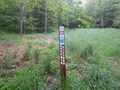
The lower part of the route is on active dirt and rock farm roads. Also watch your step for deposits made by the grazed ponies and cattle. Two stream crossings have bridges, while others are forded on rocks while avoiding mud. Keep a close eye on the OVNHT icon blazes. The large metal ones are probably original from 2008 while the carbonite signs were installed in 2014 to give more guidance. Once through 4-5 farm gates, the trail veers right down to cross a stream. Long pants are recommended year around due to large amount of stinging nettle encountered once off the farm roads. A few blowdowns were observed with all able to step/climb over.
Fees, Permits, etc.[edit]
No permit or fee. The nature area closes at dusk.
NOTE Hunting is permitted. Use precaution when hiking during hunting season
Misc. Information[edit]
National Park Service website for OVMT
This section of the OVNHT was established in 2007-2008 per the March 2008 issue of the TEHCC newsletter. link
Overmountain Victory National Historic Trail is red
Loading map...
{"type":"TERRAIN","minzoom":false,"maxzoom":false,"types":["ROADMAP","SATELLITE","HYBRID","TERRAIN"],"mappingservice":"googlemaps3","width":"auto","height":"600px","centre":false,"title":"","label":"","icon":"","lines":[],"polygons":[],"circles":[],"rectangles":[],"copycoords":false,"static":false,"visitedicon":"","wmsoverlay":false,"zoom":false,"layers":[],"controls":["pan","zoom","type","scale","streetview","rotate"],"zoomstyle":"DEFAULT","typestyle":"DEFAULT","autoinfowindows":false,"resizable":false,"kmlrezoom":false,"poi":true,"cluster":false,"clustergridsize":60,"clustermaxzoom":20,"clusterzoomonclick":true,"clusteraveragecenter":true,"clusterminsize":2,"imageoverlays":[],"kml":[],"gkml":["https://tehcc.org/clubwiki/kml/HCCSNA_Birchfield_Trail.kml","https://tehcc.org/clubwiki/kml/HCCSNA_Overmountain_Shelter_Trail.kml","https://tehcc.org/clubwiki/kml/HCCSNA_Overmountain_Victory_Trail.kml","https://tehcc.org/clubwiki/kml/HCCSNA_Shell_Hollow_Trail.kml"],"searchmarkers":"","fullscreen":false,"scrollwheelzoom":false,"locations":[{"text":"\u003Cb\u003E\u003Cdiv class=\"mw-parser-output\"\u003E\u003Cp\u003EView into Hampton Cove\n\u003C/p\u003E\u003C/div\u003E\u003C/b\u003E\u003Cdiv class=\"mw-parser-output\"\u003E\u003Cp\u003E\u003Ca href=\"/wiki/File:HCCSNA_View_Into_Hampton_Cove.jpg\" class=\"image\"\u003E\u003Cimg alt=\"HCCSNA View Into Hampton Cove.jpg\" src=\"/clubwiki/images/thumb/HCCSNA_View_Into_Hampton_Cove.jpg/150px-HCCSNA_View_Into_Hampton_Cove.jpg\" decoding=\"async\" width=\"150\" height=\"113\" srcset=\"/clubwiki/images/thumb/HCCSNA_View_Into_Hampton_Cove.jpg/225px-HCCSNA_View_Into_Hampton_Cove.jpg 1.5x, /clubwiki/images/thumb/HCCSNA_View_Into_Hampton_Cove.jpg/300px-HCCSNA_View_Into_Hampton_Cove.jpg 2x\" data-file-width=\"1200\" data-file-height=\"900\" /\u003E\u003C/a\u003E\n\u003C/p\u003E\u003C/div\u003E","title":"View into Hampton Cove\n","link":"","lat":36.13413757869999898275636951439082622528076171875,"lon":-82.0405528417999931889426079578697681427001953125,"icon":"/clubwiki/images/MarkerB.png"},{"text":"\u003Cdiv class=\"mw-parser-output\"\u003E\u003Cp\u003EHampton Cove Parking\n\u003C/p\u003E\u003C/div\u003E","title":"Hampton Cove Parking\n","link":"","lat":36.15231279230000183133597602136433124542236328125,"lon":-82.0556224481999976205770508386194705963134765625,"icon":"/clubwiki/images/MarkerA.png"},{"text":"\u003Cdiv class=\"mw-parser-output\"\u003E\u003Cp\u003ERoaring Creek Parking\n\u003C/p\u003E\u003C/div\u003E","title":"Roaring Creek Parking\n","link":"","lat":36.1170074500000026773705030791461467742919921875,"lon":-82.0489487139000033266711398027837276458740234375,"icon":"/clubwiki/images/MarkerA.png"},{"text":"\u003Cb\u003E\u003Cdiv class=\"mw-parser-output\"\u003E\u003Cp\u003EOvermountain Barn\n\u003C/p\u003E\u003C/div\u003E\u003C/b\u003E\u003Cdiv class=\"mw-parser-output\"\u003E\u003Cp\u003E\u003Ca href=\"/wiki/File:HCCSNA_Overmountain_Barn_From_AT.jpg\" class=\"image\"\u003E\u003Cimg alt=\"HCCSNA Overmountain Barn From AT.jpg\" src=\"/clubwiki/images/thumb/HCCSNA_Overmountain_Barn_From_AT.jpg/150px-HCCSNA_Overmountain_Barn_From_AT.jpg\" decoding=\"async\" width=\"150\" height=\"113\" srcset=\"/clubwiki/images/thumb/HCCSNA_Overmountain_Barn_From_AT.jpg/225px-HCCSNA_Overmountain_Barn_From_AT.jpg 1.5x, /clubwiki/images/thumb/HCCSNA_Overmountain_Barn_From_AT.jpg/300px-HCCSNA_Overmountain_Barn_From_AT.jpg 2x\" data-file-width=\"1200\" data-file-height=\"900\" /\u003E\u003C/a\u003E\n\u003C/p\u003E\u003C/div\u003E","title":"Overmountain Barn\n","link":"","lat":36.123615000000000918589648790657520294189453125,"lon":-82.054214000000001760781742632389068603515625,"icon":"/clubwiki/images/MarkerF.png"},{"text":"\u003Cdiv class=\"mw-parser-output\"\u003E\u003Cp\u003EShell Cemetery\n\u003C/p\u003E\u003C/div\u003E","title":"Shell Cemetery\n","link":"","lat":36.14895009939999681591871194541454315185546875,"lon":-82.0430267086999975845174049027264118194580078125,"icon":"/clubwiki/images/MarkerN.png"},{"text":"\u003Cb\u003E\u003Cdiv class=\"mw-parser-output\"\u003E\u003Cp\u003ECreek Crossing\n\u003C/p\u003E\u003C/div\u003E\u003C/b\u003E\u003Cdiv class=\"mw-parser-output\"\u003E\u003Cp\u003E\u003Ca href=\"/wiki/File:HCCSNA_Birchfield_Creek_Crossing.jpg\" class=\"image\"\u003E\u003Cimg alt=\"HCCSNA Birchfield Creek Crossing.jpg\" src=\"/clubwiki/images/thumb/HCCSNA_Birchfield_Creek_Crossing.jpg/150px-HCCSNA_Birchfield_Creek_Crossing.jpg\" decoding=\"async\" width=\"150\" height=\"113\" srcset=\"/clubwiki/images/thumb/HCCSNA_Birchfield_Creek_Crossing.jpg/225px-HCCSNA_Birchfield_Creek_Crossing.jpg 1.5x, /clubwiki/images/thumb/HCCSNA_Birchfield_Creek_Crossing.jpg/300px-HCCSNA_Birchfield_Creek_Crossing.jpg 2x\" data-file-width=\"1200\" data-file-height=\"900\" /\u003E\u003C/a\u003E\n\u003C/p\u003E\u003C/div\u003E","title":"Creek Crossing\n","link":"","lat":36.14044095599999906198718235827982425689697265625,"lon":-82.0468414829000067811648477800190448760986328125,"icon":"/clubwiki/images/MarkerJ.png"},{"text":"\u003Cb\u003E\u003Cdiv class=\"mw-parser-output\"\u003E\u003Cp\u003EFarm Gate\n\u003C/p\u003E\u003C/div\u003E\u003C/b\u003E\u003Cdiv class=\"mw-parser-output\"\u003E\u003Cp\u003E\u003Ca href=\"/wiki/File:HCCSNA_Farm_Gate_01.jpg\" class=\"image\"\u003E\u003Cimg alt=\"HCCSNA Farm Gate 01.jpg\" src=\"/clubwiki/images/thumb/HCCSNA_Farm_Gate_01.jpg/150px-HCCSNA_Farm_Gate_01.jpg\" decoding=\"async\" width=\"150\" height=\"113\" srcset=\"/clubwiki/images/thumb/HCCSNA_Farm_Gate_01.jpg/225px-HCCSNA_Farm_Gate_01.jpg 1.5x, /clubwiki/images/thumb/HCCSNA_Farm_Gate_01.jpg/300px-HCCSNA_Farm_Gate_01.jpg 2x\" data-file-width=\"1200\" data-file-height=\"900\" /\u003E\u003C/a\u003E\n\u003C/p\u003E\u003C/div\u003E","title":"Farm Gate\n","link":"","lat":36.14105681000000203084709937684237957000732421875,"lon":-82.04615334999999731735442765057086944580078125,"icon":"/clubwiki/images/MarkerG.png"},{"text":"\u003Cb\u003E\u003Cdiv class=\"mw-parser-output\"\u003E\u003Cp\u003EFarm Gate\n\u003C/p\u003E\u003C/div\u003E\u003C/b\u003E\u003Cdiv class=\"mw-parser-output\"\u003E\u003Cp\u003E\u003Ca href=\"/wiki/File:HCCSNA_Farm_Gate_02.jpg\" class=\"image\"\u003E\u003Cimg alt=\"HCCSNA Farm Gate 02.jpg\" src=\"/clubwiki/images/thumb/HCCSNA_Farm_Gate_02.jpg/150px-HCCSNA_Farm_Gate_02.jpg\" decoding=\"async\" width=\"150\" height=\"113\" srcset=\"/clubwiki/images/thumb/HCCSNA_Farm_Gate_02.jpg/225px-HCCSNA_Farm_Gate_02.jpg 1.5x, /clubwiki/images/thumb/HCCSNA_Farm_Gate_02.jpg/300px-HCCSNA_Farm_Gate_02.jpg 2x\" data-file-width=\"1200\" data-file-height=\"900\" /\u003E\u003C/a\u003E\n\u003C/p\u003E\u003C/div\u003E","title":"Farm Gate\n","link":"","lat":36.1379704200000020364313968457281589508056640625,"lon":-82.0443995199999989154093782417476177215576171875,"icon":"/clubwiki/images/MarkerG.png"},{"text":"\u003Cb\u003E\u003Cdiv class=\"mw-parser-output\"\u003E\u003Cp\u003ETrailhead Hampton Creek\n\u003C/p\u003E\u003C/div\u003E\u003C/b\u003E\u003Cdiv class=\"mw-parser-output\"\u003E\u003Cp\u003E\u003Ca href=\"/wiki/File:HCCSNA_Trailhead_Hampton_Creek.jpg\" class=\"image\"\u003E\u003Cimg alt=\"HCCSNA Trailhead Hampton Creek.jpg\" src=\"/clubwiki/images/thumb/HCCSNA_Trailhead_Hampton_Creek.jpg/150px-HCCSNA_Trailhead_Hampton_Creek.jpg\" decoding=\"async\" width=\"150\" height=\"113\" srcset=\"/clubwiki/images/thumb/HCCSNA_Trailhead_Hampton_Creek.jpg/225px-HCCSNA_Trailhead_Hampton_Creek.jpg 1.5x, /clubwiki/images/thumb/HCCSNA_Trailhead_Hampton_Creek.jpg/300px-HCCSNA_Trailhead_Hampton_Creek.jpg 2x\" data-file-width=\"1200\" data-file-height=\"900\" /\u003E\u003C/a\u003E\n\u003C/p\u003E\u003C/div\u003E","title":"Trailhead Hampton Creek\n","link":"","lat":36.15230572819999821376768522895872592926025390625,"lon":-82.0554279669999999669016688130795955657958984375,"icon":"/clubwiki/images/MarkerT.png"},{"text":"\u003Cb\u003E\u003Cdiv class=\"mw-parser-output\"\u003E\u003Cp\u003ETrailhead Roaring Creek\n\u003C/p\u003E\u003C/div\u003E\u003C/b\u003E\u003Cdiv class=\"mw-parser-output\"\u003E\u003Cp\u003E\u003Ca href=\"/wiki/File:HCCSNA_Trailhead_Roaring_Creek.jpg\" class=\"image\"\u003E\u003Cimg alt=\"HCCSNA Trailhead Roaring Creek.jpg\" src=\"/clubwiki/images/thumb/HCCSNA_Trailhead_Roaring_Creek.jpg/150px-HCCSNA_Trailhead_Roaring_Creek.jpg\" decoding=\"async\" width=\"150\" height=\"113\" srcset=\"/clubwiki/images/thumb/HCCSNA_Trailhead_Roaring_Creek.jpg/225px-HCCSNA_Trailhead_Roaring_Creek.jpg 1.5x, /clubwiki/images/thumb/HCCSNA_Trailhead_Roaring_Creek.jpg/300px-HCCSNA_Trailhead_Roaring_Creek.jpg 2x\" data-file-width=\"1200\" data-file-height=\"900\" /\u003E\u003C/a\u003E\n\u003C/p\u003E\u003C/div\u003E","title":"Trailhead Roaring Creek\n","link":"","lat":36.11689075230000156579990289174020290374755859375,"lon":-82.0486987935999962928690365515649318695068359375,"icon":"/clubwiki/images/MarkerT.png"},{"text":"\u003Cb\u003E\u003Cdiv class=\"mw-parser-output\"\u003E\u003Cp\u003ETrail Junction Shelter Trail\n\u003C/p\u003E\u003C/div\u003E\u003C/b\u003E\u003Cdiv class=\"mw-parser-output\"\u003E\u003Cp\u003E\u003Ca href=\"/wiki/File:HCCSNA_Junctions_Shelter_Trail.jpg\" class=\"image\"\u003E\u003Cimg alt=\"HCCSNA Junctions Shelter Trail.jpg\" src=\"/clubwiki/images/thumb/HCCSNA_Junctions_Shelter_Trail.jpg/150px-HCCSNA_Junctions_Shelter_Trail.jpg\" decoding=\"async\" width=\"150\" height=\"113\" srcset=\"/clubwiki/images/thumb/HCCSNA_Junctions_Shelter_Trail.jpg/225px-HCCSNA_Junctions_Shelter_Trail.jpg 1.5x, /clubwiki/images/thumb/HCCSNA_Junctions_Shelter_Trail.jpg/300px-HCCSNA_Junctions_Shelter_Trail.jpg 2x\" data-file-width=\"1200\" data-file-height=\"900\" /\u003E\u003C/a\u003E\n\u003C/p\u003E\u003C/div\u003E","title":"Trail Junction Shelter Trail\n","link":"","lat":36.1255151268999981084562023170292377471923828125,"lon":-82.05124094789999844579142518341541290283203125,"icon":"/clubwiki/images/MarkerT.png"},{"text":"\u003Cb\u003E\u003Cdiv class=\"mw-parser-output\"\u003E\u003Cp\u003EYellow Mountain Gap Junction\n\u003C/p\u003E\u003C/div\u003E\u003C/b\u003E\u003Cdiv class=\"mw-parser-output\"\u003E\u003Cp\u003E\u003Ca href=\"/wiki/File:HCCSNA_Junctions_Yellow_Mountain_Gap.jpg\" class=\"image\"\u003E\u003Cimg alt=\"HCCSNA Junctions Yellow Mountain Gap.jpg\" src=\"/clubwiki/images/thumb/HCCSNA_Junctions_Yellow_Mountain_Gap.jpg/150px-HCCSNA_Junctions_Yellow_Mountain_Gap.jpg\" decoding=\"async\" width=\"150\" height=\"113\" srcset=\"/clubwiki/images/thumb/HCCSNA_Junctions_Yellow_Mountain_Gap.jpg/225px-HCCSNA_Junctions_Yellow_Mountain_Gap.jpg 1.5x, /clubwiki/images/thumb/HCCSNA_Junctions_Yellow_Mountain_Gap.jpg/300px-HCCSNA_Junctions_Yellow_Mountain_Gap.jpg 2x\" data-file-width=\"1200\" data-file-height=\"900\" /\u003E\u003C/a\u003E\n\u003C/p\u003E\u003C/div\u003E","title":"Yellow Mountain Gap Junction\n","link":"","lat":36.12575879229999742392465122975409030914306640625,"lon":-82.05145379169999841906246729195117950439453125,"icon":"/clubwiki/images/MarkerT.png"},{"text":"\u003Cb\u003E\u003Cdiv class=\"mw-parser-output\"\u003E\u003Cp\u003EJunction Birchfield Trail North\n\u003C/p\u003E\u003C/div\u003E\u003C/b\u003E\u003Cdiv class=\"mw-parser-output\"\u003E\u003Cp\u003E\u003Ca href=\"/wiki/File:HCCSNA_Junctions_North.jpg\" class=\"image\"\u003E\u003Cimg alt=\"HCCSNA Junctions North.jpg\" src=\"/clubwiki/images/thumb/HCCSNA_Junctions_North.jpg/150px-HCCSNA_Junctions_North.jpg\" decoding=\"async\" width=\"150\" height=\"113\" srcset=\"/clubwiki/images/thumb/HCCSNA_Junctions_North.jpg/225px-HCCSNA_Junctions_North.jpg 1.5x, /clubwiki/images/thumb/HCCSNA_Junctions_North.jpg/300px-HCCSNA_Junctions_North.jpg 2x\" data-file-width=\"1200\" data-file-height=\"900\" /\u003E\u003C/a\u003E\n\u003C/p\u003E\u003C/div\u003E","title":"Junction Birchfield Trail North\n","link":"","lat":36.1353754626999972288103890605270862579345703125,"lon":-82.04251037410000435556867159903049468994140625,"icon":"/clubwiki/images/MarkerT.png"},{"text":"\u003Cb\u003E\u003Cdiv class=\"mw-parser-output\"\u003E\u003Cp\u003EJunction Birchfield Trail South\n\u003C/p\u003E\u003C/div\u003E\u003C/b\u003E\u003Cdiv class=\"mw-parser-output\"\u003E\u003Cp\u003E\u003Ca href=\"/wiki/File:HCCSNA_Junctions_South.jpg\" class=\"image\"\u003E\u003Cimg alt=\"HCCSNA Junctions South.jpg\" src=\"/clubwiki/images/thumb/HCCSNA_Junctions_South.jpg/150px-HCCSNA_Junctions_South.jpg\" decoding=\"async\" width=\"150\" height=\"113\" srcset=\"/clubwiki/images/thumb/HCCSNA_Junctions_South.jpg/225px-HCCSNA_Junctions_South.jpg 1.5x, /clubwiki/images/thumb/HCCSNA_Junctions_South.jpg/300px-HCCSNA_Junctions_South.jpg 2x\" data-file-width=\"1200\" data-file-height=\"900\" /\u003E\u003C/a\u003E\n\u003C/p\u003E\u003C/div\u003E","title":"Junction Birchfield Trail South\n","link":"","lat":36.14698840129999979353669914416968822479248046875,"lon":-82.0495906876000020702122128568589687347412109375,"icon":"/clubwiki/images/MarkerT.png"}]}
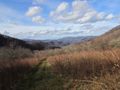
View into Hampton Cove on OVNHT
Overmountain Barn viewed from the AT
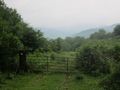
Birchfield Trail North Junction
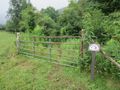
Birchfield Trail South Junction