Warning: This area will be very busy during soccer and boating seasons.
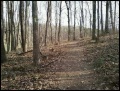
Trailhead appears to be a different location than what indicated on park map. Follow the light green blazed trail. There are many spur trails created from the neighborhood and disc golf course. The following hike detail describes hiking the loop in a clockwise direction.
Heavily used park trail is generally wide and kept open of the blowdowns (mostly pine dying due to the bore beetle).
No fee required.
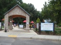
For families with pre-school to early elementary children, the Darrell's Dream boundless playground offers many ways to burn off excess energy.
Loading map...
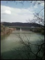
{"type":"TERRAIN","minzoom":false,"maxzoom":false,"types":["ROADMAP","SATELLITE","HYBRID","TERRAIN"],"mappingservice":"googlemaps3","width":"auto","height":"550px","centre":{"text":"","title":"","link":"","lat":36.4902799999999984947862685658037662506103515625,"lon":-82.4779999999999944293449516408145427703857421875,"icon":""},"title":"","label":"","icon":"","lines":[],"polygons":[],"circles":[],"rectangles":[],"copycoords":false,"static":false,"visitedicon":"","wmsoverlay":false,"zoom":15,"layers":[],"controls":["pan","zoom","type","scale","streetview","rotate"],"zoomstyle":"DEFAULT","typestyle":"DEFAULT","autoinfowindows":false,"resizable":false,"kmlrezoom":false,"poi":true,"cluster":false,"clustergridsize":60,"clustermaxzoom":20,"clusterzoomonclick":true,"clusteraveragecenter":true,"clusterminsize":2,"imageoverlays":[],"kml":[],"gkml":["http://tehcc.org/clubwiki/kml/WPSP_Overlook_Trail.kml"],"searchmarkers":"","fullscreen":false,"scrollwheelzoom":false,"locations":[{"text":"\u003Cdiv class=\"mw-parser-output\"\u003E\u003Cp\u003EOverlook trailhead at soccer field parking\n\u003C/p\u003E\u003C/div\u003E","title":"Overlook trailhead at soccer field parking\n","link":"","lat":36.4902799999999984947862685658037662506103515625,"lon":-82.477180000000004156390787102282047271728515625,"icon":"/clubwiki/images/MarkerA.png"},{"text":"\u003Cb\u003E\u003Cdiv class=\"mw-parser-output\"\u003E\u003Cp\u003EDouble Blaze-RR Tie steps\n\u003C/p\u003E\u003C/div\u003E\u003C/b\u003E\u003Cdiv class=\"mw-parser-output\"\u003E\u003Cp\u003E\u003Ca href=\"/wiki/File:WPSP_Overlook_Trail_sign.jpg\" class=\"image\" title=\"Trailhead sign\"\u003E\u003Cimg alt=\"Trailhead sign\" src=\"/clubwiki/images/thumb/WPSP_Overlook_Trail_sign.jpg/150px-WPSP_Overlook_Trail_sign.jpg\" decoding=\"async\" width=\"150\" height=\"199\" srcset=\"/clubwiki/images/thumb/WPSP_Overlook_Trail_sign.jpg/225px-WPSP_Overlook_Trail_sign.jpg 1.5x, /clubwiki/images/WPSP_Overlook_Trail_sign.jpg 2x\" data-file-width=\"265\" data-file-height=\"351\" /\u003E\u003C/a\u003E\n\u003C/p\u003E\u003C/div\u003E","title":"Double Blaze-RR Tie steps\n","link":"","lat":36.48669799999999696638042223639786243438720703125,"lon":-82.48016300000000455838744528591632843017578125,"icon":"/clubwiki/images/MarkerG.png"},{"text":"\u003Cdiv class=\"mw-parser-output\"\u003E\u003Cp\u003EOverlook #1\n\u003C/p\u003E\u003C/div\u003E","title":"Overlook #1\n","link":"","lat":36.4879499999999978854248183779418468475341796875,"lon":-82.4794399999999967576513881795108318328857421875,"icon":"/clubwiki/images/MarkerE.png"},{"text":"\u003Cb\u003E\u003Cdiv class=\"mw-parser-output\"\u003E\u003Cp\u003EOverlook #2\n\u003C/p\u003E\u003C/div\u003E\u003C/b\u003E\u003Cdiv class=\"mw-parser-output\"\u003E\u003Cp\u003E\u003Ca href=\"/wiki/File:WPSP_Overlook_Trail_-_Viewing_I-81_Bridge.jpg\" class=\"image\" title=\"I-81 Bridge over Ft. Patrick Henry Lake\"\u003E\u003Cimg alt=\"I-81 Bridge over Ft. Patrick Henry Lake\" src=\"/clubwiki/images/thumb/WPSP_Overlook_Trail_-_Viewing_I-81_Bridge.jpg/150px-WPSP_Overlook_Trail_-_Viewing_I-81_Bridge.jpg\" decoding=\"async\" width=\"150\" height=\"199\" srcset=\"/clubwiki/images/thumb/WPSP_Overlook_Trail_-_Viewing_I-81_Bridge.jpg/225px-WPSP_Overlook_Trail_-_Viewing_I-81_Bridge.jpg 1.5x, /clubwiki/images/WPSP_Overlook_Trail_-_Viewing_I-81_Bridge.jpg 2x\" data-file-width=\"265\" data-file-height=\"351\" /\u003E\u003C/a\u003E\n\u003C/p\u003E\u003C/div\u003E","title":"Overlook #2\n","link":"","lat":36.48718999999999823558027856051921844482421875,"lon":-82.479950000000002319211489520967006683349609375,"icon":"/clubwiki/images/MarkerE.png"},{"text":"\u003Cb\u003E\u003Cdiv class=\"mw-parser-output\"\u003E\u003Cp\u003EDarrell's Dream boundless playground\n\u003C/p\u003E\u003C/div\u003E\u003C/b\u003E\u003Cdiv class=\"mw-parser-output\"\u003E\u003Cp\u003E\u003Ca href=\"/wiki/File:WPSP_Darrel%27s_Dream_playground.jpg\" class=\"image\"\u003E\u003Cimg alt=\"WPSP Darrel\u0026#39;s Dream playground.jpg\" src=\"/clubwiki/images/thumb/WPSP_Darrel%27s_Dream_playground.jpg/150px-WPSP_Darrel%27s_Dream_playground.jpg\" decoding=\"async\" width=\"150\" height=\"113\" srcset=\"/clubwiki/images/thumb/WPSP_Darrel%27s_Dream_playground.jpg/225px-WPSP_Darrel%27s_Dream_playground.jpg 1.5x, /clubwiki/images/thumb/WPSP_Darrel%27s_Dream_playground.jpg/300px-WPSP_Darrel%27s_Dream_playground.jpg 2x\" data-file-width=\"600\" data-file-height=\"450\" /\u003E\u003C/a\u003E\n\u003C/p\u003E\u003C/div\u003E","title":"Darrell's Dream boundless playground\n","link":"","lat":36.49072000000000315367287839762866497039794921875,"lon":-82.4822300000000012687451089732348918914794921875,"icon":"/clubwiki/images/MarkerO.png"}]}